Ohio’s Miami Valley Faces Sunday Severe Storm Risk With Dayton, Cincinnati, Columbus, and Surrounding Cities in Line for Hail and Damaging Winds
OHIO — A developing storm system is expected to bring scattered severe thunderstorms across the Miami Valley Sunday evening into Sunday night, placing cities like Dayton, Cincinnati, Columbus, and surrounding communities under a growing weather threat.
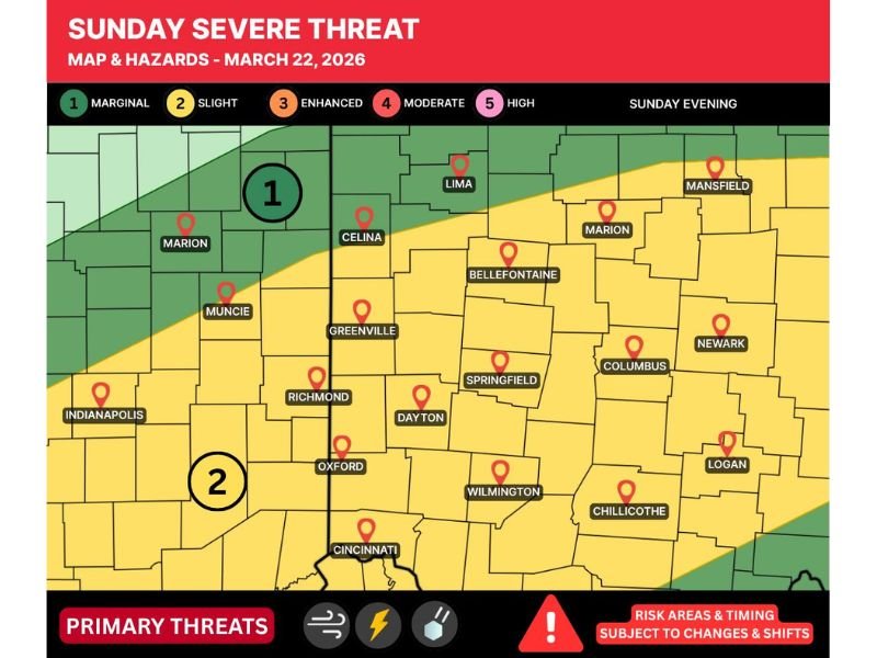
Slight Risk Covers Much of Western and Central Ohio
The latest outlook places a Level 2 (Slight Risk) across a wide portion of the Miami Valley, including Dayton, Springfield, Wilmington, Cincinnati, Columbus, Newark, and Chillicothe.
Nearby areas such as Richmond and Muncie in Indiana are also included in the risk zone, highlighting a broader regional setup that extends beyond state lines. Northern areas closer to Lima and Marion sit near a lower risk boundary but could still see storm activity.
Storms Expected to Develop by Evening
Current projections suggest storms will begin to develop later in the day Sunday, with the most active period expected during the evening into nighttime hours.
While exact timing remains somewhat uncertain, the window for severe weather appears to focus on the late afternoon through late evening, particularly as storms organize and move across western into central Ohio.
Main Threats Include Hail and Damaging Winds
The primary hazards with these storms will be large hail and strong, damaging wind gusts. Early storm development could feature isolated supercells capable of producing significant hail, especially in western portions of the risk area.
As storms evolve, there is potential for them to merge into a more organized line, increasing the risk for widespread wind damage as they track eastward.
It is important to note that while supercells are possible, not all storms will produce tornadoes, and the overall tornado threat remains uncertain at this time.
Coverage and Intensity Still Uncertain
Forecast confidence is still evolving, with some uncertainty regarding how widespread storms will become and how intense they will be across the region.
Some areas may see multiple rounds of storms, while others could experience little to no severe weather. This variability is tied to ongoing model differences and the exact placement of key atmospheric features.
What Residents Should Expect
Residents across the Miami Valley should stay alert for rapid weather changes Sunday evening, especially if storms begin to intensify quickly.
Cities including Dayton, Cincinnati, Columbus, Springfield, and Wilmington could all see periods of strong storms capable of producing hazardous conditions in a short amount of time.
Final Outlook
While this is not a high-end severe weather outbreak, the setup is strong enough to support localized severe storms across a densely populated portion of Ohio and nearby Indiana.
With hail and damaging winds as the primary threats, even isolated storms could cause disruptions Sunday evening into the overnight hours.
Stay with CabarrusWeekly.com for continuing updates as this forecast becomes clearer, and share your local conditions if storms impact your area.