Pennsylvania, Ohio, West Virginia and Maryland Face Sunday Supercell Threat With Egg-Sized Hail Up to 2 Inches Possible
OHIO VALLEY AND CENTRAL APPALACHIANS — A volatile storm setup is expected Sunday across Pennsylvania, Ohio, West Virginia, and Maryland, where rotating thunderstorms could produce large to potentially destructive hail.
Rotating Supercells Could Produce Significant Hail
Forecast guidance shows a corridor of organized, rotating thunderstorms (supercells) developing along and just north of the Ohio River into southwestern and south-central Pennsylvania.
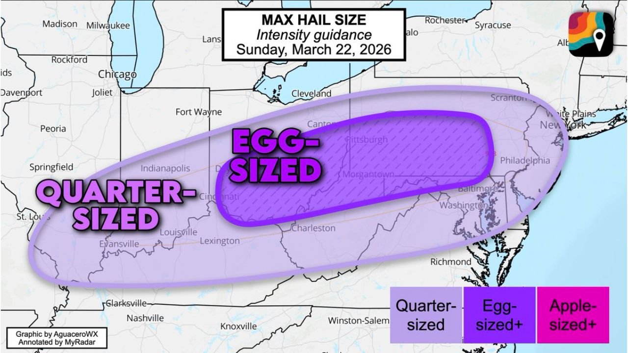
These storms are expected to be highly efficient hail producers, with the potential for hail up to 2 inches in diameter (egg-sized). This level of hail can cause vehicle damage, shattered windows, and significant impacts to outdoor property.
The most favorable zone for the largest hail stretches from eastern Ohio through western and central Pennsylvania into parts of Maryland.
Hail Risk Extends Across a Broad Corridor
A wider area from Indiana and Ohio through West Virginia and into Pennsylvania could still see quarter-sized hail or larger, especially during the early stages of storm development.
As storms organize, the hail threat may fluctuate, but the presence of rotating updrafts increases the likelihood of larger hailstones forming and surviving to the ground.
This corridor represents one of the more focused severe weather risks for Sunday.
Limited Tornado Threat but Not Zero
Despite the presence of rotating storms, the tornado risk remains low but not entirely zero.
The main limiting factor is dry air near the surface and limited low-level moisture, which prevents storms from fully connecting rotation down to the ground.
However, forecasters caution that if moisture levels increase more than expected, a brief or isolated tornado cannot be ruled out, particularly in western portions of the risk area.
Why This Setup Favors Large Hail
This pattern is a classic example of an “elevated severe weather setup”, where storms form above a cooler, drier surface layer.
In these environments, strong updrafts can rotate and remain stable long enough to grow hailstones significantly, without necessarily producing tornadoes.
As a result, the primary hazard shifts toward large hail rather than widespread wind or tornado damage, especially during the initial phases of storm development.
Timing and Areas of Greatest Concern
The most active period is expected Sunday afternoon into Sunday evening, when instability and lift are strongest.
Key areas to monitor include Pittsburgh, Morgantown, Harrisburg, and surrounding regions, where storms could rapidly intensify and produce severe hail.
Conditions may evolve quickly, with storms forming and strengthening over a relatively short window of time.
What This Means for Nearby Regions
Areas just outside the core zone may still experience thunderstorms with smaller hail and gusty winds, but the most significant impacts remain concentrated along the Ohio Valley into Pennsylvania.
Residents in the affected areas should be prepared for rapidly changing weather conditions, especially during peak storm hours.
Stay with CabarrusWeekly.com for continued updates on this developing severe weather threat. If you encounter hail or storms in your area, share your reports with the CabarrusWeekly.com community.