Ohio, Indiana, Pennsylvania and I-70 Corridor Face Conditional Sunday Severe Storm Threat With Large Hail as Primary Risk
OHIO VALLEY — A conditional severe weather setup is expected to develop Sunday near and south of the I-70 corridor, bringing the potential for thunderstorms capable of producing large hail across parts of Ohio, Indiana, and Pennsylvania.
Cold Front Drops Southward Sunday Evening
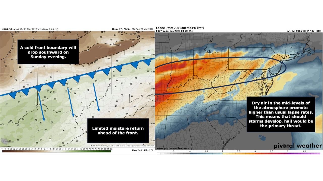
A cold front boundary is forecast to sag southward Sunday evening, acting as the primary trigger for thunderstorm development.
This boundary will move into a region with modest instability, allowing storms to form along and just ahead of the front, particularly across central Indiana, Ohio, and into Pennsylvania.
However, the overall setup is not strongly dynamic, keeping the threat more localized rather than widespread.
Limited Moisture Keeps Threat Conditional
One of the key limiting factors in this setup is low moisture return ahead of the front, which reduces the overall intensity and coverage of storms.
Dew point values remain relatively modest, meaning storms may struggle to fully organize or sustain severe intensity across large areas.
As a result, this is considered a conditional severe threat, dependent on whether enough instability develops for storms to strengthen.
Steep Lapse Rates Favor Large Hail Development
Despite limited moisture, atmospheric profiles show steep lapse rates, meaning temperatures decrease rapidly with height.
This is a critical ingredient for hail production, as it supports strong updrafts capable of suspending and growing hailstones.
If storms are able to develop, the primary hazard will be large hail, potentially reaching severe criteria in isolated locations.
Tornado and Wind Threats Remain Low
Due to the lack of strong low-level moisture and limited wind shear near the surface, the tornado risk is minimal.
Likewise, while some storms could produce gusty winds, widespread damaging wind events are not the primary concern in this setup.
The focus remains clearly on hail as the dominant severe weather threat.
Areas Along and South of I-70 Most Favored
The highest potential for storm development appears to be near and just south of the I-70 corridor, including cities such as Indianapolis, Columbus, and areas west of Pittsburgh.
Storms that form in this zone will have the best chance to tap into available instability and produce hail.
Farther north, conditions become less favorable, reducing the likelihood of severe weather.
What This Means Going Into Sunday
Residents across the Ohio Valley should monitor conditions Sunday afternoon and evening, especially if storms begin to develop along the advancing front.
While not a guaranteed severe weather event, any storms that do form could quickly become hail producers, leading to localized impacts.
Stay with CabarrusWeekly.com for continued updates as this conditional severe weather setup evolves. If storms develop in your area, share your conditions with the CabarrusWeekly.com community.