Utah Alta Ski Area Could See 1 to 2 Feet of Snow Next Week as Cooler Pattern Replaces Recent Heat
UTAH — After a stretch of unusual warmth, a pattern shift is expected to bring significant snowfall back to the mountains, with projections showing 1 to 2 feet of snow possible near Alta Ski Area next week.
Snowfall Potential Increasing Into Early April
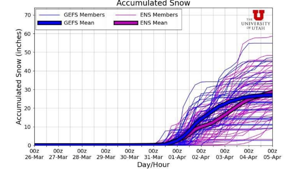
Forecast guidance shows snowfall beginning to build late March into early April, with the most notable accumulation expected during the first few days of April.
Current projections suggest total snowfall between 12 and 24 inches, especially across higher elevations like Alta and the Wasatch Range.
This marks a clear shift from the recent warm and dry conditions that have dominated the region.
Strong Model Signal for Accumulating Snow
Multiple forecast models indicate a consistent and strengthening signal for snow accumulation, with totals steadily increasing over several days.
While exact totals may still vary, the trend supports a multi-day snow event rather than a single storm, which could allow snow to build gradually.
This type of setup often results in periods of moderate to heavy snowfall across mountain areas.
Much Needed Change After Recent Warm Conditions
Recent weather has been unusually warm, contributing to snowpack loss and early melting across parts of Utah’s mountains.
This incoming system represents a return to more typical late-season conditions, offering at least some improvement to current snowpack levels.
However, despite this snowfall, it may not be enough to fully recover losses caused by earlier warmth.
Timing Still Has Some Uncertainty
Although confidence is increasing, there is still lead time before the event, meaning snowfall amounts and timing could shift slightly.
Forecast updates over the coming days will provide a clearer picture of storm intensity and duration.
Residents and travelers should continue to monitor updates as the system approaches.
Spring Pattern Turning More Active
This setup signals a broader shift toward a more active spring pattern, where warmer periods are interrupted by incoming storm systems.
For Utah’s mountains, this means renewed chances for snowfall even as the season transitions toward spring.
Residents and visitors heading to Alta and surrounding mountain areas are encouraged to stay updated on conditions. Share what you’re seeing and follow the latest coverage on CabarrusWeekly.com.