Socal Cool-down Confirmed: Cooler Temperatures and Light Rain Move in Tuesday through Thursday
LOS ANGELES, CALIFORNIA — A weak low pressure system is moving into Southern California, and with it comes something residents have been waiting for: cooler air and a chance of rain. The cool-down arrives Tuesday, March 31 and sticks around through Thursday, April 2, 2026 — giving the Southland a genuine mid-week reset before the weekend.
The forecast was issued by the National Weather Service Los Angeles/Oxnard office on March 27, 2026.
What to expect and when
The timing of this system matters. Here is a day-by-day breakdown of what Southern California can expect:
Tuesday, March 31 — Clouds increase throughout the day. Temperatures begin to drop noticeably by afternoon. Light rain develops by evening, primarily along the coast and foothills. Highs in the upper 60s to low 70s.
Wednesday, April 1 — The wettest day of the three. Light to moderate rainfall possible across the region through the morning and early afternoon hours. Mountain areas will see the highest totals. Highs remain in the mid to upper 60s.
Thursday, April 2 — Rain tapers off through the morning. Skies slowly clear by afternoon. Temperatures begin recovering slightly. A few lingering showers possible in the mountains through the evening.
Forecast confidence level
High confidence on the cool-down — temperatures dropping toward seasonal norms is locked in regardless of how the system evolves.
Medium confidence on rainfall totals — the exact track and strength of the low pressure system will determine how much rain actually falls, especially for urban areas like Los Angeles. Mountain and coastal communities are more likely to see the higher end of rainfall estimates.
Temperatures drop back to where they should be
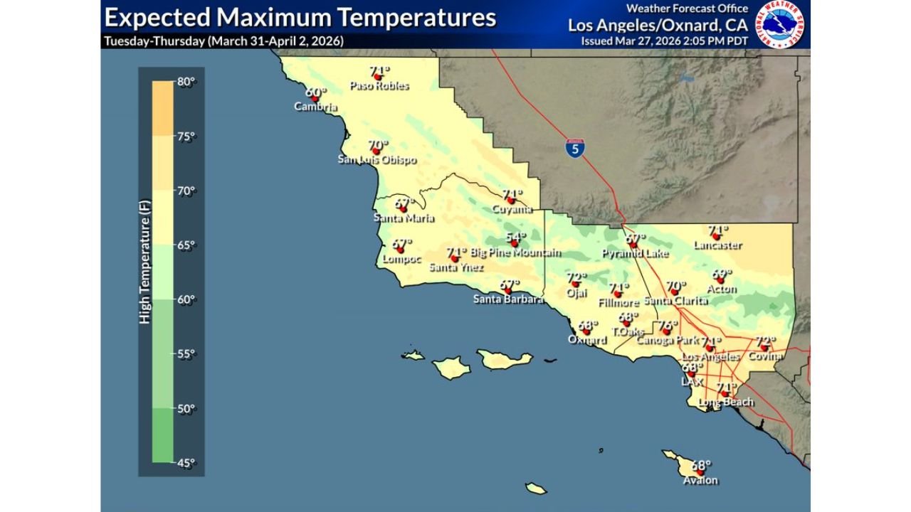
No extremes here — just a return to seasonal norms. Highs across most of SoCal will land in the upper 60s to low 70s°F, right where late March temperatures are supposed to be.
Here’s the city-by-city breakdown:
| City | Expected High |
|---|---|
| Los Angeles | 71°F |
| Long Beach | 71°F |
| LAX | 68°F |
| Canoga Park | 72°F |
| Santa Clarita | 70°F |
| Oxnard | 68°F |
| Santa Barbara | 67°F |
| Ojai | 70°F |
| Fillmore | 71°F |
| Lancaster | 71°F |
| Acton | 69°F |
| San Luis Obispo | 70°F |
| Paso Robles | 71°F |
| Cambria | 60°F |
Coastal communities will feel the coolest conditions of the bunch, while inland valleys stay comfortably in the low 70s.
Light rain is coming — but don’t cancel your plans
This system is not a major storm. Rainfall totals are expected to stay well under 0.25 inches across the entire region — for most of urban LA, it’ll barely wet the sidewalk.
The heaviest rain will fall across mountain and coastal communities:
| City | Expected Rainfall |
|---|---|
| Cambria | 0.15″ |
| Big Pine Mountain | 0.13″ |
| Ojai | 0.09″ |
| San Luis Obispo | 0.08″ |
| Santa Barbara | 0.07″ |
| Santa Ynez | 0.07″ |
| Lompoc | 0.06″ |
| Pyramid Lake | 0.05″ |
| Santa Maria | 0.04″ |
| Paso Robles | 0.04″ |
| Oxnard | 0.03″ |
| Fillmore | 0.03″ |
| Canoga Park | 0.02″ |
| Los Angeles / LAX / Long Beach | Trace |
What to wear and how to prepare
Light jacket or hoodie — mornings and evenings will feel noticeably cooler, especially near the coast.
A compact umbrella — rain will be light, but having one handy Tuesday through Thursday is a smart call.
Comfortable layers — afternoons will be mild and pleasant, so a light layer you can peel off works best.
Give yourself extra drive time — even a light drizzle can make SoCal roads slippery, especially during the first minutes of rain after a dry spell.
Heading to the mountains? Check road conditions before you go — higher terrain like Big Pine Mountain will see the most rainfall from this system.
The bottom line
This is a welcome cool-down, not a cause for concern. Southern California will see mild, overcast skies mid-week with light rain and no severe weather threats. Enjoy the fresh air — and the break from the heat.
For the latest updates as the system approaches, monitor weather.gov/lox closely through the weekend.
Bookmark cabarrusweekly.com and turn on notifications so you never miss a weather update, storm alert, or forecast change across the United States — delivered daily, before the weather hits.