Illinois, Indiana, Michigan, Ohio Face Two-Round Severe Storm Threat With Overnight Hail Then Tuesday Night Wind and Tornado Risk
OHIO VALLEY — A multi-round severe weather pattern is unfolding across the Midwest and Great Lakes, with two distinct storm systems expected from Monday evening through early Wednesday, bringing waves of hail, damaging winds, and a growing tornado threat.
First Round Arrives Monday Night Into Tuesday Morning
The initial round of storms is expected to develop Monday evening (March 30) and continue overnight into early Tuesday (March 31).
This phase targets areas including eastern Iowa, northern Illinois, southern Wisconsin, and western Michigan, with storms gradually pushing east.
The primary hazards in this round include wind gusts over 40 mph and hail, particularly across cities like Dubuque, Rockford, Milwaukee, and Grand Rapids.
Because these storms are expected to be somewhat elevated, the severe threat will focus more on hail and gusty winds rather than tornado development during the overnight hours.
Elevated Storms Bring Overnight Hail Risk
The overnight setup favors elevated supercells, which are capable of producing pockets of large hail even after sunset.
Some areas could see hail approaching 1 inch in diameter, especially across northern Illinois into western Michigan.
This makes the late-night period particularly important, as storms may remain active while many people are asleep, increasing the risk of unnoticed impacts.
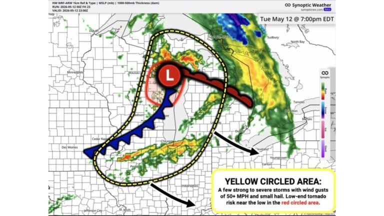
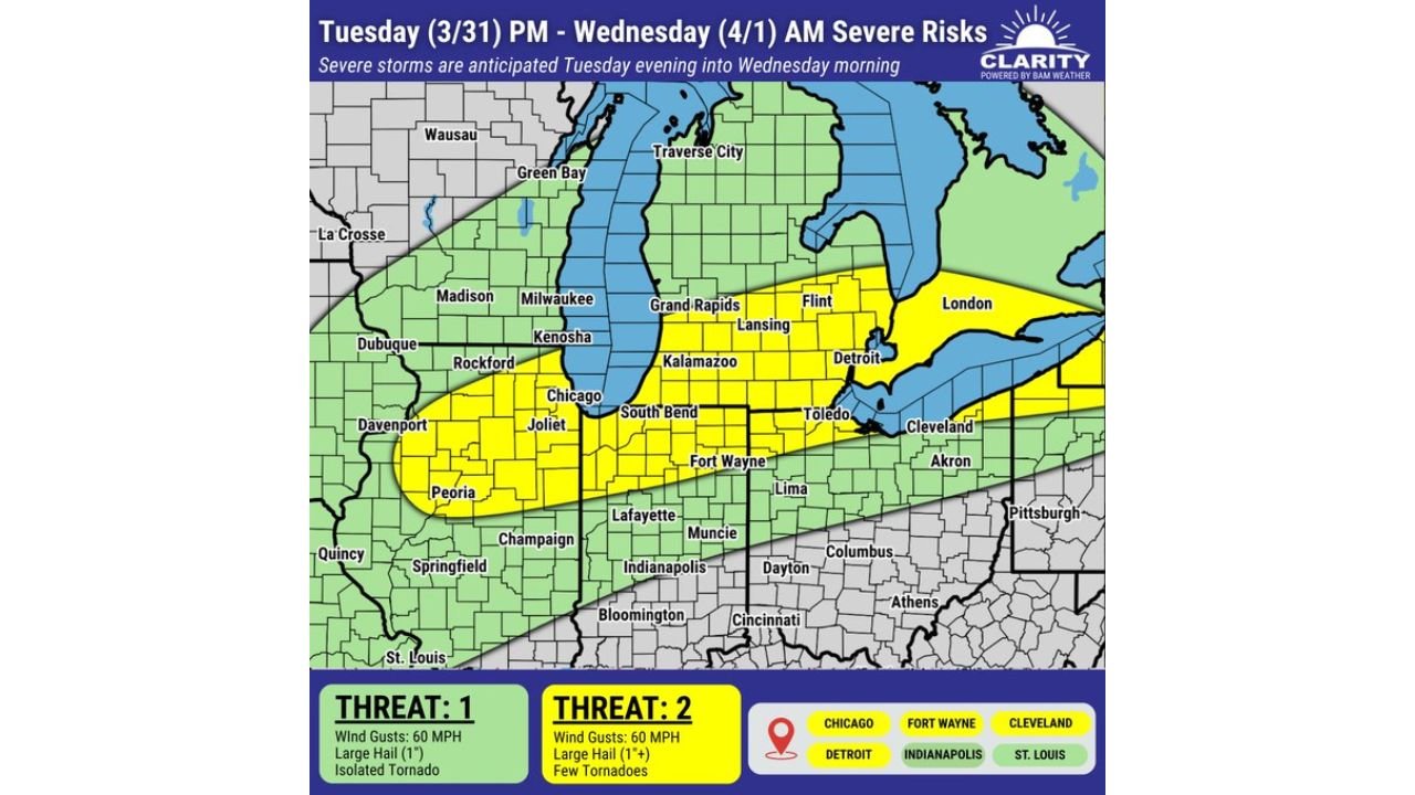
Second Round Builds Tuesday Afternoon Into Wednesday Morning
A more impactful round is expected to develop Tuesday afternoon and intensify into Tuesday night (March 31 into April 1).
This second system expands the threat zone across Illinois, Indiana, Michigan, and Ohio, including major cities such as Chicago, Fort Wayne, Detroit, Cleveland, and Indianapolis.
Unlike the first round, this phase is expected to be more surface-based, allowing storms to become stronger and more organized.
Damaging Winds and Tornado Risk Increase
With better instability and storm structure, the second round introduces a more significant severe threat.
Forecast guidance highlights wind gusts of 60 mph or higher and hail over 1 inch, along with the potential for a few tornadoes, especially within the stronger storm cells.
This marks a clear escalation compared to the overnight activity, with storms capable of producing more widespread impacts.
Storms Track East Across the Ohio Valley Overnight
As Tuesday night progresses, storms are expected to move eastward across Indiana into Ohio and toward parts of western Pennsylvania.
Cities like Cleveland and surrounding areas could see storms late at night into early Wednesday, extending the severe weather window beyond sunset once again.
The timing raises concerns for overnight impacts, particularly with stronger winds and isolated tornado potential.
Two-Stage Setup Increases Overall Risk Window
This two-round pattern significantly extends the duration of severe weather risk across the region.
The first round introduces hail and gusty winds overnight, while the second round brings a higher-end severe threat with damaging winds and tornado potential.
Residents across the Midwest and Great Lakes should remain alert from Monday evening through early Wednesday, as conditions may change quickly between each round.
Stay with CabarrusWeekly.com for continued updates, and share what conditions you are seeing in your area as these back-to-back storm systems move through.