This Week in History: The 1964 Alaska Good Friday Earthquake Remains the Second Largest Ever Recorded at Magnitude 9.2, Shaking Prince William Sound for 3 Minutes and Generating a Devastating Tsunami
PRINCE WILLIAM SOUND, ALASKA — Sixty-two years ago this week, the ground beneath southcentral Alaska did something that most people alive today have never experienced and hopefully never will. On March 27, 1964 at 5:36 PM local time, a magnitude 9.2 earthquake — the second largest ever recorded in human history — tore through Prince William Sound, Alaska, shaking the ground for an almost unimaginable three full minutes and unleashing destruction across one of the most remote yet populated stretches of the American frontier.
The event, known as the Good Friday Earthquake, remains the most powerful earthquake ever recorded in United States history and a defining moment in the science of seismology, tsunami research, and earthquake preparedness that continues to shape how America prepares for the next major seismic event today.
What Happened on March 27, 1964
At 5:36 PM on Good Friday, the Pacific Plate — which had been slowly grinding beneath the North American Plate along the Aleutian Trench for centuries — suddenly released an enormous amount of accumulated stress in one catastrophic rupture.
The earthquake lasted three minutes — an almost incomprehensible duration for anyone who has experienced even a brief earthquake. Most major earthquakes last between 10 and 30 seconds. Three minutes of continuous violent shaking is long enough for the human brain to fully process what is happening, for buildings to progressively fail, and for the ground itself to fundamentally change shape.
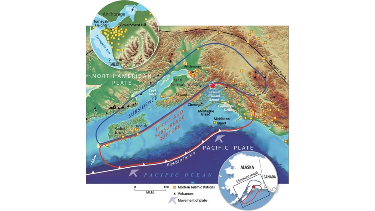
And that is exactly what happened. The rupture caused up to 15 meters of vertical displacement — meaning the ground in some areas literally rose or fell by nearly 50 feet in a matter of minutes. This displacement was not uniform. The earthquake created two distinct zones across southcentral Alaska that tell the story of how a subduction zone earthquake works.
Two Zones — Two Different Fates
The earthquake created a dramatic split in how different parts of southcentral Alaska were affected, defined by two zones visible in seismic records and geological surveys taken after the event.
The Subsidence Zone — covering the area around Anchorage, the Kenai Peninsula, Cook Inlet, and Kodiak Island — experienced the ground sinking during the earthquake. In some areas, land dropped several feet permanently, flooding coastal communities and changing the shoreline geography of southcentral Alaska forever. Anchorage bore the brunt of the structural destruction, with entire neighborhoods sliding into the sea as the soil liquefied and failed beneath them. The Turnagain Heights neighborhood — where homes slid into Knik Arm on massive blocks of earth — became one of the most iconic images of earthquake destruction in American history.
The Uplift and Subsurface Rupture Zone — centered directly over Prince William Sound and extending through the Copper River Delta, Montague Island, and Middleton Island — experienced the opposite effect. The seafloor and coastal land rose dramatically, with Montague Island lifting by as much as 30 feet in some locations. This uplift, happening rapidly beneath the ocean, was the mechanism that generated the tsunami.
The Tsunami That Followed
The 15 meters of vertical seafloor displacement in Prince William Sound displaced an enormous volume of ocean water almost instantaneously — generating a powerful tsunami that radiated outward across the Pacific Ocean.
The tsunami struck coastal Alaska communities with devastating force within minutes of the earthquake. Valdez, Seward, Kodiak, Chenega, and Whittier were all hit by waves that destroyed waterfronts, swept away buildings, and killed residents who had survived the shaking itself. Chenega lost a third of its entire population to the tsunami waves.
The tsunami traveled far beyond Alaska. It caused damage and deaths along the Oregon and California coasts — hitting Crescent City, California with particular severity and killing 11 people there. Waves were recorded as far away as Hawaii, Japan, and Antarctica.
Why This Matters Right Now
The 1964 Alaska earthquake is not just history. It is the most direct warning the United States has ever received about what the Cascadia Subduction Zone — the fault system running off the coasts of northern California, Oregon, Washington, and British Columbia — is capable of producing.
The same mechanism that caused the 1964 Alaska earthquake — a subduction zone where one tectonic plate dives beneath another — exists along the entire Pacific Northwest coastline. The Cascadia Subduction Zone is capable of producing an earthquake of magnitude 8.0 to 9.0 or greater, and the geological record shows it has done exactly that multiple times in the past, most recently in January 1700.
This week’s magnitude 7.3 earthquake near Vanuatu along the same Pacific Ring of Fire is a timely reminder that these massive fault systems are never truly quiet — they are always accumulating stress, always moving, always building toward the next major release.
Key Facts — 1964 Good Friday Earthquake
| Detail | Information |
|---|---|
| Date | March 27, 1964 |
| Time | 5:36 PM local time |
| Magnitude | 9.2 |
| Ranking | 2nd largest earthquake ever recorded |
| Location | Prince William Sound, Alaska |
| Shaking Duration | 3 minutes |
| Vertical Displacement | Up to 15 meters (nearly 50 feet) |
| Effects | Landslides, subsidence, uplift, tsunami |
| Tsunami Reach | Alaska, Oregon, California, Hawaii, Japan |
| US Ranking | Most powerful earthquake in US history |
What Americans Living in Seismic Zones Must Know
The 1964 earthquake fundamentally changed how the United States approaches earthquake and tsunami preparedness — but the job is never finished.
West Coast residents from California through Oregon and Washington live adjacent to the Cascadia Subduction Zone. A major Cascadia earthquake would trigger tsunamis reaching coastal communities within 15 to 30 minutes — leaving almost no time for official warnings to reach residents before waves arrive. Knowing your evacuation route and being able to self-evacuate immediately upon feeling strong shaking is the only reliable protection.
Alaska residents live directly on the most seismically active real estate in the United States. The same Aleutian Trench system that ruptured in 1964 continues to generate major earthquakes regularly. Structural earthquake preparedness — securing water heaters, anchoring bookshelves, knowing shelter-in-place procedures — is a daily reality for Alaskans.
Hawaii residents must maintain tsunami readiness year-round. The Pacific Ocean’s size does not protect Hawaii from tsunamis — it simply provides more warning time, typically several hours for distant earthquake tsunamis. Knowing Hawaii’s siren warning system and evacuation zones is essential.
Drop, cover, and hold on remains the correct action during earthquake shaking everywhere in the United States. Get under a sturdy table or desk, protect your head and neck with your arms, and hold on until all shaking has completely stopped before moving.
The Bottom Line
Sixty-two years ago this week, a magnitude 9.2 earthquake — the second largest ever recorded on Earth and the most powerful in United States history — struck Prince William Sound, Alaska, shaking the ground for three full minutes and generating a tsunami that killed Americans as far south as Crescent City, California. The 1964 Good Friday Earthquake remains the defining American seismic event and the clearest warning of what the Cascadia Subduction Zone along the Pacific Northwest coastline is capable of delivering. With the Pacific Ring of Fire producing a magnitude 7.3 earthquake near Vanuatu just this week, the reminder could not be more timely — America’s seismic risk is real, it is ongoing, and preparedness is not optional.
Stay ahead of natural disasters and breaking seismic events before they impact your area. Visit cabarrusweekly.com for breaking earthquake coverage, tsunami alerts, and natural disaster updates from across the United States — because knowing early is the difference that matters.