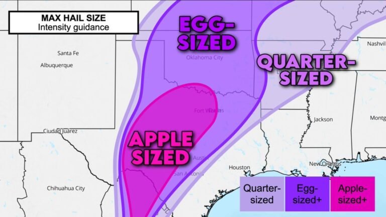
Southwest Oklahoma and North Texas Face Tennis Ball Size Hail, Damaging Gusts and Isolated Tornadoes Monday as Dryline Storms Attempt Cap Break
SOUTHWEST OKLAHOMA AND NORTH TEXAS — A dangerous severe weather setup is developing along the dryline in southwest Oklahoma and north Texas on Monday, May 5, 2026, with storm initiation increasingly plausible as models show convection firing near Lawton, Burkburnett, Walters and Wichita Falls — bringing a threat of tennis ball size hail, damaging wind gusts and isolated tornadoes if storms can break the atmospheric cap.
The Cap Is the Key — And Breaking It Looks Increasingly Likely
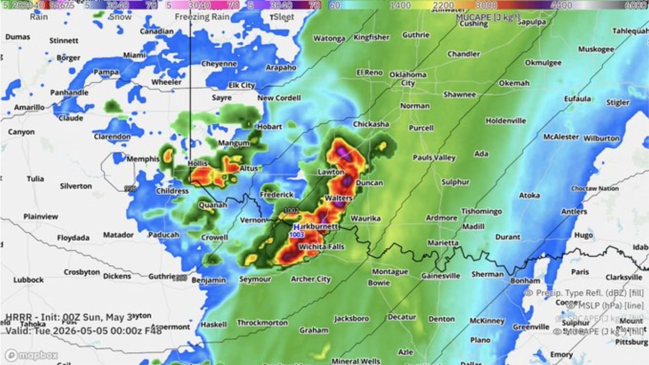
The entire Monday severe weather threat hinges on whether storms can punch through a capping inversion. As of Sunday, cap break appears increasingly plausible across southwest Oklahoma. Model data shows storm initiation signals near Burkburnett and the Lawton to Walters corridor by Tuesday, May 5 at 00Z, with reflectivity and CAPE values concentrated tightly in that zone.
The sounding data valid Monday, May 4 at 23Z for the 34.32N, 98.19W location shows surface-based CAPE values of 2162 m²/s², storm relative helicity of 269 m²/s², and a well-defined LCL and LFC structure supporting supercell development if initiation occurs.
Hazards If Cap Breaks Monday
- Hail — up to tennis ball size
- Wind — damaging gusts
- Tornado — a tornado or two possible
Storm Initiation Zone
Both model runs show the most intense convective signal tightly clustered near Burkburnett, Walters, Vernon and the Frederick to Lawton corridor across southwest Oklahoma and the Texas border counties. MUCAPE values across central and eastern Oklahoma remain elevated, supporting storm sustenance if development occurs.
Forecast Confidence Remains Conditional
This remains a conditional severe weather threat. Storms must first break the cap before any hazards materialize. Forecasters are monitoring the situation closely and will refine the outlook through Sunday as confidence increases on initiation timing.
Residents across southwest Oklahoma and north Texas should keep alerts active Monday afternoon and have a shelter plan ready before storms arrive.
Stay with CabarrusWeekly.com for updated severe weather forecasts across southwest Oklahoma and north Texas as Monday’s setup becomes clearer.