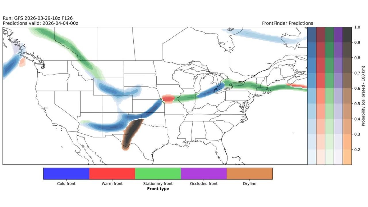
Cold Front, Dryline, and Stationary Front Set Up Across the Central Plains, Great Lakes, and Northeast Friday Evening April 3 as Active Pattern Continues to Drive Severe Weather Risk From Texas and Oklahoma Through Pennsylvania and New York
UNITED STATES — A complex and potentially significant frontal boundary setup is taking shape across a large portion of the United States for Friday evening, April 3, 2026. A cold front dropping through the central Plains, a dryline developing over Texas and Oklahoma, and a stationary front stretching from the Great Lakes through the Northeast are all forecast to be in place simultaneously — a combination that historically signals active and potentially severe weather across multiple regions of the country.
This forecast is based on the GFS model run from March 29, 2026 at 18z, valid Friday, April 4, 2026 at 00z — representing Friday evening conditions across the United States.
Three Frontal Boundaries — Three Distinct Threats
What makes Friday evening’s setup particularly noteworthy is not any single frontal boundary — it is the simultaneous presence of three distinct weather boundaries across different parts of the country, each capable of driving its own area of active weather independently.
When multiple frontal systems are active at the same time, they can interact with each other and with the Gulf moisture already surging northward — creating a more complex and potentially more dangerous severe weather environment than any single boundary would produce on its own.
The Cold Front — Central Plains
A well-defined cold front is forecast to be dropping southeastward through the central Plains by Friday evening, oriented roughly from the Kansas and Oklahoma corridor down toward the Texas Panhandle.
Cold fronts are the most common trigger for severe thunderstorm development across the Plains. As the front pushes into warm, moist Gulf air ahead of it, the contrast between the cold dry air behind the front and the warm humid air ahead creates a sharp instability boundary. Storms that fire along or just ahead of this cold front Friday evening will have access to the deep Gulf moisture already in place across Oklahoma, Kansas, Arkansas, and Missouri — meaning any storms that develop along this boundary carry the potential to become strong to severe quickly.
The cold front’s position over the central Plains on Friday places it directly in line with the active weather corridor that has been building all week — making Friday one of the more significant severe weather days of an already very active early April pattern.
The Dryline — Texas and Oklahoma
Directly behind and feeding into the cold front setup is a dryline — one of the most important and underappreciated weather boundaries in American meteorology — developing over Texas and Oklahoma Friday evening.
A dryline is a boundary separating extremely dry air pushing eastward from the desert Southwest from warm, moist Gulf air streaming northward from the Gulf of Mexico. Along this boundary, the contrast between air masses can be dramatic — humidity can jump from 15 percent on the dry side to 65 percent on the moist side within just a few miles.
This sharp moisture contrast is the classic ignition point for supercell thunderstorm development across the southern Plains. When upper-level winds provide sufficient wind shear and instability values are high — both of which are expected Friday across Texas and Oklahoma — storms firing along the dryline can rapidly organize into rotating supercells capable of producing large hail, damaging winds, and tornadoes.
The dryline’s presence on Friday alongside the cold front creates a convergence zone across the Texas and Oklahoma area that deserves serious attention as the week develops.
The Stationary Front — Great Lakes Through the Northeast
Stretching in a completely different direction — from the Great Lakes eastward through Pennsylvania, New York, and into New England — a stationary front is forecast to be draped across the northern tier of the eastern United States Friday evening.
A stationary front, as the name suggests, is a frontal boundary that is not moving significantly in either direction. It sits and lingers — and as it does, it becomes a focal point for repeated rounds of rain and storm development. Warm moist air rising over the front generates prolonged precipitation on the warm side of the boundary, while the front itself acts as a trigger for storm development when upper-level energy passes over it.
The stationary front’s position across the Great Lakes and Northeast on Friday explains why the broader early April pattern has been signaling above normal rainfall across this corridor. A front that parks itself from Chicago and Detroit through Cleveland, Pittsburgh, Philadelphia, and into New England is a recipe for multi-day rainfall accumulations and elevated flood risk across the Ohio Valley and Mid-Atlantic.
The Warm Front — Iowa and Missouri
A smaller but meteorologically significant warm front is also forecast over Iowa and Missouri Friday evening — positioned between the cold front to the southwest and the stationary front to the northeast.
Warm fronts are often where the most intense precipitation and storm development occurs ahead of an approaching cold front. As warm, moist air rises rapidly over the warm front boundary, it can generate heavy rainfall rates and, when wind shear is sufficient, organized thunderstorm activity. The warm front’s position over Iowa and Missouri places it squarely in the corridor between two larger boundaries — making it a potential focal point for storm initiation across the upper Midwest Friday afternoon and evening.
Frontal Boundary Summary — Friday Evening April 3
| Boundary | Location | Primary Threat |
|---|---|---|
| Cold Front | Kansas / Oklahoma / Texas Panhandle | Severe thunderstorms, damaging winds, hail |
| Dryline | Texas / Oklahoma | Supercell development, large hail, tornadoes |
| Warm Front | Iowa / Missouri | Heavy rain, storm initiation |
| Stationary Front | Great Lakes through Northeast | Prolonged rain, flooding, storm development |
Forecast Confidence Level
High confidence on the overall frontal boundary positions Friday evening — the GFS model has been consistent across multiple runs on the placement of each boundary.
High confidence on the dryline and cold front combination over Texas and Oklahoma as the primary severe weather focus Friday — this setup is well-supported by multiple model runs.
Medium confidence on exact storm coverage and intensity** — the degree to which storms organize along each boundary will depend on surface heating, moisture depth, and upper-level wind shear values that will become clearer by Wednesday and Thursday.
High confidence on prolonged rainfall along the stationary front across the Great Lakes and Northeast — a stationary front in this position historically produces multi-day rainfall events across the Ohio Valley and Mid-Atlantic.
What Residents in Each Zone Must Know Before Friday
Texas and Oklahoma residents face the highest severe weather potential Friday evening. The combination of a cold front and dryline in the same area — with deep Gulf moisture already in place — is one of the most dangerous setups in the meteorological playbook. Have a severe weather plan finalized before Friday afternoon and monitor updated outlooks Wednesday and Thursday as the Storm Prediction Center refines the risk area.
Kansas, Missouri, Arkansas, and Iowa residents sit in the warm sector ahead of the cold front Friday — meaning storms that fire to the southwest can move into these states during the evening hours. Stay weather aware throughout Friday afternoon and evening.
Ohio, Indiana, Michigan, Pennsylvania, and New York residents should expect prolonged rain and possible storm activity along and near the stationary front through the end of the week. Flood-prone areas should monitor river levels and drainage conditions closely as the cumulative rainfall from the week continues to build.
New England residents — the stationary front extends into your region as well. Heavy rainfall is possible across Connecticut, Massachusetts, Rhode Island, Vermont, New Hampshire, and Maine as the front lingers through the end of the week.
The Bottom Line
Friday evening, April 3 brings a complex and potentially significant multi-boundary frontal setup across the United States. A cold front and dryline over Texas and Oklahoma signal a serious severe weather threat across the southern Plains, while a stationary front draped from the Great Lakes through the Northeast drives prolonged rainfall and flooding concerns across the Ohio Valley and Mid-Atlantic. A warm front over Iowa and Missouri adds another storm trigger to an already active pattern. This is the culmination of a week-long active weather pattern that has been building since Monday — and Friday may be the most significant day yet. Monitor updated forecasts daily through Thursday as confidence increases on the exact severe weather risk areas.
Stay ahead of dangerous weather before it reaches your door. Visit cabarrusweekly.com for daily severe weather coverage, frontal system tracking, and storm alerts from across the United States — because knowing early is the difference that matters.