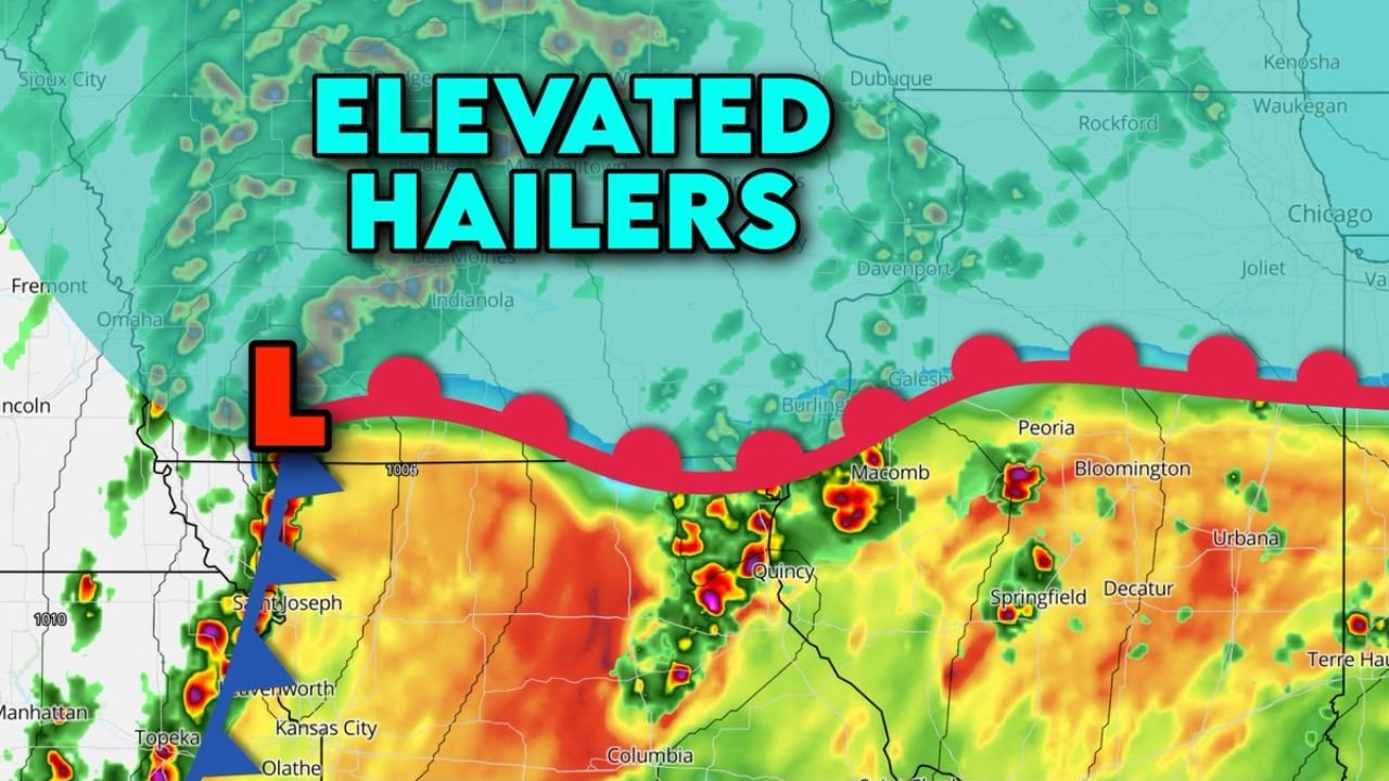
Iowa and Northern Illinois Face Elevated Hail Threat as Storms Ride North of Warm Front With Limited Tornado Risk
IOWA AND NORTHERN ILLINOIS — A distinct severe weather setup is unfolding across the region, where storms developing north of a warm front are expected to produce primarily hail rather than tornadoes, especially across northern Iowa into parts of northern Illinois.
Elevated Storms Develop North of Warm Front
The key feature driving this setup is a warm front stretching across the Midwest, with cooler air sitting at the surface north of that boundary.
Storms forming in this region are considered “elevated,” meaning they are rooted above the surface layer rather than directly at ground level. This limits their ability to produce tornadoes but still allows for strong storm development.
Hail Becomes the Primary Threat
Because these storms are riding above a shallow layer of cool air, they are more likely to produce large hail as their main hazard.
The atmospheric structure supports strong updrafts aloft, which can keep hailstones suspended longer, allowing them to grow in size before falling. Areas across northern Iowa, including regions near the Iowa–Missouri border and extending east toward Illinois, are most likely to see this elevated hail threat.
Reduced Tornado Potential in Northern Zone
Unlike areas farther south, where storms are surface-based, the setup here significantly reduces the tornado risk.
With storms not fully connected to surface-level instability, the ingredients needed for tornado development are limited, making hail and heavy rain the dominant concerns instead.
Active Storm Corridor Extends Into Illinois
Storms are expected to track eastward along the warm front, bringing periods of heavy rain, lightning, and hail into parts of northern Illinois, including areas near Peoria, Bloomington, and surrounding regions.
While storms may intensify at times, their elevated nature keeps the overall severe risk focused on hail rather than widespread wind damage or tornadoes.
A Split Severe Weather Pattern Across the Region
This setup highlights a classic contrast in severe weather types. Areas south of the warm front may deal with tornado and wind risks, while areas to the north — including much of Iowa — face a hail-driven storm threat.
Understanding this difference is critical, as impacts can vary significantly over relatively short distances.
Residents across Iowa and northern Illinois should remain alert for developing storms, especially during the afternoon and evening hours when hail-producing storms are most likely.
If you experience hail or severe weather in your area, share your reports with CabarrusWeekly.com to help others stay informed.