Pennsylvania and Ohio Brace for Intense Evening Storm Line Bringing 60+ MPH Winds From Cleveland to Erie Between 5 PM and 8 PM
PENNSYLVANIA — A potentially dangerous line of thunderstorms is expected to develop and push into the region later today, with northwestern Pennsylvania and parts of northeastern Ohio directly in the path of the strongest impacts.
Intense Storm Line Targeting Northwestern Pennsylvania This Evening
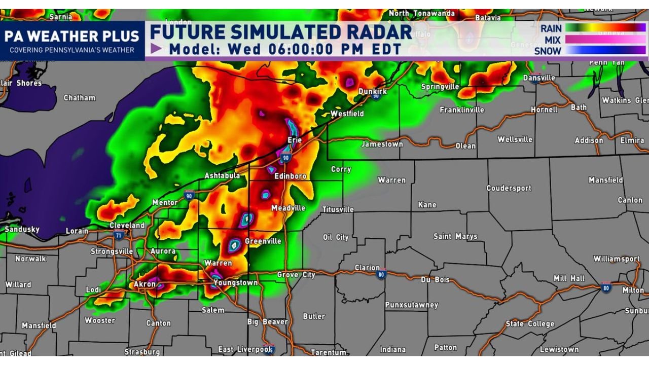
Latest high-resolution model guidance shows a well-organized line of storms forming and advancing eastward, reaching areas from Cleveland and Akron through Youngstown and into Erie, Pennsylvania during the early evening hours.
The most critical timing window appears to be between 5 PM and 8 PM, when storms are expected to intensify as they move into northwestern Pennsylvania, including cities like:
- Erie
- Edinboro
- Meadville
- Greenville
Storms Could Pack Damaging Winds and Heavy Rain
If atmospheric conditions become sufficiently unstable through the day, these storms could strengthen into a powerful line capable of producing significant impacts.
The main threats include:
- Damaging wind gusts exceeding 60 MPH
- Torrential downpours, leading to localized flooding
- Frequent lightning, posing risks for outdoor activities
Radar projections show a solid, intense line structure, which typically increases the likelihood of widespread wind damage rather than isolated impacts.
Why Instability Will Be Key
The overall severity of this event will depend heavily on how much clearing and warming occurs during the morning and early afternoon.
- More sunshine = greater instability = stronger storms
- Limited clearing could keep storms somewhat less intense, but still impactful
This means conditions could change quickly, and even a small increase in instability may lead to a noticeable jump in storm intensity.
Storm Movement and Progression
Storms are expected to track from west to east, beginning in northeastern Ohio before moving into Pennsylvania.
Key progression areas include:
- Cleveland → Akron → Youngstown → Erie corridor
- Expanding into inland northwestern Pennsylvania communities by evening
Residents along and north of the Interstate 90 corridor may experience the most concentrated impacts as the line moves through.
What Residents Should Prepare For
People in the affected areas should be ready for:
- Rapidly changing weather conditions during the evening commute
- Sudden strong wind gusts capable of causing damage
- Reduced visibility in heavy rain
- Lightning risks for outdoor plans
It’s important to secure loose outdoor items and stay alert for weather warnings, especially as storms approach your location.
Bottom Line
An intense, fast-moving line of storms is expected to impact northwestern Pennsylvania this evening, with Erie and surrounding areas facing the highest risk between 5 PM and 8 PM. With 60+ MPH winds, heavy rain, and lightning all possible, this system has the potential to disrupt travel and evening activities.
Stay with CabarrusWeekly.com for real-time updates as this developing storm line moves into the region.