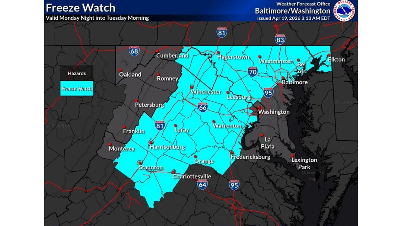
Freeze Watch Issued West of I-95 as Washington DC Area Temperatures Plunge to 29 Degrees Tuesday Morning
WASHINGTON, D.C. — Temperatures across the greater Washington D.C. and Baltimore region are crashing 30 to 40 degrees colder than just 24 hours ago, and the dangerous cold is not done yet — a Freeze Watch is now in effect for areas west of I-95 from 2:00 AM to 10:00 AM Tuesday, with lows forecast to drop as low as 29 to 32 degrees across a wide swath of the region.
Freeze Watch Valid Monday Night Into Tuesday Morning
The National Weather Service Baltimore/Washington office issued the Freeze Watch covering a broad corridor stretching from the Shenandoah Valley through the northern Virginia and Maryland suburbs. Cities directly under the watch include Winchester, Leesburg, Warrenton, Harrisonburg, Staunton, Charlottesville, Hagerstown, Westminster, Frederick, and Culpeper.
The watch is valid from Monday night through Tuesday morning, April 22, representing a hard freeze threat that could damage or kill vegetation across the affected zone.
Lowest Temperatures Expected Across the Region Tuesday
Low temperature forecast data for Tuesday morning shows just how widespread and severe the cold will be:
| City | Forecast Low |
|---|---|
| Hagerstown / Martinsburg / Winchester | 29°F |
| Frederick / Charles Town / The Plains | 29 to 30°F |
| Culpeper / Waterloo / Sperryville | 29°F |
| Fairfax / Manassas | 33 to 34°F |
| Washington D.C. | 34°F |
| Baltimore | 36°F |
| Annapolis | 38°F |
| Fredericksburg | 32°F |
Inside the Beltway Stays Above Freezing but Frost Still Possible
Areas inside the Beltway and to the east are expected to remain just above the freezing mark, with lows generally in the mid to upper 30s. However, scattered frost is still possible across these areas, particularly on exposed surfaces and in low-lying areas where cold air pools overnight.
Freeze Up to 10 Days Later Than Normal — Plants at Risk
This freeze is occurring up to 10 days later than the typical last freeze date for the region, meaning vegetation has already advanced well into its spring growth cycle. Sensitive plants, garden flowers, and early crops are particularly vulnerable. Sensitive plants should be brought inside or covered before Monday night to avoid freeze damage.
Stay with CabarrusWeekly.com for live freeze and temperature updates across the Washington D.C. and Baltimore region through Tuesday morning.