Dry Conditions Lock In Across the Central US Through Wednesday With Heavy Rain Soaking Texas Gulf Coast
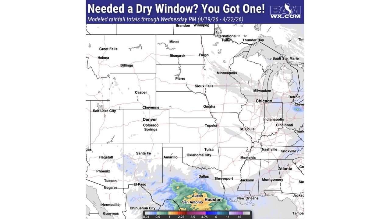
UNITED STATES — High pressure is taking firm control across the heart of the country, delivering a critical dry window from Sunday April 19 through Wednesday evening April 22 across most of the Central and Eastern United States — while heavy rainfall simultaneously hammers the Texas Gulf Coast with totals pushing well above 4 inches.
Nearly the Entire Central US Goes Dry Through Wednesday
Modeled rainfall totals through Wednesday evening April 22 show an almost completely dry map across a massive corridor stretching from the Northern Plains and Rockies through the Midwest, Ohio Valley, and into the Southeast. Cities including Denver, Omaha, Kansas City, St. Louis, Chicago, Indianapolis, Nashville, and Atlanta are all sitting under essentially zero rainfall accumulation through mid-week.
This dry stretch represents a valuable window for agricultural operations across the Plains and Midwest, where fieldwork and planting activity can proceed without weather interruption through at least Wednesday.
Texas Gulf Coast Takes the Hit With 4 to 11 Inches of Rain
While the interior stays dry, the Texas Gulf Coast is absorbing a significant rainfall event during this same period. Modeled totals show Houston, Austin, and San Antonio in line for 4 to over 11 inches of rainfall through Wednesday evening, with the heaviest totals concentrated along and near the coast. Localized amounts could be even higher within the heaviest training thunderstorm bands.
| Region | Projected Rainfall Through Wednesday PM |
|---|---|
| Northern and Central Plains | Trace to 0.01 inches |
| Midwest and Ohio Valley | Dry — near zero |
| Southeast and Tennessee Valley | Trace amounts only |
| Texas Gulf Coast (Houston area) | 4 to 11+ inches |
| South Texas (San Antonio/Austin) | 2.25 to 6+ inches |
Rain and Storms Return Thursday
The dry window is temporary. As high pressure slides east, moisture and storm energy return to the central United States beginning Thursday, ending the brief quiet spell across the Plains and Midwest. Timing and coverage of Thursday’s storm activity will become clearer as the week progresses.
Agricultural Window Closing Fast
For farming operations from the Plains through the Corn Belt, the next three days represent the best opportunity for fieldwork before the next round of rain arrives. Producers should take full advantage of this dry stretch before conditions change Thursday.
Stay with CabarrusWeekly.com for rainfall and storm return timing updates across the Central United States through the week.