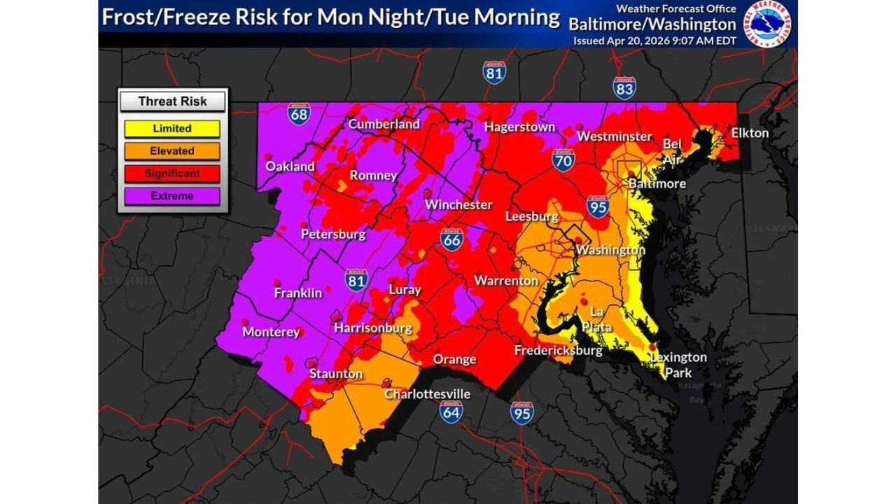
Freeze Warning Grips the Washington DC and Baltimore Region Tonight With Lows Crashing to 27 Degrees by Tuesday Morning
WASHINGTON, DC — A Freeze Warning is in effect tonight across the entire Washington DC and Baltimore region through Tuesday morning April 21, with lows forecast to plunge as low as 27 degrees across areas north and west of the Beltway — arriving 5 to 10 days later than normal for many locations and threatening crops and plants that are already well ahead of their typical growth schedule.
Hardest Hit — Areas Outside the Beltway Away From Water
The coldest temperatures tonight will occur across areas outside the Beltway and away from moderating water bodies. Lows of 27 to 33 degrees are probable north and west of the Beltway, covering communities including Cumberland, Hagerstown, Winchester, Harrisonburg, Staunton, Charlottesville, Luray, Warrenton, and Fredericksburg. South and east of the Beltway, lows of 28 to 34 degrees are expected across areas including Westminster, Bel Air, and La Plata.
Inside the Beltway — Flirting With Freezing
Areas inside the Beltway but away from dense urban zones face lows of 31 to 35 degrees tonight, placing them right at or just above the freezing threshold. Scattered frost is possible across these areas, particularly on exposed vegetation, car rooftops, and open grassy surfaces.
Urban Zones and Waterfront Areas Likely Stay Above Freezing
The warmest overnight lows tonight will occur across urban zones inside the Beltway and along the Potomac River and Chesapeake Bay, where the urban heat island effect and water temperature moderating influence keep lows in the 33 to 38 degree range — likely staying just above a hard freeze.
| Zone | Expected Low | Freeze Risk |
|---|---|---|
| North and west of Beltway | 27 to 33°F | Hard freeze certain |
| South and east of Beltway | 28 to 34°F | Hard freeze likely |
| Inside Beltway, non-urban | 31 to 35°F | Frost likely, freeze possible |
| Urban zones and waterfront | 33 to 38°F | Likely stays above freezing |
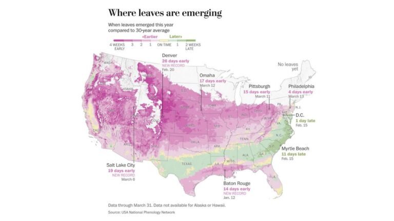
Plants and Crops at Serious Risk After Warmest Spring on Record
Following one of the warmest springs on record across the region, crops and plants across the DC and Baltimore area are growing significantly ahead of their typical seasonal schedule. This makes tonight’s freeze particularly dangerous for vegetation — a hard freeze hitting already-advanced plant growth can cause severe and irreversible damage to flowers, garden crops, fruit trees, and ornamental plants.
The National Weather Service noted this freeze could be rather impactful given how far ahead of schedule spring growth has progressed. Cover or bring inside all sensitive plants before tonight if at all possible.
Stay with CabarrusWeekly.com for live freeze warning and temperature updates across the Washington DC and Baltimore region through Tuesday morning.