Dulles Airport Shatters 1983 Record Low as DC Region Plunges to 25 Degrees Tuesday Morning Damaging Early Spring Crops
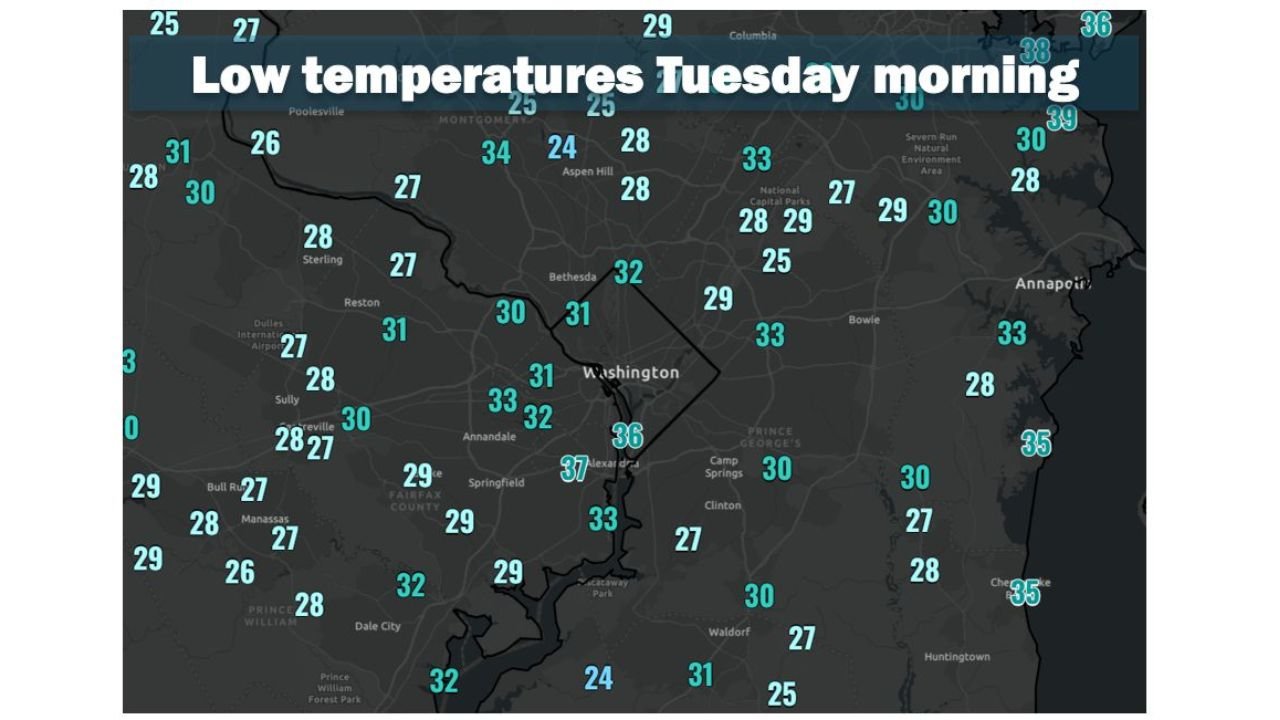
WASHINGTON, DC — A punishing freeze swept through the Washington DC region Tuesday morning, driving temperatures into the mid-20s to mid-30s across the metro area and shattering a 43-year-old record low at Washington Dulles International Airport — with the late-season cold arriving 5 to 10 days later than normal and threatening serious damage to crops and vegetation already well into their spring growth cycle.
Dulles Breaks 1983 Record — Drops to 27 Degrees
Washington Dulles International Airport recorded a low of 27 degrees Tuesday morning, breaking the previous calendar day record of 29 degrees set in 1983. Reagan National Airport bottomed out at 36 degrees, while Baltimore-Washington International Marshall Airport fell to 30 degrees — all registering well below freezing or on the edge of it during the overnight hours.
Mid-20s Gripped Areas Outside the Beltway
The coldest readings of the morning were concentrated across areas outside the Beltway and away from water bodies. Observed lows across the DC suburbs included some striking numbers:
| Location | Tuesday Morning Low |
|---|---|
| Dulles International Airport | 27°F — Record |
| Manassas / Bull Run area | 26 to 28°F |
| Sterling / Reston | 27 to 31°F |
| Poolesville / Montgomery area | 25 to 27°F |
| Dale City / Prince William | 28 to 32°F |
| Washington DC | 32 to 36°F |
| Alexandria | 37°F |
| Annapolis / Chesapeake | 33 to 35°F |
| Bowie / Camp Springs | 27 to 30°F |
Inside the Beltway and Waterfront Areas Stayed in the 30s
The urban core of Washington DC and Alexandria held in the low to mid-30s due to the urban heat island effect, while areas along the Potomac River and Chesapeake Bay also remained in the low to mid-30s thanks to the moderating influence of open water. These zones largely avoided a hard freeze but still recorded some of the coldest April temperatures in years.
Crops at Serious Risk After Abnormally Warm Spring
The timing of this freeze is particularly damaging. Following an abnormally warm March and April, vegetation and crops across the region entered an unusually advanced stage of spring growth — leaving them highly vulnerable to exactly this type of late freeze event. The cold arrived 5 to 10 days later than the typical last freeze date for many locations, meaning plants that would normally be protected by dormancy were fully exposed.
Fruit trees, garden crops, ornamental flowers, and early-season agricultural products across the DC metro region may have suffered significant and potentially season-ending freeze damage from Tuesday morning’s record cold.
Stay with CabarrusWeekly.com for continuing freeze damage and temperature recovery updates across the Washington DC and Baltimore region.