Dangerous Squall Line With 55 to 65 MPH Gusts and Tornado Risk Targets Western Pennsylvania This Afternoon
WESTERN PENNSYLVANIA — A powerful cold front is charging into western Pennsylvania this afternoon, colliding with warm and humid air already in place to spark the risk of a strong to severe squall line capable of producing 55 to 65 MPH damaging wind gusts, torrential rainfall, frequent lightning, and an isolated tornado threat across the region.
Cold Front and Wind Shear Organize Storms Into a Squall Line
Increasing wind shear ahead of the approaching cold front is helping to organize storm cells into a cohesive squall line rather than scattered individual storms. This organization significantly raises the threat for widespread damaging winds along a concentrated corridor pushing through western Pennsylvania this afternoon.
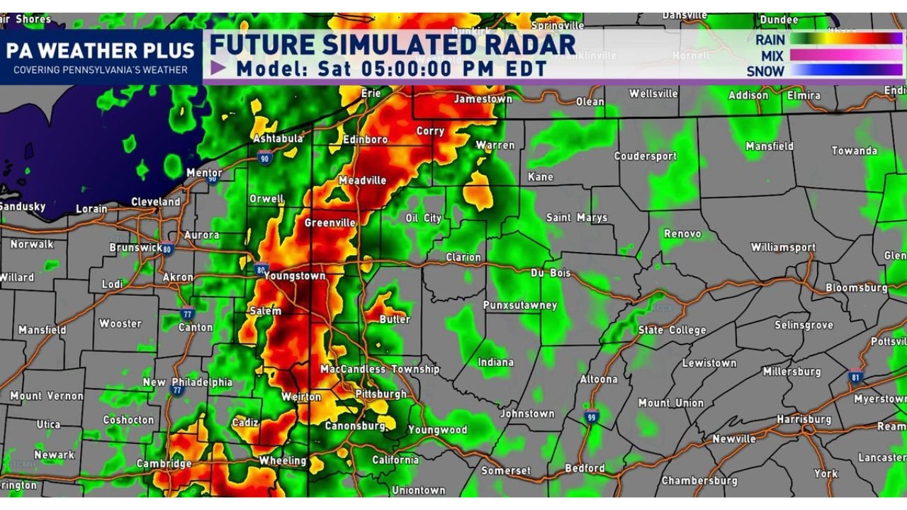
Simulated radar valid at 5:00 PM EDT shows a well-defined line of intense precipitation — with deep red and orange cores — sweeping through Pittsburgh, Greenville, Meadville, Butler, Canonsburg, and Youngstown and continuing eastward toward Indiana and Punxsutawney.
55 to 65 MPH Winds, Torrential Rain and Lightning All Likely
The squall line is expected to produce three primary hazards as it moves through:
Wind gusts of 55 to 65 MPH are the primary threat, capable of downing trees and power lines across a wide area. Torrential rainfall will accompany the line, with heavy downpours reducing visibility rapidly. Frequent lightning is also expected throughout the event.
| Hazard | Threat Level |
|---|---|
| Wind Gusts | 55 to 65 MPH |
| Rainfall | Torrential |
| Lightning | Frequent |
| Tornado | Isolated, cannot be ruled out |
Isolated Tornado Cannot Be Ruled Out
Directional wind shear near the surface introduces a low but real tornado threat within the squall line. The shear is sufficient to allow for some spin within the line, making an isolated weak tornado possible as the system pushes through this afternoon.
Pittsburgh and Surrounding Areas in the Bull’s-Eye
Cities directly in the path of the most intense radar returns include Pittsburgh, Greenville, Meadville, Butler, Weirton, and Canonsburg. Areas further east including Johnstown, Altoona, and State College should remain on alert as the line tracks eastward through the afternoon and evening hours.
Stay with CabarrusWeekly.com for live severe weather updates across western Pennsylvania this afternoon.