Six Straight Days of Severe Weather Outlined Wednesday Through Monday From the High Plains to the Deep South
UNITED STATES — The Storm Prediction Center has now outlined severe weather risk areas for six consecutive days — Wednesday April 22 through Monday April 27, 2026 — as one of the most sustained and widespread severe weather stretches of the 2026 spring season gets underway, with the threat corridor shifting progressively eastward from the central High Plains all the way through the Deep South and Tennessee Valley by next week.
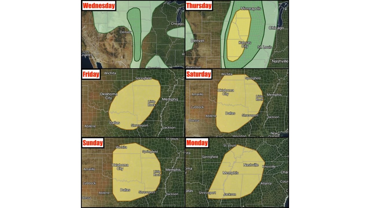
Wednesday — Hail and Wind Along the Dakotas to Texas Dryline
Wednesday’s severe weather threat kicks off the sequence along a developing dryline stretching from the Dakotas southward through Texas. High-based storms with a low-end large hail and damaging wind risk are the primary concerns Wednesday, with moisture still limited at this early stage of the pattern. A marginal risk zone also clips portions of the upper Midwest near Chicago.
Thursday — All Hazards Possible From Minneapolis to Kansas City
Thursday brings a significant escalation. Improved moisture ahead of the dryline and stronger forcing for ascent combine to produce a more widespread severe weather day across a corridor from Minneapolis and Chicago southward through Kansas City and St. Louis. All hazard types are possible Thursday, though wind profiles may lead to a complex and messy storm mode with multiple interactions rather than discrete organized supercells.
Friday — Oklahoma City to Little Rock and Shreveport
Friday’s risk zone shifts southeastward, covering Oklahoma City, Little Rock, Dallas, and Shreveport as the front continues its eastward progression. The Friday setup carries potential for robust severe weather within the outlined risk area, though some model discrepancy still exists on specific storm details.
Saturday — Expanded Risk From Amarillo to Memphis and Jackson
Saturday’s risk area is notably large, stretching from Amarillo and Lubbock through Oklahoma City, Dallas, Shreveport, Little Rock, Memphis, and Jackson. This represents one of the broader single-day risk footprints of the entire sequence and suggests widespread storm coverage across the Southern Plains and Mid-South.
Sunday — Oklahoma City to Little Rock and Dallas Corridor
Sunday maintains the threat across a similar corridor to Friday and Saturday, keeping Oklahoma City, Little Rock, Dallas, Shreveport, and Jackson in play for another round of organized severe weather as the second and reportedly more potent storm system begins affecting the region.
Monday — Nashville to Memphis, Atlanta and the Deep South
Monday’s risk zone shifts the most dramatically eastward, pushing into Nashville, Knoxville, Memphis, Atlanta, and the surrounding Deep South and Tennessee Valley as a powerful cold front drives into the region. Monday currently appears to be one of the biggest days of the entire sequence, with a rare Day 7 outlook already issued for this event.
| Day | Primary Risk Zone | Key Cities |
|---|---|---|
| Wednesday Apr 22 | High Plains dryline | Denver corridor, Dakotas to Texas |
| Thursday Apr 23 | Central Plains to Midwest | Minneapolis, Kansas City, St. Louis |
| Friday Apr 24 | Southern Plains to Mid-South | OKC, Little Rock, Dallas, Shreveport |
| Saturday Apr 25 | Expanded Southern Plains | Amarillo, OKC, Dallas, Memphis, Jackson |
| Sunday Apr 26 | Southern Plains core | OKC, Little Rock, Dallas, Shreveport |
| Monday Apr 27 | Deep South and TN Valley | Nashville, Memphis, Atlanta, Knoxville |
Pattern May Remain Active Beyond Monday
Forecasters note that the severe weather pattern carries the potential to remain active beyond Monday, with the atmospheric setup not showing clear signs of shutting down after the six-day sequence concludes. Residents across the entire central and southern United States should treat this as an extended high-alert period and monitor forecasts closely every single day from Wednesday through at least the end of April.
Stay with CabarrusWeekly.com for daily severe weather outlook updates across the Plains, Mid-South, and Deep South through Monday April 27 and beyond.