Strong Storms With Gusty Winds and Hail to Pop Up Across Southern Michigan Northern Indiana and Northern Ohio This Evening
SOUTHERN MICHIGAN — A messy area of rain and storms pushing southeastward through the Great Lakes region this morning is giving way to a second round of pop-up storm development expected this afternoon and evening across southern Michigan, northern Indiana, and northern Ohio — with a few strong storms capable of gusty winds and small hail possible during the evening hours.
Morning Storm Activity Shifting Southeast Through Ohio and Indiana
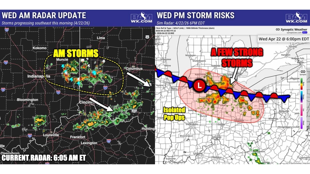
Current radar valid 6:05 AM ET Wednesday April 22 shows an active area of showers and thunderstorms across a zone from Kokomo and Muncie through Columbus and Cincinnati, with the complex continuing to push southeastward through the morning. Lightning and orange-shaded radar returns indicate moderate to locally heavy rainfall within the moving complex across central Indiana and western Ohio.
This morning round is expected to shift away from the region through the late morning and midday hours before the afternoon threat develops.
Evening Storm Risks Focused on Southern Michigan and Northern Ohio
By Wednesday evening around 6:00 PM EDT, forecast storm risk data shows a concentrated red-shaded strong storm zone centered across southern Michigan — including the Kalamazoo and Ann Arbor corridor — and extending eastward into northern Ohio near Cleveland and the surrounding region. A low pressure center positioned along the frontal boundary is driving the evening storm development directly into this corridor.
Isolated pop-up storm activity is also possible across a broader surrounding zone including northern Indiana and portions of the Ohio Valley, though the most organized and strongest storm potential is focused on the southern Michigan and northern Ohio red-zone area.
Gusty Winds and Small Hail the Primary Threats This Evening
Thursday’s evening storm complex is not expected to produce the widespread severe weather associated with the larger outbreak further west, but a few strong storms within the red zone carry the potential for:
| Hazard | Threat Level |
|---|---|
| Gusty winds | Possible with stronger cells |
| Small hail | Possible |
| Heavy rainfall | Likely with storm clusters |
| Tornado risk | Not the primary concern |
Residents across Kalamazoo, Ann Arbor, Cleveland, and surrounding southern Michigan and northern Ohio communities should remain weather-aware through the evening hours and be prepared to take shelter quickly if a strong storm approaches.
Stay with CabarrusWeekly.com for live storm updates across southern Michigan, northern Indiana, and northern Ohio through Wednesday evening.