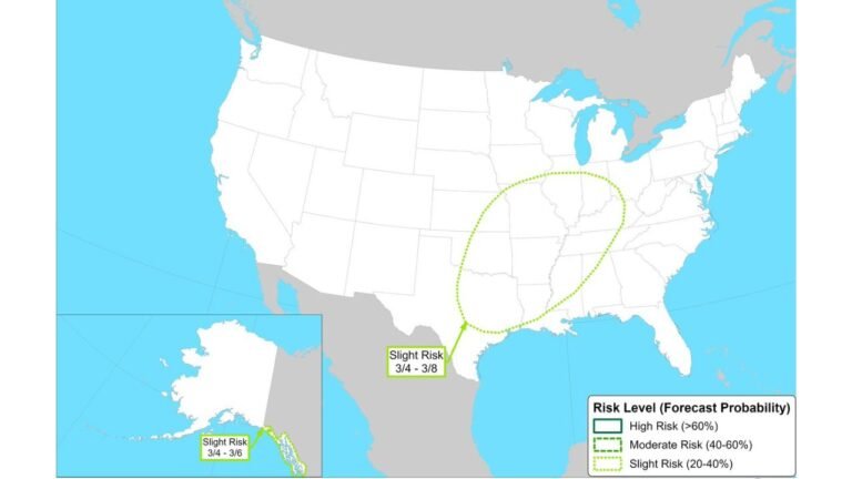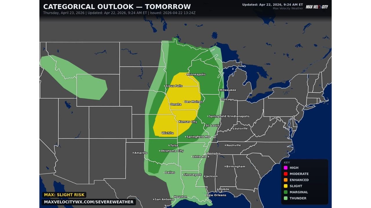
Slight Risk of Damaging Winds Large Hail and Tornadoes Targets Wichita Omaha Kansas City and Minneapolis Thursday
CENTRAL UNITED STATES — A Slight Risk — Level 2 of 5 severe weather outbreak is locked in for Thursday April 23, 2026 across the central United States, with damaging winds, large hail, and a few tornadoes all possible as storms fire and intensify through the afternoon and evening hours across a corridor stretching from Wichita and Kansas City northward through Omaha, Des Moines, Sioux Falls, and Minneapolis.
Slight Risk Core Covers Wichita to Minneapolis
The yellow Slight Risk zone covers a well-defined north-to-south corridor anchored by some of the most populated cities in the central Plains and upper Midwest. Wichita, Kansas City, Omaha, Des Moines, Sioux Falls, and Minneapolis all sit directly within Thursday’s Slight Risk footprint, placing millions of residents under the threat of organized severe thunderstorm activity through the afternoon and evening.
A broader Marginal Risk — Level 1 zone surrounds the Slight Risk core, extending the general severe weather threat across a much wider area covering Oklahoma City, Tulsa, Dallas, Springfield Missouri, St. Louis, Chicago, Milwaukee, and Little Rock.
All Three Major Hazards on the Table Thursday
Thursday’s severe weather profile is well-rounded and serious. Damaging straight-line winds are the most widespread threat as squall line segments develop along the advancing frontal boundary. Large hail is possible particularly with any discrete supercell activity that manages to develop ahead of the main line during peak heating hours. A few tornadoes cannot be ruled out, especially during the late afternoon and early evening hours when atmospheric instability reaches its peak.
| Risk Zone | Cities | Hazards |
|---|---|---|
| Slight — Level 2 | Wichita, KC, Omaha, Des Moines, Minneapolis | Winds, hail, tornadoes |
| Marginal — Level 1 | OKC, Tulsa, Dallas, St. Louis, Chicago | Isolated severe possible |
| Thunder only | Outer fringe | General storm activity |
Storms Develop Through Afternoon and Evening
The severe weather window on Thursday is expected to span the afternoon through evening hours as the storm system matures and pushes eastward. Early afternoon may remain relatively quiet before storm initiation accelerates during peak daytime heating. Residents in the Slight Risk zone should be sheltered and weather-aware by early afternoon and remain vigilant through the overnight hours as the line progresses.
Stay with CabarrusWeekly.com for live severe weather updates across the central Plains and upper Midwest through Thursday evening.