5 Percent Tornado Probability and 2 Inches of Rain Threaten Kansas City Late Thursday Afternoon and Evening
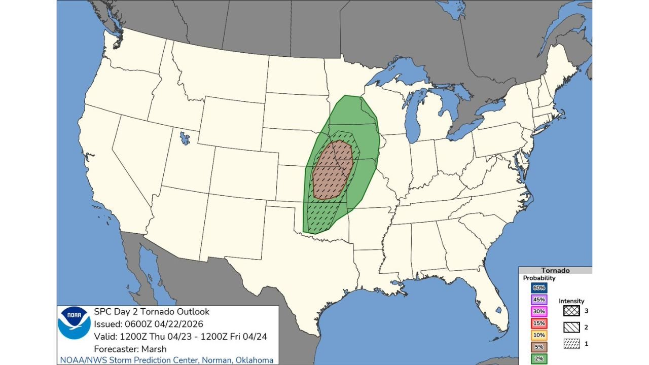
KANSAS CITY, MISSOURI — The Storm Prediction Center’s Day 2 Tornado Outlook valid Thursday April 23 through Friday April 24 places Kansas City directly within a 5 percent tornado probability zone — with the severe thunderstorm threat timed for late Thursday afternoon and evening and up to 2 inches of rain possible with the heaviest storms.
5 Percent Tornado Zone Covers Kansas City Into Oklahoma
The SPC Day 2 tornado outlook issued April 22 shows a well-defined 5 percent tornado probability zone — marked by the brown hatched shading — centered across a corridor covering Kansas City southward through eastern Kansas and into Oklahoma. A broader marginal surrounding zone extends the general tornado-capable environment northward into Iowa and southward toward the Arkansas border.
The hatching within the 5 percent zone indicates Intensity Level 2 tornado potential — meaning organized tornado development is possible with the right storm mode during Thursday evening’s most active period.
Severe Threat Timed for Late Afternoon and Evening KC Area
The severe weather window for the Kansas City area is specifically timed for late Thursday afternoon and into Thursday evening, giving residents a clear heads-up that the threat is not an all-day event but rather concentrated during the after-work and dinner hours when storm coverage will be highest.
Residents across the Kansas City metro should have severe weather plans in place before Thursday afternoon and avoid complacency during the morning and early afternoon hours when skies may appear relatively quiet.
Up to 2 Inches of Rain Possible With Thursday Storms
Beyond the tornado and severe wind threat, the thunderstorm complex moving through Thursday evening carries the potential to drop up to 2 inches of rainfall across portions of the Kansas City area. This heavy rainfall potential could lead to localized flooding of low-lying roads and drainage areas in addition to the wind and tornado hazards associated with the severe storms.
| Hazard | Details |
|---|---|
| Tornado Probability | 5% within 25 miles |
| Tornado Intensity Zone | Level 2 |
| Timing | Late Thursday afternoon and evening |
| Rainfall Potential | Up to 2 inches |
| Today’s Conditions | Sunny, high near 78°F |
Sunny and 78 Degrees Today Before Thursday’s Threat
Tuesday brings a stark contrast to Thursday’s incoming severe weather, with sunny skies and a high near 78 degrees expected across the Kansas City area today. The pleasant Tuesday afternoon gives residents time to prepare and review severe weather plans before conditions deteriorate Thursday evening.
Stay with CabarrusWeekly.com for live tornado and severe thunderstorm updates across the Kansas City area through Thursday evening.