Illinois Faces Its Highest Severe Weather Threat of the Season on Monday April 27 With EF3 Tornadoes and 60 Percent Probability of Severe Storms
ILLINOIS — Monday, April 27, 2026 is shaping up as the highest ceiling severe weather event of the 2026 season so far for Illinois, with a Moderate Risk (Level 4 of 5) in place across a large portion of the state, a 60 percent or greater probability of severe weather across the core zone, and the potential for long-tracked, intense EF3-or-stronger tornadoes from Monday afternoon into Monday night.
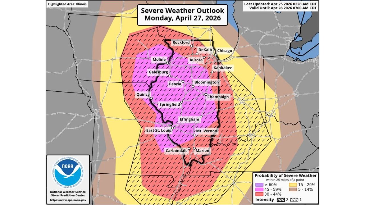
The Highest Threat of the Season for Illinois
Forecasters are explicitly calling this the highest confidence significant severe weather setup of the season for Illinois, including northern Illinois. The full suite of hazards is on the table — damaging wind gusts, very large hail, and long-tracked intense tornadoes — across a broad area of the state.
The outlook will likely be upgraded further as Monday approaches, given how strongly the atmospheric pattern is evolving. Any plans for Monday afternoon and evening should account for this threat.
Where the Greatest Risk Is Focused
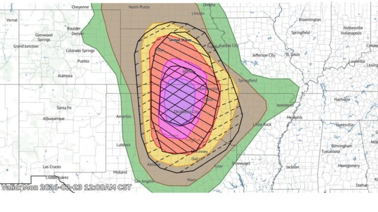
The Moderate Risk (Level 4) covers a wide swath of central and northern Illinois, with the highest tornado confidence in the pink outlined area on the probability map. This corridor runs from Rockford and DeKalb in the north through Peoria, Springfield, Effingham, and down to Carbondale and Marion in southern Illinois.
The core zone — where 60 percent or greater severe weather probability is indicated — encompasses Moline, Galesburg, Quincy, Peoria, Bloomington, Springfield, Champaign, Effingham, East St. Louis, Mt. Vernon, Carbondale, and Marion.
Risk Level Breakdown
| Risk Level | Zone | Key Cities |
|---|---|---|
| Moderate Risk — Level 4 | Highest risk — pink outlined area | Peoria, Springfield, Bloomington, Effingham, Carbondale |
| Enhanced Risk — Level 3 | Surrounding area | Rockford, Aurora, Kankakee, Quincy, East St. Louis |
| Slight Risk — Level 2 | Outer zone | Chicago, Moline, broader Illinois border regions |
Severe Weather Probability
| Probability | Coverage |
|---|---|
| 60% or greater | Core of central Illinois — Peoria to Carbondale corridor |
| 45 to 59% | Broad central Illinois zone |
| 30 to 44% | Northern and southern Illinois fringe |
| 15 to 29% | Chicago, Indiana border, outer zones |
A Critical Overnight Threat Into Indiana
The severe weather threat does not end at sunset. After dark Monday night, storms are expected to transition into a QLCS tornado threat — a dangerous type of storm system capable of producing brief but violent tornadoes with little warning time — as the system pushes east from Illinois into Indiana overnight.
Residents in northern and central Indiana should also be monitoring this event closely for the overnight hours.
Uncertainty Still Exists for Chicagoland
Forecasters note less confidence for far northern Illinois and the Chicago metro area, as morning and afternoon convection ahead of the main event could hold back moisture and instability in that zone. However, this does not eliminate the threat for Chicagoland — it simply means the situation will need close monitoring through the weekend.
What to Do Before Monday
- All Monday afternoon and evening outdoor plans should be reconsidered across Illinois
- Identify the lowest floor of the sturdiest building available to you now — not Monday
- Ensure you have multiple ways to receive tornado warnings, including overnight alerts
- Mobile homes offer no protection — arrange alternative shelter before the event
- This outlook is expected to be upgraded — check back for updates through the weekend
Stay with CabarrusWeekly.com for continuing and frequent updates on Monday’s major severe weather threat across Illinois and Indiana.