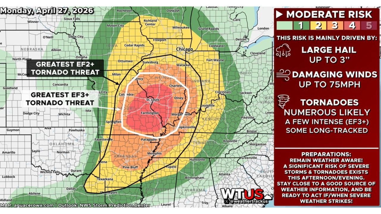
Missouri and Illinois Under Level 4 Moderate Risk With Numerous EF3 Tornadoes, 3-Inch Hail and 75 MPH Winds Possible Today Until 11 PM
MISSOURI AND ILLINOIS — A Level 4 of 5 Moderate Risk of severe storms is in effect today, Monday, April 27, 2026 across parts of Missouri and Illinois, with numerous tornadoes — some intense and long-tracked at EF2 to EF3-plus intensity, large to destructive hail up to 3 inches in diameter, and damaging winds up to 75 mph all expected between 9:00 AM and 11:00 PM CDT.
Greatest EF3-Plus Tornado Threat Is Now
The outlook map identifies two distinct tornado intensity zones centered on the Missouri-Illinois border region:
Greatest EF3-plus tornado threat — the white circled innermost zone centered on St. Louis, Farmington, Columbia, and Olney — this is the most dangerous area today where the most intense and potentially long-tracked tornadoes are most likely.
Greatest EF2-plus tornado threat — the surrounding black outlined zone extending through Quincy, Charleston, Paducah, Hopkinsville, Jonesboro, and Paragould — a broad area where significant tornadoes remain likely.
Full Hazard Breakdown
| Hazard | Threat Level |
|---|---|
| Large to destructive hail | Up to 3 inches in diameter |
| Damaging winds | Up to 75 mph |
| Tornadoes | Numerous likely — a few intense EF3-plus, some long-tracked |
Risk Zone Breakdown
| Risk Level | Key Cities |
|---|---|
| Moderate Risk — Level 4 (highest today) | St. Louis, Farmington, Columbia MO, Olney IL, Paducah |
| Enhanced Risk — Level 3 | Quincy, Springfield IL, Charleston, Hopkinsville, Jonesboro |
| Slight Risk — Level 2 | Chicago, Cedar Rapids, Memphis, Huntsville, Cincinnati |
| Marginal Risk — Level 1 | Omaha, Milwaukee, Nashville, Birmingham, Atlanta |
Timeline for Today
Severe storm activity is expected across Missouri and Illinois from 9:00 AM through 11:00 PM CDT — a nearly 14-hour window of continuous severe weather threat. The most dangerous supercell and tornado-producing activity is expected during the afternoon and evening hours as the atmosphere fully destabilizes and forcing mechanisms intensify.
Act Right Now
If you are located across St. Louis, Farmington, Columbia, Olney, Paducah, or anywhere within the Moderate or Enhanced Risk zones:
- Get to your shelter location before storms arrive
- Stay close to a reliable source of weather warnings through 11:00 PM tonight
- Mobile homes offer no protection — be inside a permanent structure now
- Be ready to act immediately when severe weather strikes — do not wait
Stay with CabarrusWeekly.com for continuous live updates through tonight’s severe weather event across Missouri and Illinois.