Missouri, Illinois, Indiana and Tennessee Face 60 Percent Tornado Probability and 165 MPH Wind Threat Today While Arkansas and Texas Reset Tomorrow
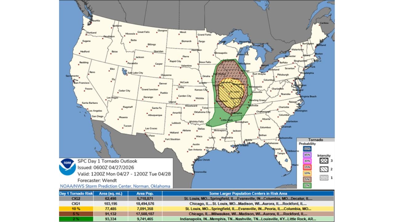
MID-MISSISSIPPI AND OHIO VALLEYS — A busy and dangerous day and night is unfolding across the Mid-Mississippi and Ohio Valleys on Monday, April 27, 2026, with the SPC Day 1 Tornado Outlook placing a 60 percent tornado probability with Intensity 3 significant tornado hatching across a corridor covering Missouri, Illinois, Indiana, and into Tennessee — with tornadoes producing winds up to 165 mph possible. Meanwhile, the atmosphere resets tomorrow for the ArkLaTex region, bringing a second round of tornado potential to Arkansas, Louisiana, and Texas.
60 Percent Tornado Probability — A Rare and Extreme Signal
The SPC Day 1 Tornado Outlook issued at 0600Z April 27 places the maximum tornado probability at 60 percent — one of the highest single-day tornado probability values the SPC issues — with Intensity 3 significant tornado hatching covering the core risk zone. This level of probability reflects near-certainty of a significant tornado outbreak within the hatched area.
Population Exposure Is Staggering
| Risk Zone | Area sq. miles | Population Exposed | Major Cities |
|---|---|---|---|
| CIG2 — 60% hatched | 62,498 | 5,718,871 | St. Louis MO, Springfield IL, Evansville IN, Columbia MO, Decatur IL |
| 10% zone | 77,485 | 7,091,358 | St. Louis, Springfield IL, Evansville, Peoria, Columbia MO |
| 5% zone | 91,132 | 17,508,187 | Chicago IL, Milwaukee WI, Madison WI, Aurora IL, Rockford IL |
| 2% zone | 93,334 | 9,741,465 | Indianapolis IN, Memphis TN, Nashville TN, Louisville KY, Little Rock AR |
Nearly 5.7 million people are located within the highest 60 percent tornado probability zone alone. The total population within the broader risk area extends to tens of millions across the Midwest and Mid-South.
Tonight and Overnight — Tornado Threat Continues After Dark
Forecasters are explicitly warning residents to ensure they can receive tornado warnings after dark. The overnight tornado threat is a critical concern — nighttime tornadoes are significantly more deadly because people are asleep and warning lead times are effectively reduced without active monitoring.
Keep a weather radio or alert-enabled phone active overnight — this is not optional in tonight’s environment.
Tomorrow — ArkLaTex Resets for Another Round
The atmosphere will reset overnight for Arkansas, Louisiana, and Texas, with the Day 2 tornado outlook for Tuesday showing a 30 percent tornado probability with Intensity 3 hatching centered on the Dallas, Wichita Falls, and Shreveport corridor extending into Arkansas, Louisiana, and Mississippi. A surrounding 10 to 15 percent zone covers a broader area of the region.
This means that while today’s primary outbreak targets the Midwest, the ArkLaTex and surrounding states face their own significant tornado threat tomorrow, Tuesday April 28.
Hazard Summary
| Threat | Details |
|---|---|
| Tornadoes | 60% probability today — violent EF3-plus with winds up to 165 mph possible |
| Timing today | Day into night — overnight threat continues |
| Tomorrow ArkLaTex | 30% tornado probability — Dallas, Shreveport, Little Rock corridor |
| Night awareness | Must be able to receive warnings after dark |
Act Now — Before Storms Arrive
Residents across St. Louis, Springfield Illinois, Evansville, Columbia Missouri, Decatur, and the surrounding region within the 60 percent zone must be sheltered before storms arrive this afternoon. Do not wait for warnings before moving to your shelter location.
Residents across Arkansas, Louisiana, and Texas should begin monitoring tomorrow’s setup tonight, as the atmosphere resets for a second outbreak day on Tuesday.
Stay with CabarrusWeekly.com for continuous live coverage through today’s outbreak and into tomorrow’s ArkLaTex severe weather threat.