Arkansas Faces Scattered Supercells, Very Large Hail and Isolated Tornadoes From 5 PM Through 2 AM Tuesday
ARKANSAS — A significant severe weather threat is developing across Arkansas this Monday evening, April 27, 2026, with scattered supercells expected to form between 5:00 PM and 8:00 PM and the threat continuing through 2:00 AM Tuesday. Any supercell that develops will be capable of producing very large hail between 2 and 4 inches in diameter and isolated tornadoes, with the highest tornado threat focused on northeast Arkansas.
Timing and Storm Development
Supercells may begin forming as early as 3:00 PM across east and northeast Arkansas, though the primary and more likely development window is 6:00 PM to 9:00 PM. Storms will generally move east and will eventually cluster into lines as the night progresses. The severe weather threat is expected to wind down sometime between 2:00 AM and 4:00 AM across east and southeast Arkansas.
Primary Threats This Evening
- Very large hail — 2 to 4 inches in diameter with any organized supercell
- Isolated tornadoes — highest threat across northeast Arkansas
- Scattered supercells forming into lines — damaging winds possible as storms consolidate overnight
Threat Zone and Futurecast
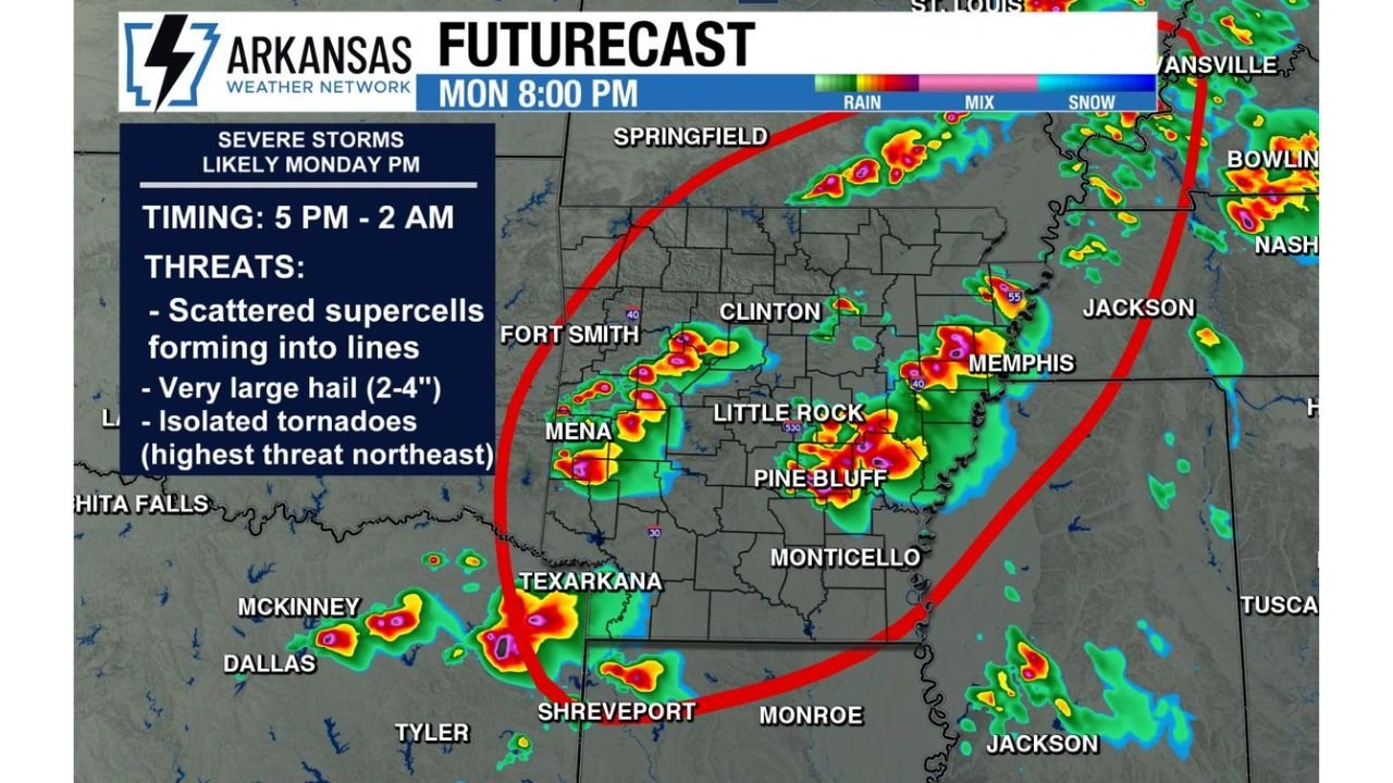
The Arkansas futurecast valid at 8:00 PM Monday shows the most intense storm activity concentrated across a corridor from Fort Smith and Mena through Little Rock, Pine Bluff, and Memphis, with additional activity pushing through northeast Arkansas toward Jackson, Tennessee. The red circled zone encompasses the primary severe weather corridor for the evening.
| Timing | Storm Activity |
|---|---|
| 3:00 PM | Possible early supercell attempts in east and northeast Arkansas |
| 5:00 PM to 8:00 PM | Primary supercell development window |
| 6:00 PM to 9:00 PM | Most likely period for organized storm activity |
| Overnight into 2:00 to 4:00 AM | Storms cluster into lines, threat ends across east and southeast Arkansas |
Coverage Will Be Scattered — Not Everyone Gets Rain
Forecasters are clear that coverage will be scattered — some locations across Arkansas will see no rain at all tonight. However, the storms that do develop will be capable of significant hazards, and the scattered nature of activity makes it difficult to predict exactly which communities will be impacted.
Every Arkansas resident in the risk zone should have a severe weather safety plan ready before 5:00 PM regardless of whether storms appear imminent in their immediate area.
Northeast Arkansas Is the Highest Tornado Risk
The isolated tornado threat is highest across northeast Arkansas — residents near Jonesboro, Paragould, Blytheville, and surrounding areas face the greatest tornado probability of any part of the state this evening and should be especially vigilant through the overnight hours.
Stay with CabarrusWeekly.com for continuing coverage of tonight’s severe weather threat across Arkansas.