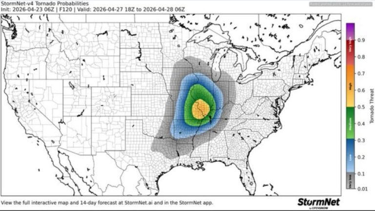
Illinois, Missouri, Arkansas and Indiana Face Severe Weather Outbreak Today With Several Strong Tornadoes, Very Large Hail and Damaging Winds Likely
MIDWEST AND MISSISSIPPI VALLEY — A severe weather outbreak is expected today, Monday, April 27, 2026, across the Midwest and Mississippi Valley, with very large hail, damaging winds, and several strong tornadoes all likely across a corridor centered on Illinois, Missouri, Arkansas, and Indiana. It is vital to stay weather aware today and share this threat with friends and family.
Enhanced Risk at the Core
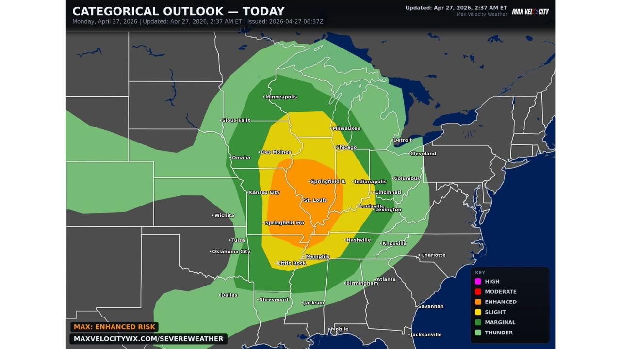
The categorical outlook updated at 2:37 AM ET places an Enhanced Risk (Level 3 of 5) across the highest-risk corridor stretching from Springfield Missouri and Kansas City through St. Louis, Springfield Illinois, and into Indianapolis. This is a broad and densely populated risk zone where the greatest concentration of severe storm activity is expected today.
Risk Zone Breakdown
| Risk Level | Key Cities |
|---|---|
| Enhanced Risk — Level 3 | St. Louis, Springfield IL, Springfield MO, Kansas City, Indianapolis |
| Slight Risk — Level 2 | Chicago, Milwaukee, Des Moines, Memphis, Little Rock, Louisville, Cincinnati |
| Marginal Risk — Level 1 | Minneapolis, Sioux Falls, Omaha, Nashville, Knoxville, Birmingham |
Primary Hazards Today
- Several strong tornadoes — likely across the Enhanced Risk corridor
- Very large hail — significant and widespread threat
- Damaging straight-line winds — expected with any organized storm line
Stay Weather Aware All Day
The threat is not confined to a single brief window — this is an all-day and into the evening severe weather event across the Midwest and Mississippi Valley. Residents across the Enhanced and Slight Risk zones must keep multiple warning sources active throughout the entire day and be ready to act the moment warnings are issued for their location.
Do not wait. Spread the word. Stay with CabarrusWeekly.com for continuous live coverage of today’s severe weather outbreak.