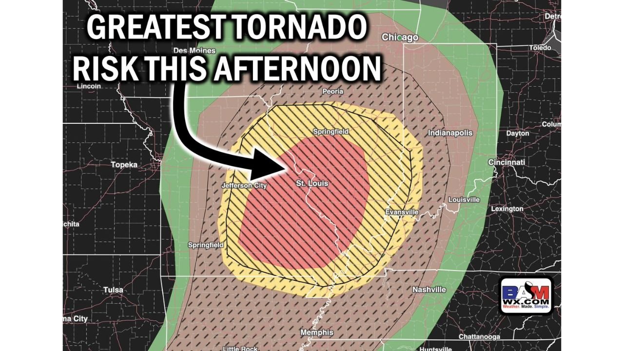
St. Louis, Springfield and Evansville Face the Greatest Tornado Risk This Afternoon With Strong to Intense Tornadoes and 3-Inch Hail Possible
MISSOURI AND ILLINOIS — The greatest tornado risk this afternoon is centered directly on St. Louis, Jefferson City, Springfield Illinois, and Evansville, with an elevated and concentrated tornado threat in place for the afternoon and evening hours on Monday, April 27, 2026. Some tornadoes may be strong to intense, and large to very large hail of 2 to 3 inches or larger is also possible across the core risk zone.
The Bullseye Is St. Louis and Surrounding Region
The tornado probability map shows a tightly concentrated risk zone with the absolute highest tornado probability centered on St. Louis and the surrounding Missouri-Illinois border corridor. The risk zones expand outward from that core in concentric rings:
| Probability Zone | Areas Included |
|---|---|
| Highest — red hatched core | St. Louis, Jefferson City, southern Illinois border |
| Very high — yellow hatched zone | Springfield IL, Evansville, Louisville, Jefferson City, Springfield MO |
| Elevated — brown hatched zone | Peoria, Indianapolis, Nashville, Memphis, Topeka |
| Marginal outer zone | Chicago, Des Moines, Cincinnati, Chattanooga |
Strong to Intense Tornadoes Possible
This is not a setup where only brief, weak tornadoes are expected. The atmospheric environment supports strong to intense tornado development — meaning EF2-plus and potentially EF3-plus tornadoes are possible within the core red and yellow hatched zones. Anyone within the highest-risk area must treat this threat with the utmost seriousness.
Hail Threat Accompanies the Tornado Risk
In addition to tornadoes, large to very large hail of 2 to 3 inches or larger is possible with any organized supercell across the risk zone. Vehicles left outside in the path of these storms face significant damage risk.
Immediate Action Required for the Core Zone
If you are in St. Louis, Jefferson City, Springfield Illinois, Evansville, or anywhere within the red or yellow hatched zones:
- Get to your shelter on the lowest floor of a sturdy building now
- Do not wait for a tornado warning — by the time one is issued, the storm may already be close
- Keep multiple warning sources active through the entire afternoon and evening
- Mobile homes offer no protection — be in a permanent structure before storms arrive
Stay with CabarrusWeekly.com for continuous live coverage as today’s tornado threat unfolds across Missouri and Illinois.