Alabama Faces Slight Risk of Severe Storms Tuesday April 28 With Damaging Winds the Primary Threat From 5 PM Through Midnight
ALABAMA — A Slight Risk (Level 2 of 5) of severe thunderstorms is in effect for much of Alabama north of a line from Uriah to Troy to Auburn on Tuesday, April 28, 2026, with a fast-moving band of storms pushing into West Alabama around 5:00 to 6:00 PM and tracking east through the state overnight. Damaging straight-line winds are the primary concern, with an isolated tornado possible across the western third of the state.
Fast-Moving Storm Band Arrives Late Afternoon
A fast-moving line of storms will push into West Alabama around 5:00 to 6:00 PM this afternoon. The storms are expected to move quickly eastward through the state, with activity weakening after midnight as the line tracks into East and South Alabama.
The primary and dominant threat with this system is strong, potentially damaging straight-line winds embedded within the fast-moving band. This is not a slow-moving, tornado-focused event — the speed of storm movement and the linear nature of the system make winds the lead hazard.
Isolated Tornado Cannot Be Ruled Out
While winds are the main concern, a brief isolated tornado or two cannot be ruled out — particularly across the western third of Alabama where the most organized storm activity will be as the line first pushes into the state. The tornado outlook shows a 5 to 9 percent tornado probability across portions of north and central Alabama west of Birmingham.
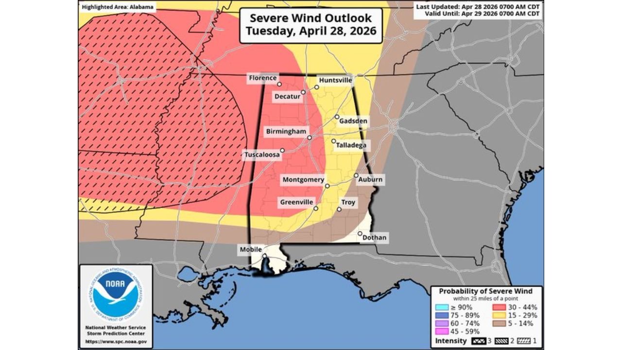
Severe Wind Probability Breakdown
The severe wind outlook shows the most significant wind threat concentrated across central and northern Alabama:
| Wind Probability | Areas |
|---|---|
| 45 to 59% — pink zone | Tuscaloosa, Birmingham, Decatur, Gadsden, Montgomery corridor |
| 30 to 44% — yellow zone | Broader central Alabama including Talladega, Greenville, Troy, Auburn |
| 15 to 29% — tan zone | Outer fringe including Florence, Huntsville, southern Alabama |
Intensity 3 hatching is present across the highest wind probability zone — confirming that significant damaging wind gusts are explicitly anticipated across central Alabama.
Risk Zone and Tornado Outlook
| Risk Level | Areas Covered |
|---|---|
| Slight Risk — Level 2 | North of Uriah to Troy to Auburn — Birmingham, Tuscaloosa, Huntsville, Montgomery, Gadsden, Decatur, Florence |
| Marginal Risk — Level 1 | Portions of south Alabama and surrounding fringe areas |
The tornado outlook shows a 5 to 9 percent tornado probability across northwest Alabama west of Birmingham, with a 2 to 4 percent probability extending through central Alabama. The tornado threat is secondary to winds but real — especially in the western counties as storms first arrive.
Timeline for Tuesday
| Time | Activity |
|---|---|
| 5:00 PM to 6:00 PM | Storm band enters West Alabama |
| Evening hours | Line tracks eastward through central Alabama |
| After midnight | Storms weaken as they push into East and South Alabama |
Prepare Before 5 PM
Residents across Birmingham, Tuscaloosa, Montgomery, Decatur, Gadsden, and surrounding areas should be weather aware before 5:00 PM and have shelter plans ready. Keep multiple warning sources active through the overnight hours as the line continues east.
Stay with CabarrusWeekly.com for continuing updates on Tuesday’s severe weather threat across Alabama.