Deep South, Gulf States and Mid-Atlantic Face Severe Storm Threat Today With Storm Cluster Likely From Texas Through the Gulf Coast
UNITED STATES — Severe weather is expected across a wide area of the country on Wednesday, April 29, 2026, with the primary threat concentrated across the Deep South and Gulf states and a more isolated severe risk developing across the Upper Southeast and Mid-Atlantic later in the day.
Where the Greatest Severe Weather Risk Is Focused Today
A cluster of severe storms is likely to develop across Texas and push into the Gulf states throughout the day. The Day 1 Severe outlook from the National Weather Service Storm Prediction Center shows a Slight Risk zone stretching in a broad band across the southern tier from Texas through the Gulf Coast states and into Florida.
A separate and broader Marginal Risk zone extends northward and eastward, covering much of the Upper Southeast, Appalachians, and Mid-Atlantic corridor.
The Mid-Atlantic Threat Is Isolated, Not Widespread
Across the Mid-Atlantic, the atmosphere will attempt to become unstable enough to support isolated strong to severe storms. However, this threat is not expected to be widespread across this region. Scattered activity is possible but large organized severe weather is not anticipated for the Upper Southeast and Mid-Atlantic zone.
How the Storm System Is Moving Through the Day
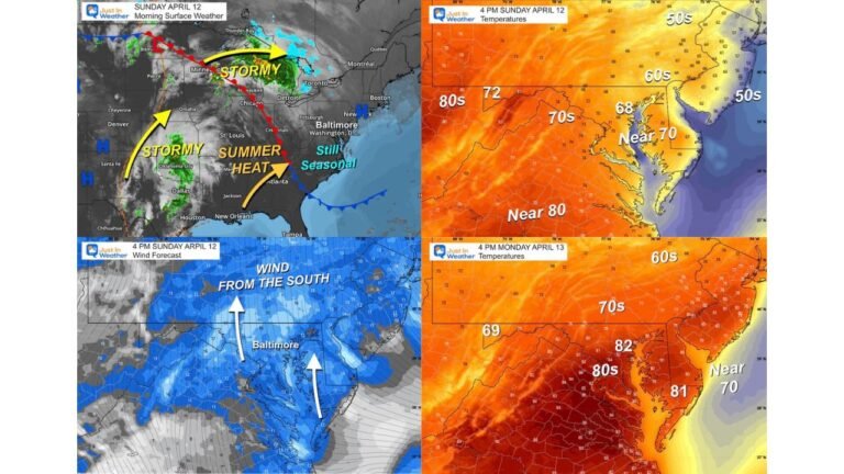
HRRR radar data valid 8:00 PM CDT Wednesday, April 29, 2026 shows storm activity already developing across East Texas and into the Gulf Coast, with intense cells pushing through the region. By 1:00 AM and 2:00 AM Thursday, April 30, 2026, the storm cluster pushes eastward into Mississippi, Alabama, and Georgia, with a broad and intense area of rainfall and thunderstorm activity spreading across the central Gulf states.
Simultaneously, a separate area of active storms is shown pushing through Virginia, Maryland, Pennsylvania, and the Mid-Atlantic by early Thursday morning, consistent with the isolated severe threat for that region.
Hazards to Watch Across Both Zones
Deep South and Gulf States:
- Cluster of severe storms likely
- Damaging winds
- Large hail
- Tornado threat within the cluster
- Heavy rainfall
Upper Southeast and Mid-Atlantic:
- Isolated strong to severe storms possible
- Gusty winds
- Heavy downpours
- Lightning
The Timeline for Today and Tonight
Storm activity is already developing across East Texas and the Gulf Coast during the afternoon hours of Wednesday. The cluster pushes eastward through the evening and overnight, spreading across Mississippi, Alabama, and Georgia by early Thursday morning. The Mid-Atlantic activity intensifies during the late evening and overnight hours, with storms pushing through Virginia and Maryland toward 1:00 AM Thursday.
Conditions are expected to gradually improve behind the system as it pushes offshore Thursday.
Stay with CabarrusWeekly.com for continuing updates as this severe weather outbreak moves through the Deep South, Gulf states, and Mid-Atlantic today and tonight.