Carolinas and Georgia Face Cloudy, Cool and Damp Saturday With Heavy Rain Near the Coast and a Sharp Gradient Inland
NORTH CAROLINA — Saturday is shaping up to be a cloudy, cool, and damp day across the Carolinas and Georgia, with a very tight rainfall gradient from the coast inland. A low-pressure system tracking near the coast combined with cold air damming will keep temperatures locked in the 50s all day, with drizzle, mist, and light rain expected to dominate for most areas — while coastal communities see significantly higher rainfall totals.
The Rainfall Gradient From Coast to Interior
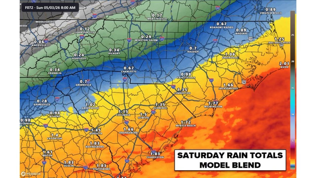
Model blend data valid Sunday, May 3, 2026 at 8:00 AM — capturing Saturday’s accumulated totals — shows a dramatic difference in rainfall depending on how close an area sits to the coast. The heaviest totals are concentrated along and near the North Carolina and South Carolina coast, with amounts dropping off sharply moving inland and westward.
Key rainfall totals from the model blend include:
Coastal and Near-Coastal NC/SC:
- Avon: 2.01″
- Kill Devil Hills: 1.25″
- Wilmington: 1.77″
- Myrtle Beach: 1.72″
- Jacksonville, NC: 1.66″
- Charleston: 1.83″
- Greenville, NC: 1.06″
Central Carolinas:
- Fayetteville: 0.98″
- Lumberton: 1.35″
- Florence: 1.35″
- Sumter: 1.50″
- Rockingham: 0.93″
- Laurinburg: 1.06″
- Charlotte: 0.67″
- Concord: 0.57″
- Rock Hill: 0.93″
Piedmont and Western NC:
- Raleigh: 0.70″
- Winston-Salem: 0.29″
- Greensboro: 0.42″
- Hickory: 0.34″
- Asheville: 0.24″
- Johnson City: 0.12″
- Knoxville: 0.06″
Upstate SC and Georgia:
- Columbia: 1.15″
- Augusta: 1.45″
- Waynesboro: 1.83″
- Statesboro: 1.83″
- Macon: 1.61″
- Greenwood, SC: 1.02″
Why Saturday Will Feel Wetter Than It Actually Is
Even in areas where rainfall totals are modest, Saturday will feel much wetter than the numbers suggest. A combination of cold air damming, low cloud cover, drizzle, and mist will make for a persistently grey and damp day with temperatures stuck in the 50s from morning through evening. There will be no clearing and no significant dry breaks across most of the region.
The tightest rainfall gradient sits between the Charlotte metro and the coastal plain, where totals nearly double within a relatively short distance eastward.
The Setup Driving Saturday’s Weather
A low-pressure system tracking near the coast is the primary driver of Saturday’s wet and cool conditions. Cold air damming is reinforcing the cool temperatures across the Piedmont and western Carolinas, keeping the moisture onshore and the clouds locked in. The coastal areas directly in the path of the low will see the heaviest and most sustained rainfall throughout the day.
Stay with CabarrusWeekly.com for continuing updates on Saturday’s rain and cool conditions across the Carolinas and Georgia.