Denver and Colorado Face Biggest Snowstorm of the Season Tuesday Night Into Wednesday With 2 to 4 Inches on Roads and 40 to 50 Inches in the Mountains
DENVER, COLORADO — What could be Denver’s biggest snowstorm of the entire winter season is arriving in May, with accumulating snow expected on roads across the metro area Tuesday night into Wednesday, May 6, 2026. The storm will bring 2 to 4 inches on roads and grassy surfaces across the Denver metro while mountain resorts see snowfall totals reaching 40 to 50 inches in the highest elevations.
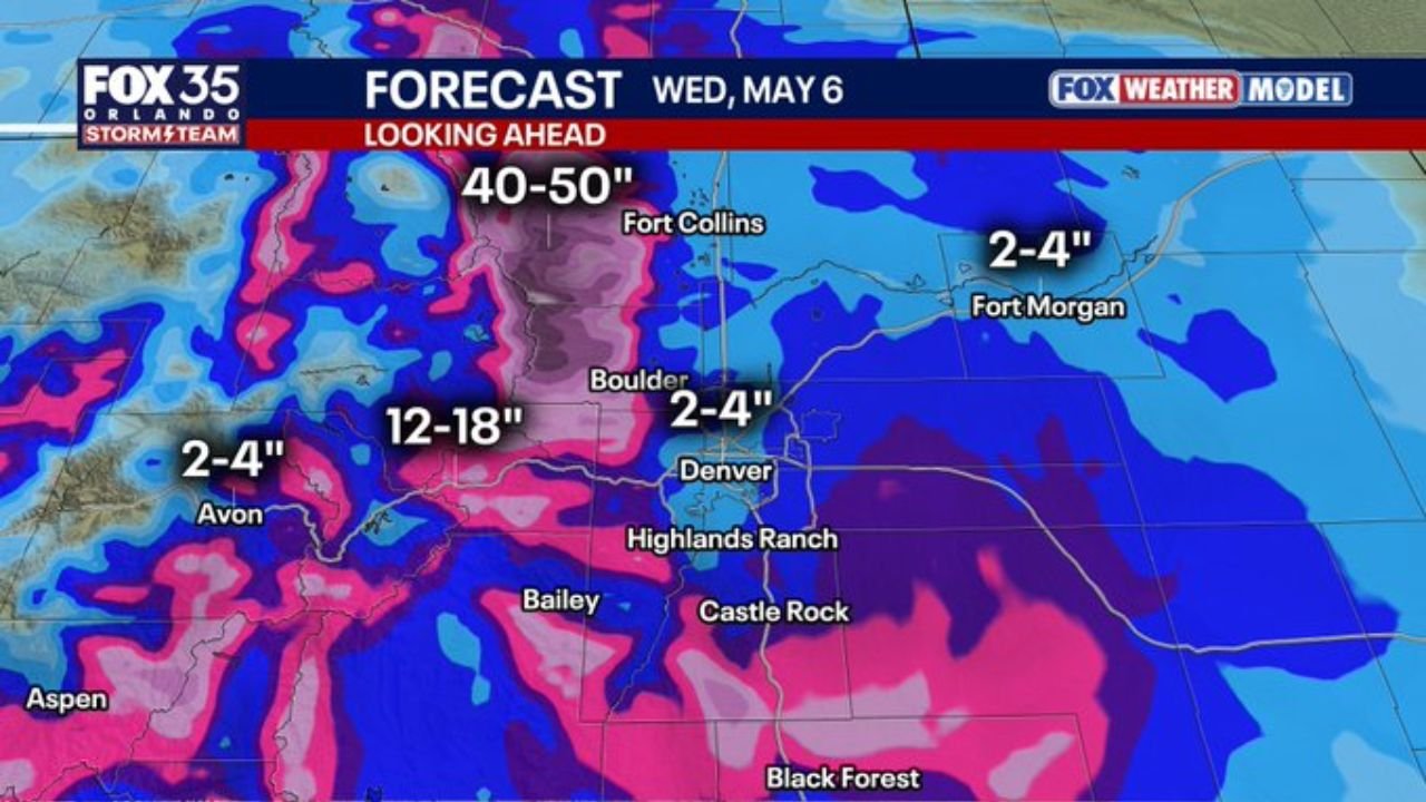
Snowfall Forecast by Location Wednesday May 6
| Location | Expected Snowfall |
|---|---|
| Mountain peaks near Fort Collins | 40 to 50 inches |
| Boulder and foothills corridor | 12 to 18 inches |
| Denver metro | 2 to 4 inches on roads |
| Highlands Ranch and Castle Rock | 2 to 4 inches |
| Avon corridor | 2 to 4 inches |
| Fort Morgan | 2 to 4 inches |
Roads Get 2 to 4 Inches — Higher Totals on Elevated Surfaces
In the Denver metro, the 2 to 4 inch road accumulation is the key number for travel planning. The majority of accumulation will fall on grassy and elevated surfaces around the city, but roads will see enough snow to create slippery and hazardous travel conditions through Wednesday morning. Forecast radar valid at 10:30 AM Wednesday shows snow blanketing the full Denver metro corridor from Fort Collins through Boulder, Denver, Highlands Ranch and Castle Rock.
DIA Flight Delays Expected Wednesday Morning Into Midday
Denver International Airport is expected to see flight delays arriving and departing Wednesday morning into midday as snow impacts operations across the region. Travelers with Wednesday flights through DIA should check their flight status before heading to the airport.
A Historic Late Season Event for Mountain Resorts
For ski resorts across the Colorado mountains, this storm is shaping up to be a several feet range event — a remarkable late-season bonus heading into May. The 40 to 50 inch snowfall zone near Fort Collins and the northern Front Range peaks represents extraordinary accumulations for this time of year.
The combination of leafed out trees and heavy wet snow also raises the risk of downed branches and power outages across the Denver metro and surrounding foothills through Wednesday.
Stay with CabarrusWeekly.com for continuing Denver snowstorm updates through Wednesday May 6.