Cincinnati, Dayton, Columbus, and Indianapolis Face Exiting Showers and Isolated Fog Saturday Morning With Afternoon Severe Storm Potential on the Way
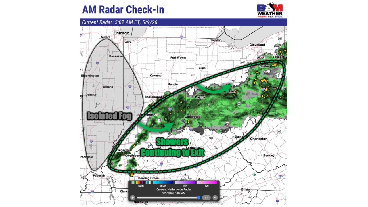
OHIO RIVER VALLEY — Showers are continuing to exit the Ohio River Valley as of 5:02 AM ET on Saturday, May 9, 2026, with the main band of rainfall pushing eastward through Cincinnati, Dayton, Columbus, and the surrounding corridor. A few pockets of isolated fog are lingering across central Illinois near Bloomington, Urbana, and Decatur in the wake of the departing showers. The key question Saturday is how the morning cleanup will impact the afternoon strong to severe storm forecast for the region.
What Radar Shows Saturday Morning at 5:02 AM
The AM radar check-in valid at 5:02 AM ET Saturday May 9 shows the main shower activity concentrated across a corridor stretching from:
- Evansville and Owensboro in the southwest
- Indianapolis and Bloomington, Indiana
- Cincinnati, Dayton, and Columbus, Ohio
- Akron, Canton, Youngstown, and Wheeling along the eastern edge
The shower band is actively pushing eastward and exiting the region, with the western portions of Illinois and Indiana already clearing out. Isolated fog is noted across the central Illinois corridor near Bloomington, Urbana, Kankakee, and Decatur as the rain exits and moisture lingers at the surface.
Why the Morning Matters for the Afternoon Forecast
The pace at which the morning showers clear and how much clearing and surface heating occurs through the late morning and early afternoon hours will directly determine the severity potential for afternoon and evening storms across the Ohio River Valley.
If sufficient clearing and heating occurs ahead of the next weather system, instability could build enough to support strong to severe thunderstorm development during the afternoon hours across Indiana, Ohio, Kentucky, and surrounding areas. Lingering cloud cover and moisture from the morning showers could limit that instability and keep storm intensity in check.
Cities to Watch Through Saturday
Residents across the following communities should monitor conditions closely through the morning and into the afternoon:
- Indianapolis, Indiana
- Cincinnati and Dayton, Ohio
- Columbus, Ohio
- Evansville, Indiana
- Owensboro and Lexington, Kentucky
- Huntington, West Virginia
Stay with CabarrusWeekly.com for continuing updates on Saturday’s Ohio River Valley weather situation through the afternoon severe storm window.