Colorado Faces Active End of May and Early June as Models Signal Fast and Furious Severe Weather Season Start After Calm Next 10 to 14 Days
COLORADO — Multiple long-range models are strongly hinting at an active end to May and early June for Colorado, with severe weather season off to a late start but potentially arriving fast and furious within a few weeks. While the next 10 to 14 days remain relatively calm for the state, the pattern building beyond that window warrants close attention.
What Three Models Are Showing for Late May Into June
All three long-range precipitation anomaly datasets are showing a consistent signal of above-normal precipitation returning to Colorado and the broader central United States during the late May through early June timeframe.
CANSIPS Seasonal valid May through July 2026 shows a broad above-normal precipitation signal across Colorado, Kansas, Nebraska, Oklahoma, and Texas, with the deepest positive anomalies of 8 to 16 inches above normal centered over eastern Colorado and western Kansas. The West Coast and Pacific Northwest remain in a significant below-normal signal.
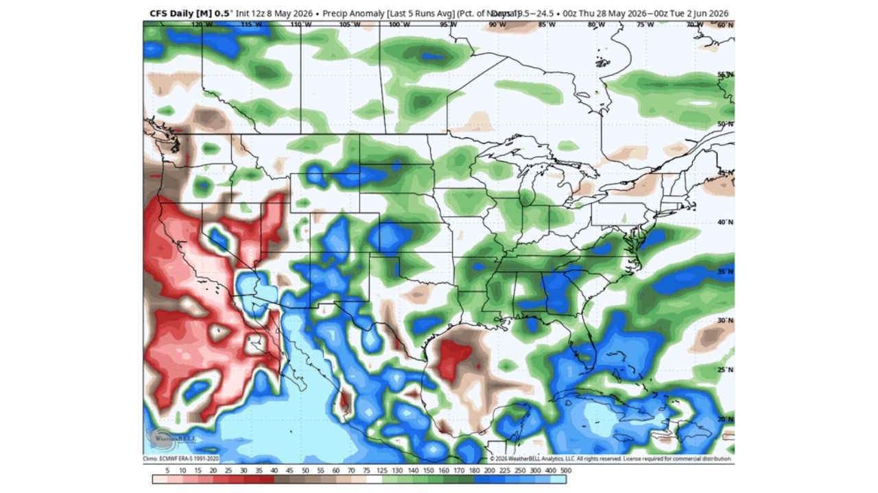
CFS Daily valid May 28 through June 2, 2026 shows the most active signal of the three datasets, with above-normal precipitation percentages of 150 to 300 percent across portions of Colorado, Kansas, Nebraska, and the Central Plains. Notably the CFS also shows a very dry signal across California, Nevada, and the Southwest with below-normal values of 5 to 25 percent during the same period.
ECMWF Seasonal valid May through July 2026 shows a more modest but still notable above-normal precipitation signal across Texas, Oklahoma, and the Gulf Coast, with near-normal to slightly above-normal readings extending northward into Colorado and the Central Plains.
Precipitation Signal Comparison by Model
| Model | Valid Period | Signal for Colorado and Plains | Peak Anomaly |
|---|---|---|---|
| CANSIPS Seasonal | May through July 2026 | Above normal 8 to 16 inches | Over eastern Colorado and western Kansas |
| CFS Daily | May 28 through June 2 | 150 to 300 percent above normal | Central Plains corridor |
| ECMWF Seasonal | May through July 2026 | Slight to moderate above normal | Texas through southern Plains |
The Next 10 to 14 Days Stay Calm for Colorado
Despite the active signal building on the long-range horizon, Colorado will remain relatively calm through the next 10 to 14 days. Severe weather season has been off to a late start across the state, and that quieter pattern is expected to hold through mid-May before the potential pattern shift arrives.
What the Late May Signal Means for Colorado
The consistency across multiple long-range models pointing toward above-normal precipitation and an active pattern for Colorado at the end of May and into early June is a signal worth monitoring closely. If this pattern verifies, it could mean:
- Rapid onset of severe weather season across Colorado and the eastern Plains
- Elevated severe storm potential across Colorado, Kansas, and Nebraska
- Above-normal precipitation returning to drought-stressed areas of the Central Plains
The long-range nature of this forecast carries inherent uncertainty, but the agreement across multiple independent datasets strengthens confidence that a pattern change is on the horizon for Colorado.
Stay with CabarrusWeekly.com for continuing updates on Colorado’s severe weather season outlook and the developing late May pattern shift.