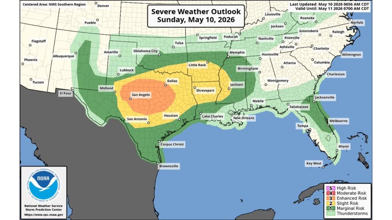
San Angelo, Dallas, Shreveport, Houston, and San Antonio Face Enhanced Risk Severe Storms Sunday May 10 With Very Large Hail, Tornadoes, and 75 MPH Wind Gusts After Dark
TEXAS — An Enhanced Risk Level 3 of 5 of severe storms is in place across a broad corridor of Texas on Sunday, May 10, 2026, with very large hail the primary hazard initially followed by an increasing damaging wind threat after dark as storms undergo upscale growth into an organized system. Wind gusts of 75 MPH or higher will be possible with the overnight storm complex. The outlook is valid until 7:00 AM CDT Monday May 11.
The Risk Zones for Sunday May 10
| Risk Level | Cities Included |
|---|---|
| Enhanced Risk Level 3 of 5 | San Angelo, Midland, and the surrounding west-central Texas corridor |
| Slight Risk Level 2 of 5 | Dallas, Shreveport, Houston, San Antonio, Lake Charles, Little Rock |
| Marginal Risk Level 1 of 5 | Oklahoma City, Lubbock, Amarillo, New Orleans, Mobile, Memphis, Jackson |
How the Threat Evolves Sunday
Afternoon Phase: Very Large Hail and Tornado Threat The initial severe weather window brings discrete supercell activity with very large hail as the primary hazard. A couple of tornadoes are possible, particularly if any cells can latch onto the dry line and outflow boundary intersection during the afternoon hours.
After Dark Phase: Damaging Wind Threat Escalates As upscale growth occurs after dark, storms are expected to consolidate into a larger and more organized system with an increasing damaging wind risk. A few gusts of 75 MPH or higher will be possible across the storm corridor through the overnight hours.
What the HRRR Sounding Confirms
The HRRR sounding valid Monday May 11 at 00Z for the central Texas corridor shows a highly energetic atmospheric profile:
| Parameter | Value |
|---|---|
| MUCAPE | 2195 J/kg |
| MLCAPE | 1763 J/kg |
| Effective Shear | 72 m2/s2 |
| Supercell Composite | 6.2 |
| SHIP | 0.7 |
| Critical Angle | 170 degrees |
| Storm Slinky | 73 degrees |
The MUCAPE of 2195 J/kg combined with effective shear of 72 m2/s2 confirms a highly favorable environment for organized and intense severe thunderstorm development across the region. The supercell composite of 6.2 indicates a strong supercell-supporting environment during the afternoon hours.
Forecast Storm Position at Midnight
The HRRR composite reflectivity valid 00Z Monday May 11 shows an extensive and well-organized band of intense storm activity stretching across a large swath of central and south Texas, with the highest reflectivity values concentrated in a broken but continuous line from west Texas through the Hill Country corridor and into the coastal plain. A secondary area of storm activity is also indicated across portions of Arkansas and the Mid-South.
What Texas Residents Must Do Sunday
Residents across San Angelo, Dallas, Shreveport, Houston, and San Antonio face a two-phase threat requiring preparation both for the afternoon supercell window and the overnight MCS wind threat.
- Secure outdoor furniture and loose objects before afternoon storms develop
- Have a plan to receive warnings both during the afternoon and overnight hours
- Prepare for potential power outages from 75 MPH wind gusts after dark
- Do not assume the threat is over at sunset
Stay with CabarrusWeekly.com for continuing live updates on Sunday’s severe weather outbreak across Texas through Monday morning.