Abilene, Fort Worth, Wichita Falls, and San Angelo Face Baseball Size or Larger Hail Sunday Afternoon as CAPE Values Reach 2000 to 3500 J/kg by 5 PM
ABILENE, TEXAS — Cells are forecast to develop near Abilene, Texas between 3:00 and 5:00 PM on Sunday, May 10, 2026, with an atmosphere loaded with 2000 to 3500 J/kg of surface-based CAPE providing enormous energy for storm intensification. Forecasters warn that baseball-size or larger hail warnings should not be a surprise across the region this afternoon given the extreme instability in place.
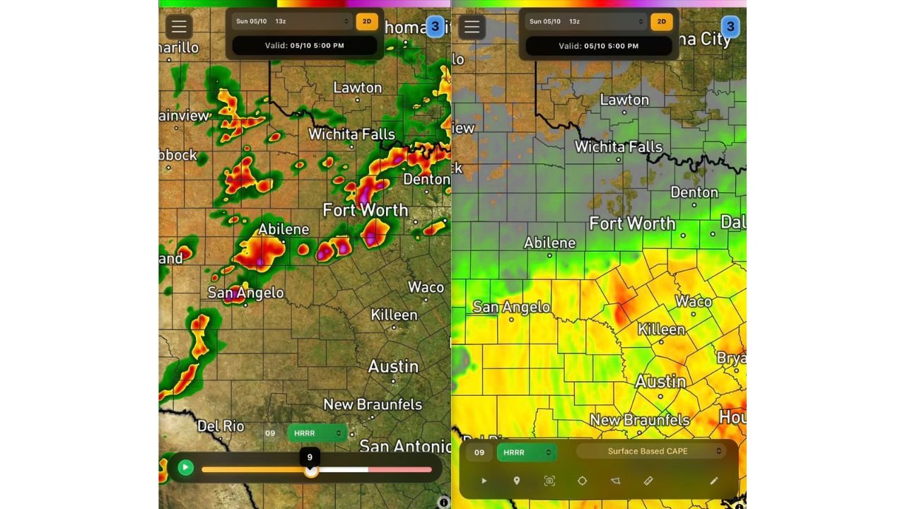
What the CAPE Map Shows at 5:00 PM
The HRRR surface-based CAPE forecast valid 5:00 PM on May 10 shows an extraordinarily energetic atmosphere across central Texas:
| Area | CAPE Values |
|---|---|
| Killeen, Waco, and surrounding corridor | 2000 to 3500 J/kg — red zone |
| Austin and New Braunfels | 1500 to 2500 J/kg — orange to red |
| Abilene and San Angelo | 1000 to 2000 J/kg — yellow to orange |
| Fort Worth and Denton | 500 to 1500 J/kg — green to yellow |
The red zone of 2000 to 3500 J/kg centered near Killeen and Waco represents an exceptionally high-energy environment capable of supporting very intense updrafts and extremely large hail with any supercell that develops in the area.
Future Radar at 5:00 PM Sunday
The HRRR future radar valid 5:00 PM on May 10 shows organized storm activity already underway across the corridor stretching from Abilene and San Angelo northward through Fort Worth, Wichita Falls, and Denton. The most intense radar returns are concentrated near Abilene with additional significant cells indicated near Fort Worth and along the Wichita Falls corridor.
Why Baseball Size Hail Is Possible
With CAPE values of 2000 to 3500 J/kg available to fuel storm updrafts, any discrete supercell developing across central Texas this afternoon will have enormous energy to work with. Strong updrafts supported by this level of instability are capable of lofting hailstones to very large sizes before they fall to the ground.
Forecasters specifically note that baseball-size or larger hail warnings are a real possibility across the Abilene, Fort Worth, Wichita Falls, and San Angelo corridor during the afternoon hours. Anyone with vehicles parked outdoors across these communities should seek covered parking immediately.
What Residents Must Do Right Now
- Move vehicles under covered parking immediately
- Bring outdoor furniture and loose objects inside
- Have multiple ways to receive hail warnings
- Stay indoors once storms develop near your location
- Do not go outside to observe storms
Stay with CabarrusWeekly.com for continuing live updates on Sunday afternoon’s extreme hail threat across Abilene, Fort Worth, Wichita Falls, and San Angelo.