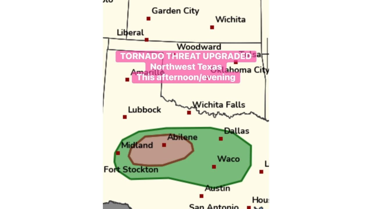
This Afternoon and Evening, Abilene, Midland, Waco, and Dallas Face an Upgraded Tornado Threat as Supercells Erupt From the Permian Basin With Gorilla Hail and Isolated Tornadoes Possible by 3 PM
NORTHWEST TEXAS — The tornado threat has been officially upgraded across Northwest Texas this Sunday afternoon and evening, May 10, 2026, with Abilene directly in the highest-risk zone. Supercell thunderstorms are forecast to erupt out of the Permian Basin into the Texas Hill Country by 3 to 4 PM, bringing the threat of gorilla hail and isolated tornadoes.
Upgraded Threat Zone Covers a Wide Stretch of Texas
The threat map shows two distinct zones across the region:
- Core high-risk zone — centered around Midland and Abilene, representing the area most likely to see the strongest supercells
- Broader threat zone — extends east through Waco and toward Dallas, and south toward Austin and San Antonio
Cities including Fort Stockton, Wichita Falls, and Lubbock sit near or along the edges of the threat area.
Hazards Expected From 3 PM Onward
As supercells fire out of the Permian Basin this afternoon, the following hazards are expected:
- Isolated tornadoes — upgraded and primary threat for Northwest Texas
- Gorilla hail — extremely large hail capable of significant damage
- Damaging winds — associated with any supercell development
Act Now Before Storms Arrive
Storms are expected to develop as early as 3 PM. If you are in or near Abilene, Midland, or anywhere within the threat zone, secure your vehicles, have a shelter plan ready, and monitor conditions closely through the afternoon and evening hours.
Stay with CabarrusWeekly.com for live updates as this upgraded tornado threat unfolds across Northwest Texas this afternoon and evening.