Kansas, Nebraska, Iowa, and Missouri Face a Critical Monday Storm Mode Question as Cold Front Timing Threatens to Unleash Violent Tornadoes or Destructive Wind
UNITED STATES — The biggest uncertainty heading into Monday’s historic severe weather event is not whether dangerous storms will develop, it is how they will develop. The timing of a cold front crashing southward during the afternoon and evening hours on Monday, May 18, 2026 will determine whether millions face a long-duration tornado threat or a destructive damaging wind event across Kansas, Nebraska, Iowa, and Missouri.
Two Very Different Outcomes Hinge on One Factor
Forecasters are watching the cold front’s timing more closely than anything else right now. That single factor will shape the entire character of Monday’s storm outbreak. Two distinct scenarios are on the table, and both are dangerous.
What Happens if the Cold Front Moves Slowly
A slower cold front creates the most dangerous tornado scenario. It gives tornadic supercells more room to operate along the dryline and inside the warm sector before the front arrives. Under this scenario, the tornado threat would last through at least early evening, giving violent storms a long window to track across the landscape. These discrete supercells would be capable of producing large hail and significant tornadoes before conditions eventually shift.
What Happens if the Cold Front Moves Faster
A faster cold front compresses that tornado window but does not eliminate the danger. Storms would shift into a more linear mode earlier, meaning the primary threat transitions toward widespread damaging winds with embedded hail and tornadic circulations. A few tornadoes would still be possible even in this scenario, but the outbreak would be shorter and more wind-driven than tornado-driven.
The Science Behind the Uncertainty
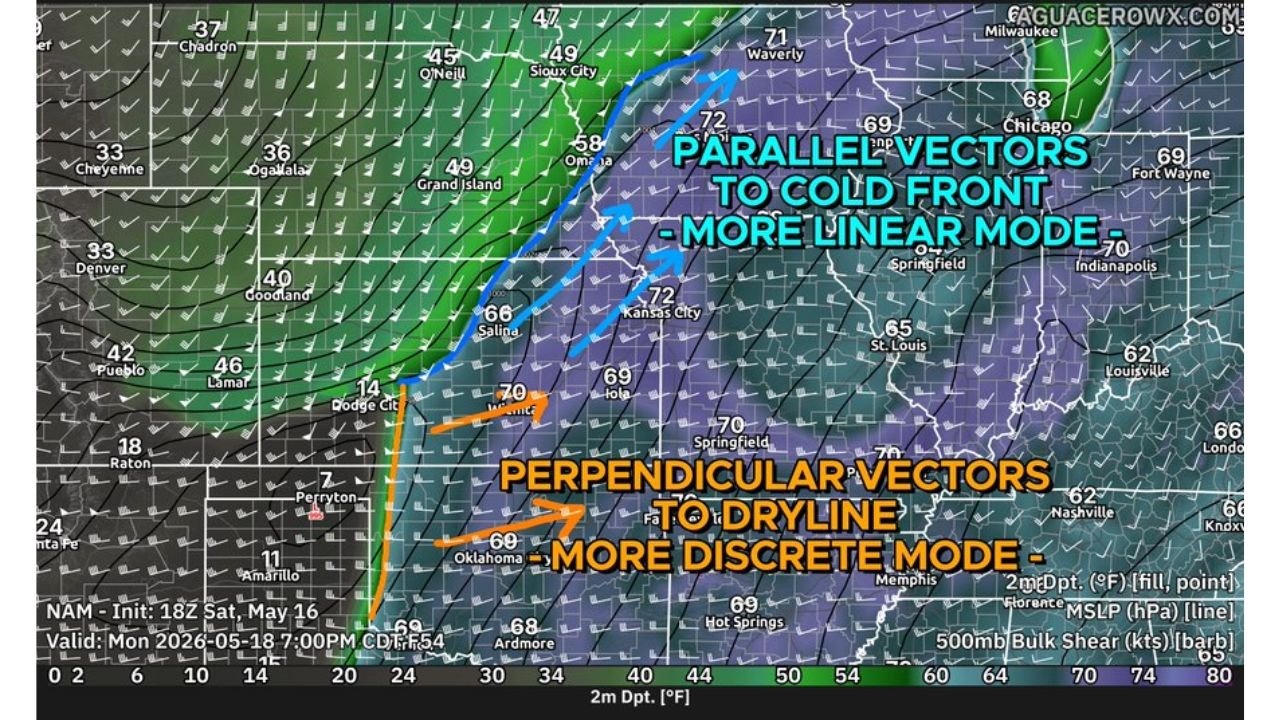
The map valid for Monday evening at 7:00 PM CDT shows two critical atmospheric setups playing out simultaneously:
- Parallel shear vectors along the cold front across the Omaha, Kansas City, and Chicago corridor are pointing toward a more linear storm mode, favoring damaging winds
- Perpendicular shear vectors along the dryline from Oklahoma through Wichita favor more discrete supercell development, maximizing the hail and tornado threat before the cold front pushes south
The timing of the cold front crashing southward through the dryline will ultimately decide which of these setups dominates Monday’s event.
The States That Must Be Ready for Either Scenario
Regardless of how the storm mode plays out, Kansas, Nebraska, Iowa, and Missouri remain at the core of the threat. Stronger forcing along the cold front means that even a linear storm mode in these states will bring significant severe weather impacts.
What Residents Should Take Away From This
The message from forecasters is straightforward. Monday is dangerous no matter what. Whether storms stay discrete and produce long-track tornadoes, or whether the cold front accelerates and drives a damaging wind event, the outcome is severe. Residents across the affected states should have their emergency plans finalized, shelters identified, and weather alerts active well before Monday afternoon arrives.
Stay with CabarrusWeekly.com for continuous updates as Monday’s storm setup becomes clearer throughout the weekend.