Alabama Flash Flood Watch in Effect for Much of the State as Rain and Thunderstorms Push Northward on Memorial Day With No Severe Weather Expected
ALABAMA — Areas of rain and thunderstorms are moving northward through Alabama on Memorial Day Monday May 25, 2026, with a Flash Flood Watch now in effect for much of the state issued by the National Weather Service. Severe storms are not expected with this system, but heavy rainfall and flash flooding remain the primary concerns as moisture-laden storms continue tracking north through the morning hours.
What the Radar Is Showing Right Now
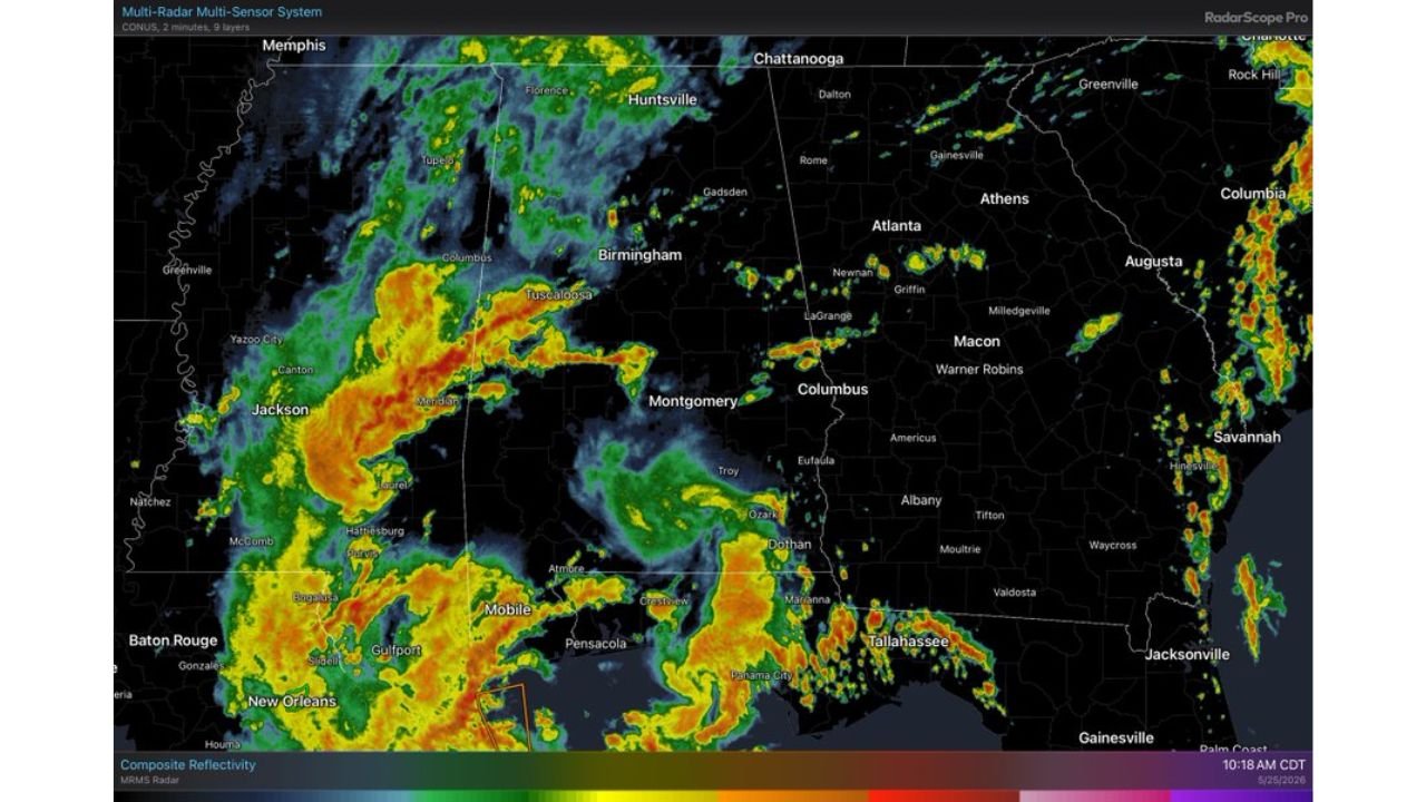
Live MRMS radar captured at 10:18 AM CDT on May 25, 2026 shows an extensive area of active rainfall and embedded thunderstorms pushing northward across Alabama and the broader region.
Current radar conditions by area:
| Area | Radar Status |
|---|---|
| Western Alabama / Tuscaloosa corridor | Heavy red and orange returns |
| Birmingham metro | Active green and yellow returns moving in |
| Huntsville | Northern edge of activity approaching |
| Montgomery area | Rain pushing northward through |
| Mobile / Atmore corridor | Heavy activity, orange and red returns |
| Jackson / Meridian Mississippi | Intense red returns, heaviest cells |
| New Orleans / Gulf Coast | Active heavy rainfall continuing |
| Dothan / Troy | Rain moving through |
| Chattanooga / Northern Alabama border | Activity approaching from south |
The heaviest radar returns are concentrated across western Alabama and into Mississippi, with intense cells showing red and deep orange reflectivity values along the leading edge of the northward-moving rain mass.
Flash Flood Watch Coverage Across the Region
The National Weather Service Flash Flood Watch covers a broad area across multiple states, with Alabama representing a significant portion of the watch zone.
Flash Flood Watch coverage breakdown:
| State | Watch Status |
|---|---|
| Much of Alabama | Flash Flood Watch in effect |
| Central and Southern Mississippi | Flash Flood Watch in effect |
| Northern Mississippi | Flash Flood Watch in effect |
| Southern Louisiana | Flash Flood Watch in effect |
| Coastal Louisiana | Flash Flood Watch in effect |
The watch zone reflects the high rainfall totals already accumulated across the region combined with the continued rounds of heavy rain pushing through on Memorial Day, creating conditions where rapid water rises and flash flooding are possible.
No Severe Weather Expected But Flooding Is the Real Threat
Forecasters have been clear that severe thunderstorms are not expected with this Memorial Day rain event. The threat profile is focused entirely on flooding.
Threat breakdown for Memorial Day:
| Threat | Status |
|---|---|
| Tornadoes | Not expected |
| Large hail | Not expected |
| Damaging winds | Not expected |
| Heavy rainfall | Ongoing and continuing |
| Flash flooding | Primary concern, watch in effect |
| Rapid water rises | Possible especially in low lying areas |
Saturated soils from days of prior rainfall across Alabama mean that even moderate additional rainfall totals can produce rapid runoff and flash flooding with little warning time.
What Alabama Residents Need to Know Right Now
With the Flash Flood Watch in effect and active radar returns across much of the state, Memorial Day outdoor plans are directly impacted.
- Never drive through flooded roadways regardless of how shallow the water appears
- Avoid low lying areas, drainage ditches, and creek banks as water can rise rapidly
- Flash flooding can occur with little warning even when rain appears light at your location
- Heavy rain upstream can cause flooding downstream without rain falling locally
- Memorial Day outdoor activities near rivers, creeks, or low areas should be suspended
- Monitor local NWS alerts for any watch upgrades to Flash Flood Warnings in your county
Rain Continues Through the Morning Before Gradual Improvement
The northward-moving storm system will continue pushing rain and embedded thunderstorms through northern Alabama and toward the Tennessee border through the morning hours. Gradual improvement is expected to work in from the south later in the day as the activity pushes out of the state.
Communities across Huntsville, Florence, and the far northern tier of Alabama should expect the rain to arrive and push through during the late morning and midday hours before conditions begin to improve.
Stay with CabarrusWeekly.com for continuing updates on the Alabama Flash Flood Watch and Memorial Day storm conditions across the state.