Minnesota Faces a 5-Day Storm Stretch With Strong T-Storms Near Minneapolis, St. Paul and Northfield Thursday After 4 PM Bringing Gusty Winds, Hail and Heavy Downpours Through Monday
MINNEAPOLIS, MINNESOTA — A 5-day stretch of storm chances is underway across Minnesota, with the first and most significant round arriving Thursday afternoon. Scattered thunderstorms with a 90% chance of afternoon storms are expected to develop in western Minnesota after 2 PM, arriving in the Twin Cities after 4 PM and moving east by 8 PM. Storms between 5 PM and 7 PM in the Twin Cities could be strong with gusty winds, brief heavy downpours, and hail.
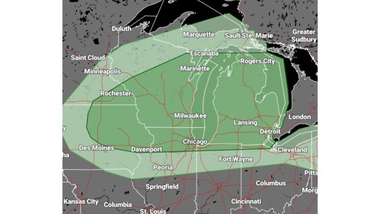
Thursday Storm Timeline — Twin Cities in the Bullseye
Future radar valid at Thursday 6:00 PM shows a intense line of storms pushing directly through the Minneapolis and St. Paul metro, with the heaviest activity centered over:
- Minneapolis, St. Paul, Edina, and Eagan — core of the storm line
- Northfield and Faribault — highest intensity storms on the southern end
- Forest Lake, Stillwater, and Maple Grove — northern portions of the corridor
- Rosemount, Prior Lake, and New Prague — southern metro exposure
Full 7-Day Forecast for the Twin Cities
| Day | Condition | High | Low |
|---|---|---|---|
| Wednesday | Sunny | 70°F | — |
| Thursday | Scattered T-Storms 90% PM | 74°F | 50°F |
| Friday | Warm and Windy | 83°F | 54°F |
| Saturday | Late PM T-Storms 40% | 80°F | 63°F |
| Sunday | Spotty T-Storms 70% | 74°F | 62°F |
| Monday | Showers and T-Storms 70% | 70°F | 62°F |
| Tuesday | Windy and Cooler | 65°F | 50°F |
Weekend and Early Week Storm Chances
The storm threat does not end Thursday. Saturday brings late PM storms with highs near 80, followed by Sunday at 70% storm coverage with heavy rain and gusty winds as the main threats. Monday carries another 70% storm chance with the strongest risk shifting southeast of the Twin Cities toward southeast Minnesota, southwest Wisconsin, and Iowa. Cooler and breezy conditions return by Tuesday with highs in the mid 60s.
Stay with CabarrusWeekly.com for daily updates as this multi-day Minnesota storm stretch unfolds through the week.