Washington D.C. and the Mid-Atlantic Hit 8 Straight Days of Rain With Strong to Severe Storms Possible Wednesday Before a Dry Pattern Finally Arrives This Weekend
WASHINGTON D.C. — Reagan National Airport has recorded measurable rainfall for 8 consecutive days as of Tuesday, with intermittent showers expected to continue through the day and a strong to severe storm threat developing Wednesday afternoon and evening that could push the streak to 9 straight rainy days. Despite the prolonged wet stretch, Reagan National’s monthly total remains several tenths of an inch below normal, and forecasters say the region still needs 8 to 12 inches of above normal rainfall over the coming months to fully end the drought.
The 8-Day Rain Streak by the Numbers
The persistent rainfall has been historically unusual for the D.C. region but has delivered meaningful drought relief across the area.
Rain streak summary:
| Stat | Detail |
|---|---|
| Consecutive rainy days at Reagan National | 8 days as of Tuesday |
| Rainfall accumulated across the region | 1.5 to 4.5 inches |
| Monthly total at Reagan National | Several tenths below normal despite the streak |
| Drought impact | Meaningful cut into the deficit |
| Additional rain needed to end drought | 8 to 12 inches above normal over coming months |
The 1.5 to 4.5 inches delivered across the region during the streak has made a real dent in drought conditions, but the numbers make clear that one wet week does not end a prolonged drought.
What Is Still Coming Through Wednesday Night
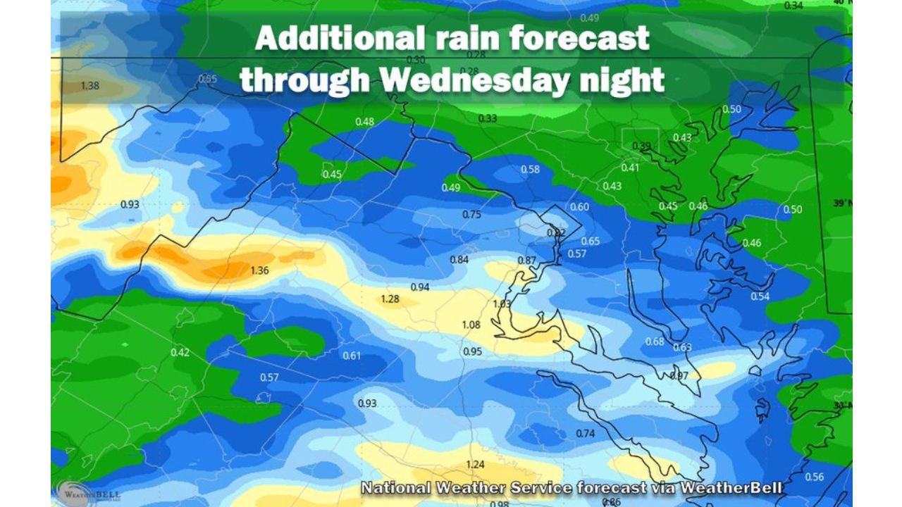
The additional rain forecast through Wednesday night shows continued meaningful accumulations across the D.C. metro and surrounding region.
Additional rainfall forecast through Wednesday night by location:
| Location | Forecast Additional Total |
|---|---|
| Washington D.C. metro core | 0.82 to 1.03 inches |
| Northern Virginia / Alexandria area | 0.87 to 1.08 inches |
| Southern Maryland | 0.94 to 1.28 inches |
| Western Maryland / Appalachian foothills | 1.36 to 1.38 inches |
| Eastern Maryland / Chesapeake area | 0.57 to 0.65 inches |
| Delaware / Eastern Shore | 0.43 to 0.60 inches |
| Northern Maryland | 0.45 to 0.49 inches |
| Philadelphia corridor | 0.41 to 0.50 inches |
| Southern Virginia | 0.74 to 0.95 inches |
| Far western region | 0.93 inches |
Today and tomorrow combined are expected to add roughly another half inch across most of the immediate D.C. metro area before the pattern begins to shift.
Wednesday Brings the Strongest Storm Threat
While Tuesday remains a day of intermittent showers, Wednesday raises the stakes significantly with organized storm development expected during the afternoon and evening hours.
Wednesday storm threat breakdown:
| Factor | Detail |
|---|---|
| Storm timing | Afternoon and evening hours |
| Storm type | Showers and thunderstorms likely |
| Strongest storm potential | A few could be strong to severe |
| Primary hazard | Damaging wind gusts |
| Secondary hazards | Heavy rain, lightning |
| Flooding concern | Elevated given already saturated ground |
The damaging wind gust threat with the strongest Wednesday storms is the headline severe weather hazard for the region. Anyone with outdoor plans Wednesday afternoon should monitor conditions closely and have an indoor option available.
The Streak Could Reach 9 or Even 10 Days
The math on the rainy day streak is straightforward but notable.
Streak extension outlook:
| Day | Streak Count | Conditions |
|---|---|---|
| Tuesday | Day 8 | Intermittent showers continuing |
| Wednesday | Day 9 | Showers and storms likely, strong to severe possible |
| Thursday | Day 10 possible | Lingering shower cannot be ruled out |
| Friday onward | Streak ends | Mostly dry stretch begins |
| Weekend | Dry | Pattern shift delivers relief |
Thursday represents a coin flip scenario where a lingering shower could push the streak to 10 consecutive rainy days before the pattern finally dries out heading into the weekend.
Drought Relief Progress and What Still Remains
Despite the impressive stretch of rainfall, the drought picture across the D.C. region remains sobering.
Drought status update:
- 1.5 to 4.5 inches of rain delivered meaningful improvement across the region
- Reagan National monthly total still running several tenths below normal despite 8 rainy days
- 8 to 12 inches above normal still needed over coming months to fully end the drought
- Recent rain helped but represents only a partial solution to a much larger deficit
- Above normal rainfall will need to persist well beyond this single wet stretch to achieve full drought recovery
Dry and Settled Weather Finally Arrives This Weekend
After what will likely be 9 or 10 consecutive rainy days, the pattern is set to flip toward a mostly dry stretch beginning Thursday or Friday and lasting through the weekend. This will be the first extended dry period the D.C. region has seen in well over a week.
Stay with CabarrusWeekly.com for continuing updates on the D.C. and Mid-Atlantic weather pattern and the Wednesday severe storm timing through the week ahead.