West and Southwest Texas Face Slight Risk Severe Weather Today With Large Hail, Damaging Winds, and Isolated Tornadoes as Supercell Development Targets Del Rio Southward
WEST AND SOUTHWEST TEXAS — The Storm Prediction Center has maintained a Slight Risk level 2 of 5 across west and southwest Texas on Tuesday May 26, 2026, as a weak trough interacts with a broad moist airmass to produce widespread severe weather across the region and into northern Mexico. Discrete supercell development is forecast south and southeast of the ongoing convective complex from near Del Rio southward, with large hail and damaging winds as the greatest threats and an isolated tornado or two also possible with the most robust storms.
Today’s Severe Weather Risk Zone
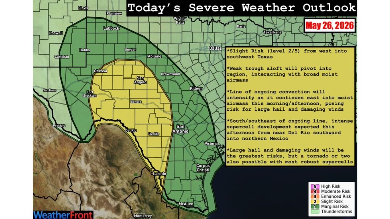
The severe weather outlook for May 26, 2026 draws a clear picture of the threat areas across Texas.
Risk breakdown by zone:
| Risk Level | Zone | Key Cities Included |
|---|---|---|
| Slight Risk (2/5) | West and Southwest Texas | Odessa, San Angelo, Del Rio, Uvalde, Laredo, Fort Stockton |
| Marginal Risk (1/5) | Broader West Texas / South Texas | Lubbock, Abilene, San Antonio, Corpus Christi, McAllen |
| General Thunderstorms | North and Central Texas | Dallas, Wichita Falls, Killeen, Brownwood |
The Slight Risk zone is centered across a broad corridor from the Odessa and San Angelo area southward through Del Rio, Uvalde, and toward Laredo, representing the highest concentration of severe weather potential today.
What the 10 AM CDT Radar Already Shows
Live radar captured at 10:00 AM CDT shows the storm complex already well underway across west Texas with a critical development zone being watched closely to the south.
Current radar and development zones:
| Area | Status |
|---|---|
| West Texas / San Angelo corridor | Active ongoing convection, heavy red and orange returns |
| Line of storms tracking eastward | Intensifying as it moves into the moist airmass |
| Del Rio area southward | Supercell development watch zone, pink dashed circle |
| Dallas corridor | Separate lighter activity to the northeast |
| San Antonio area | Largely clear, watching for afternoon development |
The pink dashed circle on the radar centered near and south of Del Rio marks the area forecasters are watching most closely for discrete supercell development during the afternoon hours.
The Two Distinct Severe Weather Threats Today
This event carries two separate and distinct storm threats operating simultaneously.
Threat 1 — The Ongoing Convective Line:
- Already active across west Texas as of 10 AM CDT
- Line of ongoing convection will intensify as it continues east into the moist airmass through this morning and afternoon
- Large hail and damaging winds are the primary hazards with this line
- Tracking eastward toward more populated areas through the day
Threat 2 — Discrete Supercell Development:
- Expected to develop south and southeast of the ongoing complex
- Focus area from near Del Rio southward into northern Mexico
- Intense supercell development forecast for this afternoon
- Large hail and damaging winds remain the greatest risks
- A tornado or two possible with the most robust supercell storms
Full Hazard Breakdown for Affected Areas
Primary severe weather hazards today across west and southwest Texas:
| Hazard | Threat Level | Most Likely Area |
|---|---|---|
| Large hail | Primary threat | Entire Slight Risk zone |
| Damaging winds | Primary threat | Along convective line and supercells |
| Tornadoes | Isolated, 1 to 2 possible | South of Del Rio with strongest supercells |
| Heavy rainfall | Secondary concern | Widespread across risk zones |
| Lightning | Ongoing with all storms | Entire affected region |
What Residents Across Affected Areas Should Do
For communities across Odessa, San Angelo, Del Rio, Uvalde, Laredo, and the broader Slight Risk zone, today requires active weather awareness through the afternoon and evening hours.
- Stay weather aware from late morning through evening as storm timing will evolve throughout the day
- Large hail can damage vehicles and property with little warning on storm arrival
- Move vehicles undercover if possible before afternoon storm development peaks
- Damaging wind gusts can accompany the convective line with minimal lead time
- Tornado threat is real but isolated — have shelter plans ready south of Del Rio
- Monitor local NWS alerts for any tornado or severe thunderstorm warnings issued during the afternoon
Stay with CabarrusWeekly.com for continuing updates on the west and southwest Texas severe weather threat through Tuesday afternoon and evening.