Coastal Mississippi and Alabama Hit With Back-Building Storms Dropping 2.5 Inches Per Hour as NWS Issues Flash Flood Threat
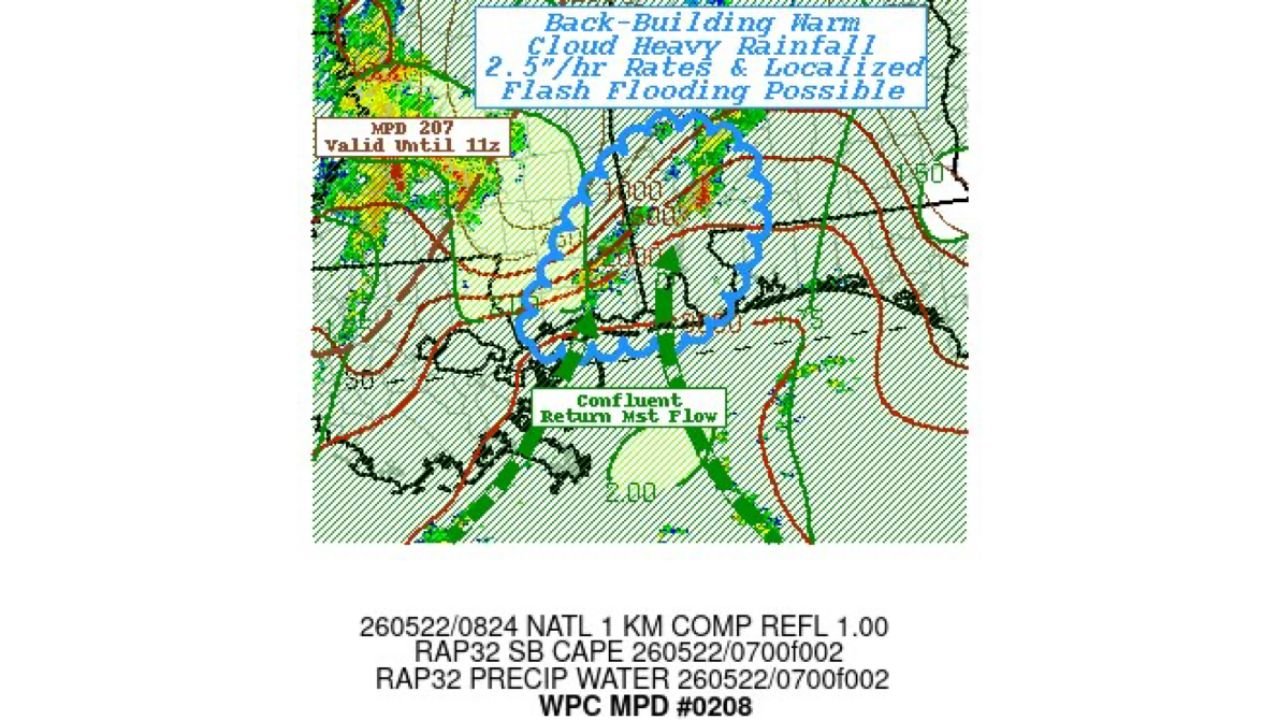
COASTAL MISSISSIPPI AND ALABAMA — The National Weather Service Weather Prediction Center has issued Mesoscale Precipitation Discussion 0208 affecting Coastal Mississippi and Alabama, with back-building warm cloud heavy rainfall rates reaching 2.5 inches per hour and localized flash flooding possible across the affected zone. A confluent return moisture flow is feeding the storm complex and keeping it anchored over the coast.
What WPC MPD 0208 Is Telling Us
Mesoscale Precipitation Discussion details:
| Detail | Information |
|---|---|
| Product | WPC MPD Number 0208 |
| Issuing Agency | NWS Weather Prediction Center |
| States Affected | Coastal Mississippi and Alabama |
| Rainfall Rate | 2.5 inches per hour |
| Storm Type | Back-building warm cloud heavy rainfall |
| Flash Flooding | Localized flash flooding possible |
| Moisture Source | Confluent return moisture flow |
| Prior MPD | MPD 207 valid until 11z still in effect |
What Back-Building Storms Mean for Flooding
Back-building is one of the most dangerous storm configurations for flash flooding. Understanding why matters for anyone in the affected area.
How back-building storms produce extreme flooding:
- New storm cells continuously develop on the upwind side of the complex
- Storms train repeatedly over the same geographic area rather than moving through
- Rainfall totals accumulate rapidly as wave after wave of heavy rain hits the same location
- 2.5 inches per hour is an extreme rainfall rate capable of causing flash flooding within minutes
- Warm cloud rainfall is efficient at producing very high rain rates with relatively shallow storm tops
- Confluent return moisture flow continuously feeds fresh Gulf moisture into the complex keeping it fueled and stationary
The Confluent Return Moisture Flow Factor
The confluent return moisture flow labeled on the WPC map is the atmospheric mechanism keeping this storm complex dangerous and anchored.
What this means:
- Gulf moisture is streaming directly into the storm complex from the south
- Confluence of moisture flow means multiple streams of humid air are converging on the same area
- The fuel supply is not running out as long as this flow pattern persists
- Storms rebuild repeatedly rather than weakening and moving away
- This is the same mechanism that produces catastrophic flood events when it locks in over populated areas
Flash Flood Risk Is Immediate and Real
With 2.5 inch per hour rainfall rates over an area that has already received significant rainfall over the past several days, the flash flood threat across Coastal Mississippi and Alabama is not theoretical.
Immediate flash flood risk factors:
- Soils already saturated from days of prior rainfall across the region
- Drainage systems at or near capacity before this storm complex arrived
- 2.5 inches per hour overwhelms any drainage system regardless of prior conditions
- Back-building nature means rain will continue accumulating beyond what a single passing storm would deliver
- Coastal geography limits drainage paths and increases inundation risk
What Residents Must Do Right Now
Anyone across Coastal Mississippi and Alabama inside or near the affected zone needs to act immediately.
- Never drive through flooded roadways under any circumstances
- Turn around, do not drown — most flood fatalities occur in vehicles
- Move immediately to higher ground if water begins rising near your location
- Stay off roads during peak rainfall rates as conditions can change within seconds
- Monitor NWS flash flood warnings which may be issued for specific counties at any time
- Do not underestimate the speed at which water can rise with 2.5 inch per hour rainfall rates
Stay with CabarrusWeekly.com for continuing updates on the Coastal Mississippi and Alabama flash flood threat as WPC MPD 0208 remains in effect.