Kansas, Oklahoma, Nebraska and Missouri Face Explosive Supercell Threat as Week 3 Composite Parameter Lights Up June 10 to 16
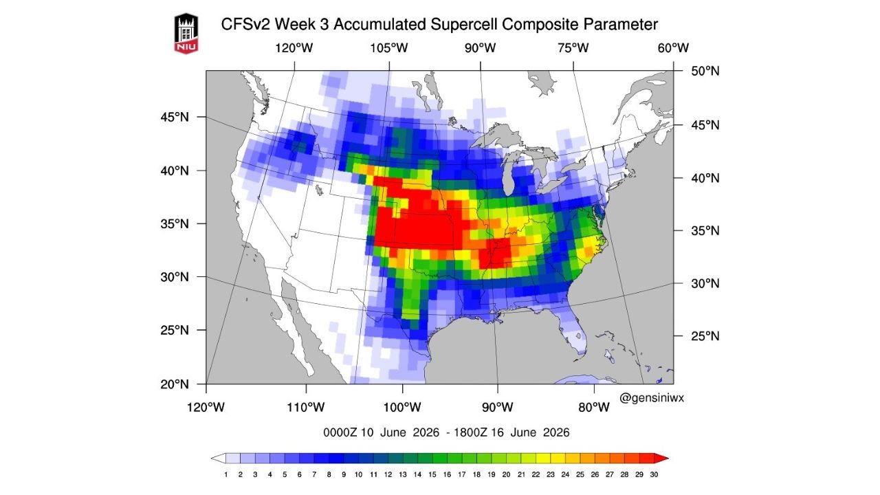
UNITED STATES — Long-range severe weather guidance is flagging a significant supercell threat for the central United States during the period of June 10 through June 16, 2026. The Week 3 Accumulated Supercell Composite Parameter map shows deep red values concentrated across Kansas, Oklahoma, Nebraska and Missouri, signaling conditions favorable for prolific supercell thunderstorm development during this timeframe.
What the Supercell Composite Parameter Means
The Supercell Composite Parameter (SCP) is a multi-ingredient index that measures how favorable atmospheric conditions are for supercell thunderstorm development. It combines wind shear, instability and storm-relative helicity into a single value. Higher values indicate a more favorable environment for rotating, long-lived supercell storms capable of producing large hail, damaging winds and tornadoes.
The accumulated version shown here reflects the buildup of favorable conditions across the entire June 10 to 16 period, not just a single moment in time.
The Red Zone: Where the Highest Risk Is Concentrated
The map’s deepest red shading, representing the highest accumulated SCP values on the scale, is centered across:
- Kansas across nearly the entire state
- Northern Oklahoma
- Southern Nebraska
- Western and central Missouri
- A secondary red core appearing across parts of Tennessee and the mid-South
Values in the red zone reach the upper end of the scale, with the color bar extending to 30. The core of the highest values sits squarely across central and southern Kansas extending into northern Oklahoma, the traditional heart of tornado alley.
The Broader Risk Footprint
Outside the deep red core, orange, yellow and green shading extends the elevated risk zone significantly:
- Colorado and Wyoming show elevated values along the eastern slopes
- Iowa, Illinois and Indiana fall within the green to yellow range
- Arkansas, Mississippi and Alabama show meaningful SCP values
- Virginia and the Carolinas show lighter but non-zero values along the East Coast
June Severe Weather Season in Focus
This signal aligns with the typical mid-June severe weather season across the central Plains, when atmospheric dynamics often support some of the most intense supercell outbreaks of the year. The pattern suggested by this guidance would represent a significant severe weather stretch if it verifies, potentially impacting millions of residents across tornado alley and the broader mid-South.
This is long-range guidance and confidence increases as the date approaches. Residents across Kansas, Oklahoma, Nebraska and Missouri should monitor forecasts closely as June 10 draws nearer.
Stay with CabarrusWeekly.com for continuing coverage as this potential severe weather pattern is tracked through early June.