Eastern Pacific Tropical Development Reaches 90 Percent Chance as Second Area of Interest Emerges Off Southern Mexico Coast on May 31
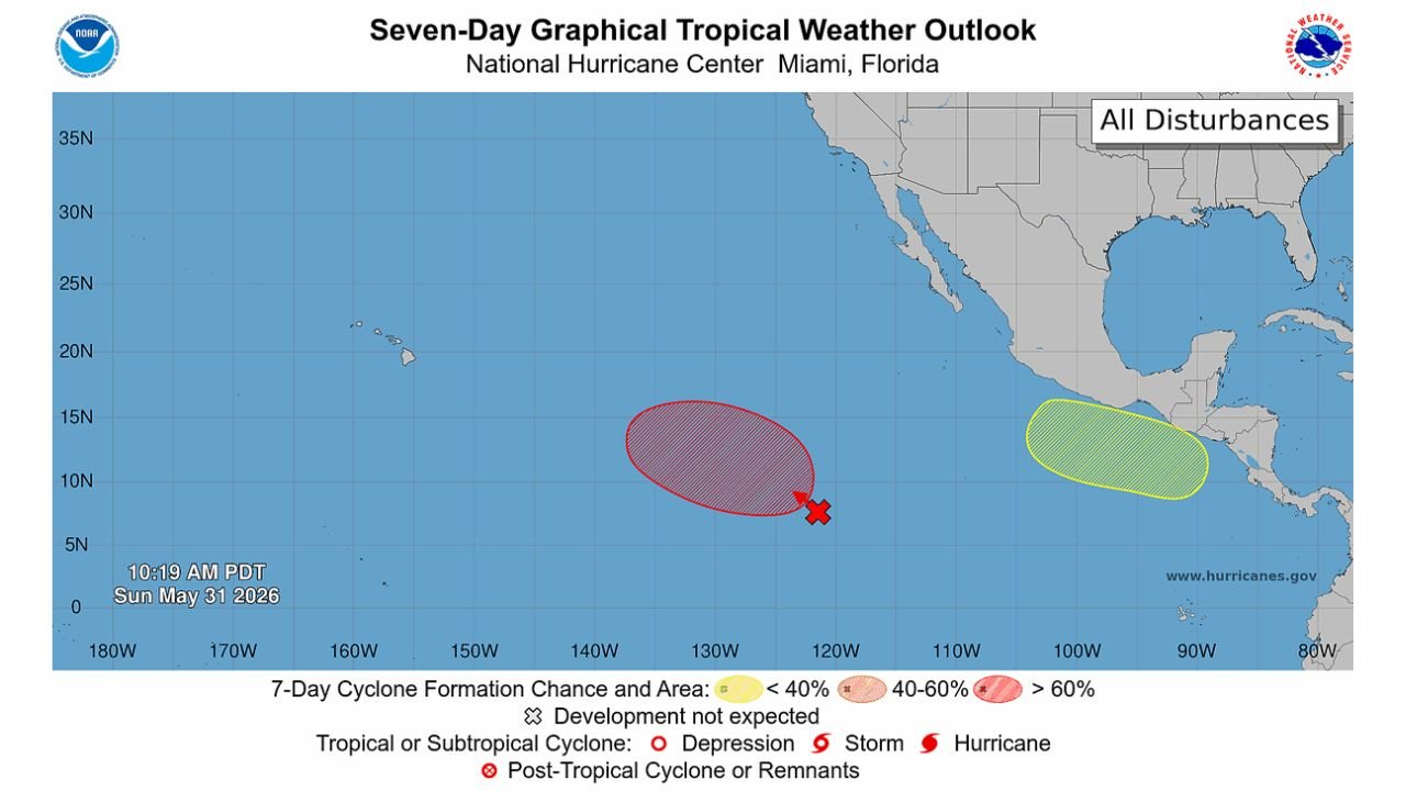
EASTERN PACIFIC OCEAN — The National Hurricane Center is tracking two separate areas of tropical interest in the Eastern Pacific as of 10:19 AM PDT on Sunday, May 31, 2026, with the primary disturbance now carrying a 90 percent chance of development over the next several days. A tropical depression formation is possible in the coming days from the lead system, while a newly identified second disturbance off the coast of Southern Mexico carries a 20 percent development chance over the next 7 days.
The Primary Disturbance: 90 Percent Development Chance
The lead area of interest, shown in deep red hatching on the NHC Seven-Day Graphical Tropical Weather Outlook, is positioned in the central Eastern Pacific near 120 to 125 degrees West longitude at approximately 8 to 10 degrees North latitude. Key details:
- Development probability: 90 percent over the next 7 days
- The red color and dense hatching indicate a greater than 60 percent formation chance, the highest tier on the NHC graphic
- A tropical depression is possible over the next few days as the system organizes
- The disturbance is located well out in the open Eastern Pacific, far from any land areas at this time
The Secondary Disturbance: Off Southern Mexico
A newly identified area of interest has appeared in yellow on the NHC graphic, positioned off the coast of Southern Mexico in the far eastern Pacific near Central America. Details:
- Development probability: 20 percent over the next 7 days
- Yellow shading indicates a less than 40 percent formation chance
- This is an early-stage and low-confidence signal at this time
- Location places it closer to Mexican and Central American coastlines than the primary disturbance
What the Graphic Is Showing
The Seven-Day Graphical Tropical Weather Outlook from the National Hurricane Center in Miami is valid as of 10:19 AM PDT on May 31, 2026. The map shows both disturbances simultaneously, with the primary red system centered in the open Pacific and the secondary yellow system hugging the Southern Mexico coast. No named storms or organized depressions are currently present in the Eastern Pacific basin.
What to Watch Going Forward
The 90 percent probability system is the one to watch closely over the coming days. At that confidence level, tropical depression formation is considered likely barring unexpected atmospheric interference. Should the system organize into a named storm, it would be the first of the Eastern Pacific hurricane season.
The Southern Mexico disturbance at 20 percent remains a low-probability signal and requires significant additional development before posing any meaningful threat.
Stay with CabarrusWeekly.com for continuing updates as Eastern Pacific tropical development is monitored through the coming days.