Kentucky Storm System Feb. 14–15 Could Bring Saturday Night Rain, Thunderstorms, and Soaking Downpours as Temperatures Rebound
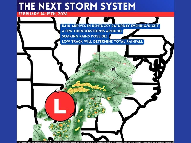
KENTUCKY — A new storm system is expected to turn weather more active heading into Friday and Saturday, with temperatures climbing again Saturday afternoon before rain arrives in Kentucky Saturday evening and night, according to the forecast graphic for February 14–15, 2026.
Rain Arrives Saturday Evening and Night Across Kentucky
The storm timeline shown in the update places Kentucky’s main rain arrival window in the Saturday evening into Saturday night period. The precipitation shield on the map covers much of the state, indicating a widespread rain event rather than a brief isolated shower setup.
A Few Thunderstorms Are Possible
The forecast notes that a few thunderstorms could be involved as the system moves in. That suggests at least some parts of Kentucky could see:
- Lightning
- Gusty winds in heavier cells
- Brief heavier rainfall bursts embedded within broader rain
Soaking Rains Could Develop in Spots
The update also flags soaking rains possible, a signal that rainfall could become persistent for a time as the system passes. This is especially important for low-lying or poor-drainage areas that can flood quickly when rain rates increase.
The Low’s Track Will Determine Total Rainfall
One of the key points in the forecast is that the low track will determine total rainfall. In practical terms, small shifts north or south in the storm center can change:
- Where the heaviest rain axis sets up
- How long steadier rain lasts
- Which locations see the most thunderstorm activity
That’s why totals may still be somewhat uncertain this far out, even though the overall rain timing is becoming clearer.
What To Watch Next
As the system gets closer, the most important updates will be:
- Whether thunderstorm coverage increases or stays isolated
- If the heaviest rain focuses over western, central, or eastern Kentucky
- Whether rainfall trends toward a quick-moving event or a longer soaking period
CabarrusWeekly.com will keep tracking notable regional storm setups and the way they evolve, especially when they signal changing late-winter patterns across the eastern U.S. If you’re in Kentucky, share what conditions look like in your area as the Saturday night rain arrives at CabarrusWeekly.com.