Alabama Set for Week-Long Warm Surge With 70s and Low 80s as Upper Ridge Builds Over Florida and Expands Across the Deep South
ALABAMA — A developing upper-level ridge centered over Florida is locking in a prolonged warm pattern across the Deep South, sending afternoon highs into the 70s and low to mid 80s across Alabama for at least the next seven days.
Upper High Over Florida Anchors Warm, Dry Pattern
Forecast data shows a strengthening upper high building over Florida in the coming days. This ridge will act as a protective dome, steering primary storm systems north and west of Alabama, keeping widespread rainfall limited through much of the week.
With sinking air beneath the ridge, skies will remain mostly clear and temperatures will respond efficiently to daytime heating. As a result, much of Alabama will experience above-normal warmth, consistent with broader 8–14 day outlook guidance highlighting the Deep South for sustained above-average temperatures.
Highs Climb Into the 80s Midweek
Daily temperature projections indicate highs rising steadily through the week. Many communities across central and southern Alabama are expected to see:
Upper 70s early in the week
Low 80s by midweek
Mid 80s possible in the warmest spots
Overnight lows will also trend milder, generally in the mid to upper 50s early, climbing into the lower 60s later in the week. This will create a noticeably spring-like feel across the region.
The warmest stretch appears centered around Wednesday through Friday, when the ridge reaches peak strength.
Rain Chances Remain Limited — For Now
With the ridge dominating the Deep South, organized rain-producing systems will track north and west of Alabama. Only isolated showers late in the week are possible, and most locations are expected to remain dry through at least Friday.
The dry stretch will allow soils to warm and early-season vegetation to respond quickly to the persistent warmth.
Pattern Shift Possible by Next Weekend
The ridge is forecast to gradually weaken by the weekend of March 7–8, allowing moisture and storm systems to begin edging back into the region.
As the upper high breaks down, an increase in showers and possibly thunderstorms is expected. While severe weather is not explicitly indicated in this specific outlook, the transition period will be monitored closely as the protective ridge relaxes.
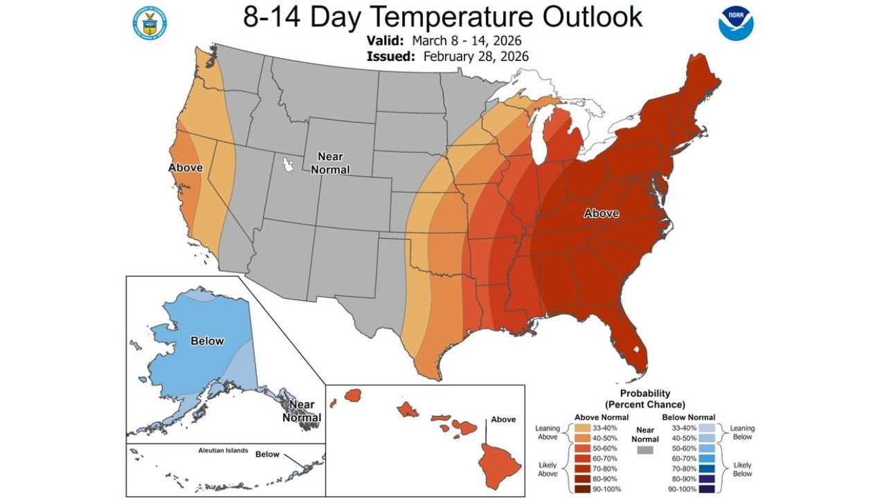
8–14 Day Outlook Supports Continued Above-Normal Temperatures
Longer-range outlook guidance valid March 8–14 continues to show a broad swath of the eastern United States, including Alabama and the Deep South, favored for above-normal temperatures.
This suggests that even with increasing rain chances next weekend, the overall temperature pattern may remain on the warm side relative to early March averages.
Residents across Alabama should prepare for a stretch of spring-like afternoons, limited rainfall, and gradually increasing humidity as the ridge evolves.
If you’re noticing early blooms, rising pollen, or unusually warm afternoons in your community, share your local conditions with us at CabarrusWeekly.com as we continue tracking this developing warm pattern.
Author: Cabarrus Weekly Weather Desk | Category: Weather
Alabama Set for Week-Long Warm Surge With 70s and Low 80s as Upper Ridge Builds Over Florida and Expands Across the Deep South
Meta Title
Alabama Warm Pattern Brings 70s and 80s for the Next Seven Days
Meta Description
A strengthening upper ridge over Florida will push Alabama highs into the 70s and low 80s for at least a week before showers increase next weekend.
Author: Cabarrus Weekly Weather Desk | Category: Weather
ALABAMA — A developing upper-level ridge centered over Florida is locking in a prolonged warm pattern across the Deep South, sending afternoon highs into the 70s and low to mid 80s across Alabama for at least the next seven days.
Upper High Over Florida Anchors Warm, Dry Pattern
Forecast data shows a strengthening upper high building over Florida in the coming days. This ridge will act as a protective dome, steering primary storm systems north and west of Alabama, keeping widespread rainfall limited through much of the week.
With sinking air beneath the ridge, skies will remain mostly clear and temperatures will respond efficiently to daytime heating. As a result, much of Alabama will experience above-normal warmth, consistent with broader 8–14 day outlook guidance highlighting the Deep South for sustained above-average temperatures.
Highs Climb Into the 80s Midweek
Daily temperature projections indicate highs rising steadily through the week. Many communities across central and southern Alabama are expected to see:
Upper 70s early in the week
Low 80s by midweek
Mid 80s possible in the warmest spots
Overnight lows will also trend milder, generally in the mid to upper 50s early, climbing into the lower 60s later in the week. This will create a noticeably spring-like feel across the region.
The warmest stretch appears centered around Wednesday through Friday, when the ridge reaches peak strength.
Rain Chances Remain Limited — For Now
With the ridge dominating the Deep South, organized rain-producing systems will track north and west of Alabama. Only isolated showers late in the week are possible, and most locations are expected to remain dry through at least Friday.
The dry stretch will allow soils to warm and early-season vegetation to respond quickly to the persistent warmth.
Pattern Shift Possible by Next Weekend
The ridge is forecast to gradually weaken by the weekend of March 7–8, allowing moisture and storm systems to begin edging back into the region.
As the upper high breaks down, an increase in showers and possibly thunderstorms is expected. While severe weather is not explicitly indicated in this specific outlook, the transition period will be monitored closely as the protective ridge relaxes.
8–14 Day Outlook Supports Continued Above-Normal Temperatures
Longer-range outlook guidance valid March 8–14 continues to show a broad swath of the eastern United States, including Alabama and the Deep South, favored for above-normal temperatures.
This suggests that even with increasing rain chances next weekend, the overall temperature pattern may remain on the warm side relative to early March averages.
Residents across Alabama should prepare for a stretch of spring-like afternoons, limited rainfall, and gradually increasing humidity as the ridge evolves.
If you’re noticing early blooms, rising pollen, or unusually warm afternoons in your community, share your local conditions with us at CabarrusWeekly.com as we continue tracking this developing warm pattern.