Florida Faces Torrential Downpours and Lots of Lightning Near Orlando This Afternoon and Evening Tuesday May 12 as Stalled Front and 150 to 200 Percent Above Normal Moisture Fuel Big Storms
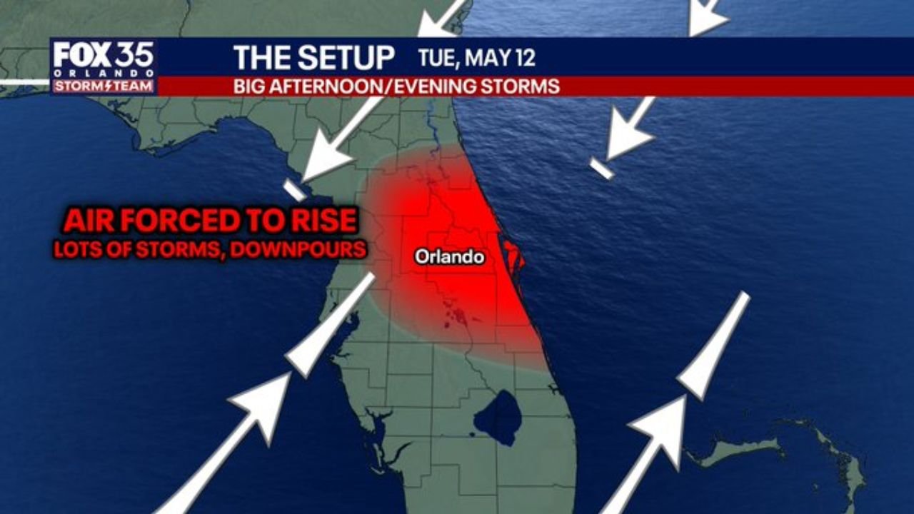
ORLANDO, Florida — A classic setup for big storms and torrential downpours is in place across the Florida Peninsula this afternoon and evening, Tuesday, May 12, 2026, with a stalled front and low pressure forcing air to rise through an exceptionally moist atmosphere centered near Orlando.
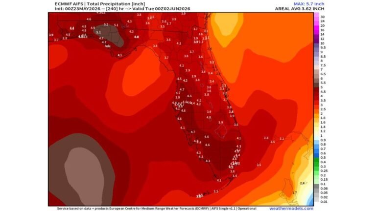
Atmospheric moisture levels are running 150 to 200 percent above normal this afternoon, creating the fuel needed for very efficient and torrential downpours with frequent lightning across the Florida Peninsula through this evening.
Why This Setup Is So Dangerous
Three ingredients are coming together simultaneously over Florida today to create an unusually potent storm environment:
- A stalled front combined with low pressure is forcing air to rise rapidly across the Florida Peninsula near Orlando, and when moist air is forced upward quickly it explodes into towering thunderstorms capable of producing torrential rainfall and frequent lightning in a very short period of time.
- Atmospheric moisture, measured as the total amount of water vapor available in the air column, is running at 150 to 200 percent of normal levels this afternoon across Florida. This means storms will have far more water to work with than a typical Florida afternoon thunderstorm, resulting in much heavier rainfall rates and more intense lightning activity.
- Instability above the freezing layer, which is the zone high in the atmosphere where temperatures drop below 32 degrees, is adding additional energy to storm development and making thunderstorm cells taller, more intense and capable of producing more frequent lightning strikes than usual.
Colliding Winds Create the Storm Zone
Two different wind directions are colliding directly over the Florida Peninsula near Orlando this afternoon, and that collision zone is where the biggest storms will develop:
- Northeast winds are flowing southwestward across northern Florida and into the Orlando area from the Atlantic side of the state.
- Southwest winds are flowing northeastward across southern Florida and the Gulf Coast into the same Orlando area from the opposite direction.
- When northeast winds and southwest winds collide over the same area, air has nowhere to go but upward. That forced rising motion directly over the Florida Peninsula near Orlando is the engine driving today’s big storm and downpour threat through this afternoon and evening.
What to Expect This Afternoon and Evening
The storm setup maps valid Tuesday, May 12 show the most intense storm development zone centered directly over the Florida Peninsula including Orlando and surrounding communities:
- Torrential downpours capable of producing very heavy rainfall in a short period of time are the primary threat this afternoon and evening across the Florida Peninsula near Orlando.
- Frequent lightning will accompany the strongest storm cells given the high instability levels above the freezing layer. This is not a day to be outdoors anywhere near Orlando or across the broader Florida Peninsula during the afternoon and evening hours.
- The stalled front means storms may train over the same areas repeatedly rather than moving through quickly, increasing the risk of localized flooding in low-lying areas near Orlando and across the Florida Peninsula.
Safety Actions for Right Now
Residents and visitors across Orlando and the Florida Peninsula should take immediate action this afternoon:
- Get indoors now if you are outside anywhere near Orlando or across the Florida Peninsula. With moisture running at 150 to 200 percent above normal, storms can explode from clear skies to torrential downpours with frequent lightning in minutes.
- If you are caught outside when lightning begins, do not shelter under trees. Get inside a sturdy building or hard-topped vehicle and stay there until 30 minutes after the last thunder is heard.
- Avoid driving through flooded roadways this afternoon and evening near Orlando. With torrential rainfall rates possible from training storm cells, even familiar roads can flood rapidly and 6 inches of moving water is enough to sweep a person off their feet.
Cabarrusweekly.com will continue tracking torrential downpours, frequent lightning and the stalled front storm setup across the Florida Peninsula near Orlando and will provide updates as rainfall totals, storm coverage and flooding reports develop through Tuesday, May 12 evening.