Florida, Georgia, Alabama, Mississippi, Tennessee, and the Carolinas Face Up to 8 Inches of Rain Through June 6 as Low Pressure Signal Develops Across the Gulf Heading Into June
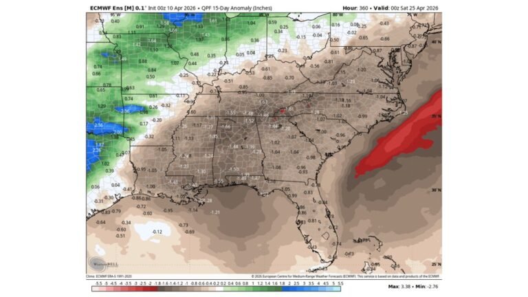
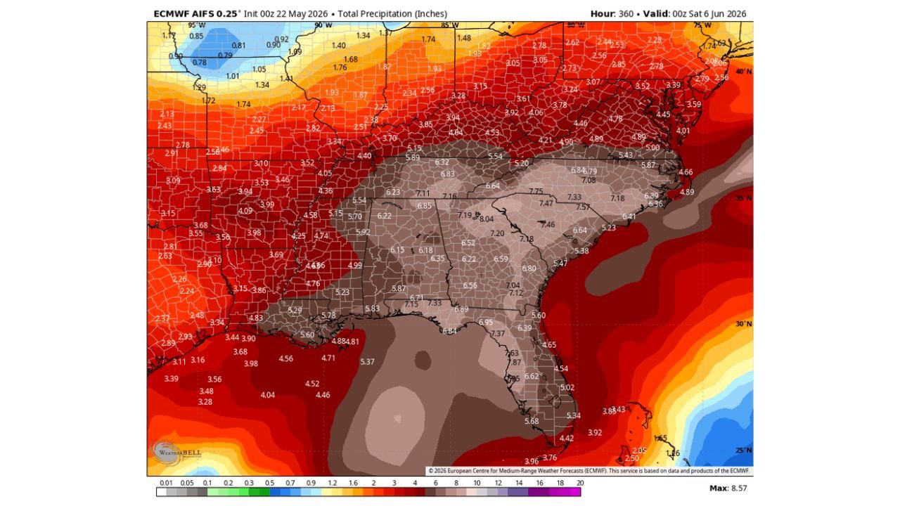
SOUTHEASTERN UNITED STATES AND FLORIDA — Long-range forecast data valid through Saturday, June 6, 2026 is showing an extraordinary rainfall signal across the Southeast and Florida, with total precipitation forecast reaching up to 8.57 inches across the heaviest zones. Adding to the concern, a low pressure signal is developing across the Gulf of Mexico and into Florida and the Southeast as the calendar turns toward June, raising the stakes for an already wet and active pattern across this region.
The Rainfall Totals Are Staggering Through June 6
The 15-day total precipitation forecast paints a picture of one of the wettest stretches the Southeast has seen in years. The core of the heaviest rainfall is centered across a broad corridor from Mississippi and Alabama through Tennessee, Georgia, and the Carolinas:
| Region | Forecast Total Through June 6 |
|---|---|
| Tennessee and Georgia core | 7.18 to 8.04 inches |
| North Carolina and South Carolina | 6.84 to 7.57 inches |
| Mississippi and Alabama | 6.83 to 7.16 inches |
| Louisiana and Mississippi corridor | 5.78 to 7.33 inches |
| Virginia and Maryland | 4.89 to 6.84 inches |
| Florida | 3.76 to 7.87 inches |
| Texas | 3.28 to 4.86 inches |
| Northeast corridor | 2.28 to 4.01 inches |
| Midwest | 1.87 to 3.94 inches |
A Gulf Low Pressure Signal Adds to the Concern
Beyond the already significant rainfall totals already in the forecast, long-range data is also detecting lower pressure developing across the Gulf of Mexico and pushing into Florida and the Southeast as June approaches. This developing low pressure signal could act as an additional moisture pump and rainfall enhancer across the region, potentially pushing totals even higher than currently forecast as confidence in the signal increases over coming days.
Flooding Is the Dominant Risk Through June 6
With 7 to 8 inch rainfall totals forecast across Tennessee, Georgia, Alabama, Mississippi, and the Carolinas over a 15-day period, flash flooding and river flooding will be the dominant weather hazard across the Southeast through June 6. Communities along rivers and in low-lying areas across this entire corridor should be monitoring flood guidance closely as this extended wet pattern continues to evolve.
Every Southeast State Needs to Be Watching This Pattern
From Texas in the west through Florida in the south and up through Virginia in the north, every state in the Southeast corridor is sitting inside a significant above-normal rainfall zone through the first week of June. This is a region-wide, multi-week weather event that demands sustained attention and preparation.
Stay with CabarrusWeekly.com for daily updates on rainfall totals, flood risks, and the developing Gulf pressure signal through June 6.