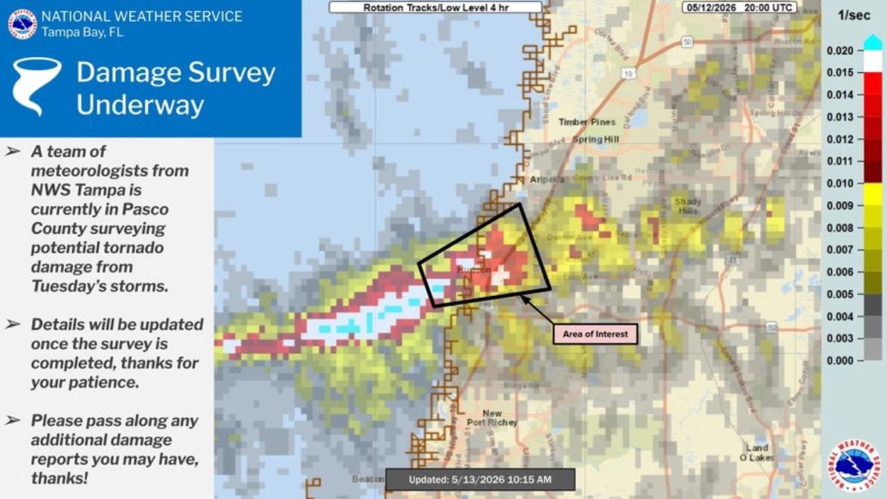
Florida’s Pasco County Under NWS Damage Survey After a Rotating Supercell Came Ashore North of Tampa Bay Tuesday May 12 With Potential Tornado Damage Near Elgin and Spring Hill
PASCO COUNTY, FLORIDA — The National Weather Service in Tampa Bay has launched a damage survey in Pasco County following Tuesday’s storms, after a rotating supercell came ashore north of Tampa Bay on May 12, 2026. NWS meteorologists are on the ground surveying potential tornado damage in the area, with rotation track data updated at 10:15 AM on May 13, 2026 showing a concentrated area of interest near Elgin and Spring Hill.
What the Rotation Track Data Shows
Low-level rotation track data valid at 20:00 UTC May 12, 2026 shows a well-defined corridor of rotation values pushing inland from the Gulf Coast:
- Highest rotation values — deep red and cyan readings concentrated directly over the Elgin area, marked as the primary area of interest
- Elevated rotation corridor — tracking northeast from the coastline through Spring Hill and toward Shady Hills
- Broader rotation zone — extending south toward New Port Richey along the Gulf Coast
NWS Survey Currently Underway
- NWS Tampa meteorologists are currently in Pasco County conducting the survey
- The team is assessing potential tornado damage from Tuesday’s storms
- Survey results and damage classification will be released once the assessment is complete
- Anyone with additional damage reports in the area is asked to pass them along to NWS Tampa
What Comes Next
Once the damage survey is completed, NWS Tampa will confirm whether a tornado touched down or whether the damage was caused by other severe weather mechanisms associated with the rotating supercell. Results are pending as of Wednesday morning May 13.
Stay with CabarrusWeekly.com for the latest updates as the NWS damage survey in Pasco County concludes.