Illinois, Indiana, Ohio and Missouri Face Strong to Severe Storm Risk Monday With 60 MPH Winds, Hail and Isolated Tornadoes Possible
UNITED STATES — After a welcome break from severe weather, another storm system is on the way for Monday, May 4, 2026, targeting the Midwest and Ohio Valley. Confidence in exact timing and coverage remains lower than usual, but the threat is real enough to merit close monitoring heading into the start of the week. The outlook was updated at 5:25 AM ET on May 1, 2026.
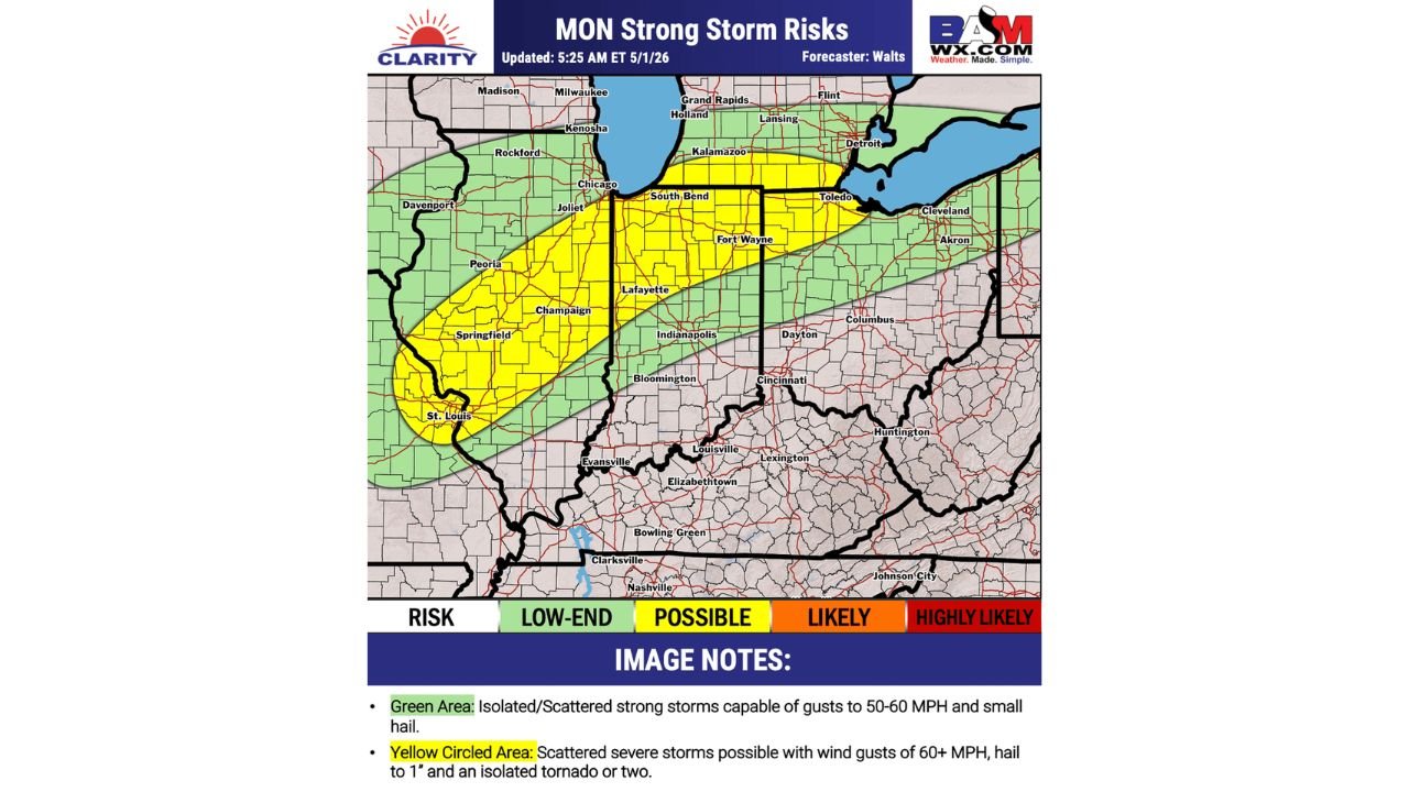
Two Risk Zones in Place for Monday
Yellow Zone — Scattered Severe Storms Possible: The highest risk area covers a diagonal band stretching from St. Louis, Springfield, Peoria, Champaign, and Chicago eastward through Joliet, South Bend, Fort Wayne, Toledo, and toward Cleveland and Akron. Cities directly within this zone include Lafayette, Indianapolis, Bloomington, and Dayton.
For this yellow zone, scattered severe storms are possible with:
- Wind gusts of 60 MPH or greater
- Hail up to 1 inch
- An isolated tornado or two
Green Zone — Low-End Severe Risk: A broader green zone surrounds the yellow area, covering much of Illinois, Indiana, Ohio, Kentucky, Tennessee, and West Virginia. Cities in this zone include Rockford, Davenport, Columbus, Cincinnati, Louisville, Lexington, Evansville, Bowling Green, Nashville, Clarksville, Huntington, and Johnson City.
For the green zone, isolated to scattered strong storms are possible with:
- Wind gusts of 50 to 60 MPH
- Small hail
Timing and Confidence
Confidence in the exact timing and coverage of Monday’s storm system is lower than typical for a system this close in time. Residents across the outlined zones should continue monitoring updated forecasts through the weekend as the system comes into sharper focus.
What to Watch Heading Into Monday
The yellow zone from St. Louis through Indianapolis and into the Toledo and Cleveland corridor carries the most focused severe weather potential. Anyone in this corridor should have multiple ways to receive warnings in place before Monday arrives.
Stay with CabarrusWeekly.com for continuing updates on Monday’s storm threat across the Midwest and Ohio Valley.