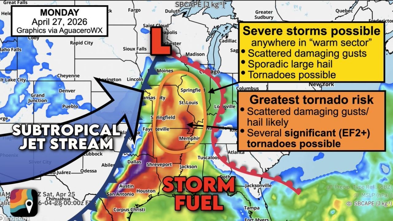
Memphis, St. Louis and Western Kentucky Face Several EF2 Tornadoes Monday as the Mississippi Valley Warm Sector Covers Six States Simultaneously
MEMPHIS, Tennessee — Monday, April 27 is arriving as advertised — and the forecast has not gotten any friendlier. The greatest tornado risk of the day is centered on a corridor covering eastern Missouri, northeast Arkansas, northern Mississippi, western Tennessee, western Kentucky, and southern Illinois and Indiana, with several significant EF2 or stronger tornadoes expected alongside sporadic damaging winds and large hail.
The mechanism is straightforward and dangerous. Low pressure over the Upper Midwest is pulling a massive warm sector of Gulf air northward across an enormous area. A roaring subtropical jet stream overhead is loading the atmosphere with wind shear. Any thunderstorm that grows tall enough to reach those changing winds will spin. The question that determines how bad Monday gets is whether those spinning storms stay discrete or merge into a line.
The Warm Sector Is Enormous — That Is the Problem
The orange greatest tornado risk oval on Monday’s map sits over Kansas City, St. Louis, Springfield Missouri, Fayetteville Arkansas, Memphis, and Nashville — a corridor covering hundreds of miles simultaneously. The broader yellow warm sector extends the severe storm threat from Iowa and Illinois in the north all the way south to Shreveport, Jackson, and Houston.
That geographic scale is not an exaggeration for effect. The low pressure system pulling Gulf moisture north is doing so across an extraordinarily wide warm sector. When a warm sector this large fills with juiced-up, unstable air, severe thunderstorms can blossom nearly anywhere within it — not just along the main cold front. That is why the forecast explicitly warns that severe storms are possible anywhere in the warm sector, not just in the highlighted core zones.
Rogue supercells forming through warm air advection in Iowa and Illinois are specifically called out — storms that pop ahead of the main front as warmth pumps northward, well away from where most people expect the threat. Missouri south of Kansas City also faces isolated supercell development where dry air is pushing east against the moisture boundary.
The Storm Mode Question That Decides Everything
The fundamental uncertainty Monday is the same one that has defined this entire outbreak week: discrete supercells or a merged squall line.
Discrete supercells produce tornadoes. They maintain individual rotation, have clear access to warm inflow air, and can sustain themselves for hours over long tracks. If Monday’s storms stay separated and organized as individual supercells across the mid-Mississippi Valley, the EF2 tornado threat is real and the possibility of longer-track significant tornadoes is genuine.
If those same storms merge into a line or cluster as the cold front pushes through, the tornado threat decreases and damaging straight-line winds become the dominant hazard across a wider area. Wind damage from a well-organized squall line with the jet stream overhead can be nearly as destructive as a weak tornado across a much broader swath of territory.
Either outcome produces damaging severe weather. Only one produces the EF2 tornadoes that the forecast is flagging. Forecasters are explicit: at least some tornadoes are likely regardless of storm mode, and if supercells maintain themselves, significant and perhaps longer-track tornadoes are possible.
Memphis and Western Tennessee Are in the Bull’s-Eye
Memphis sits directly inside the orange greatest tornado risk zone on Monday’s map. Western Tennessee including Jackson and Dyersburg face the highest local tornado exposure of anywhere in the state. The subtropical jet stream is positioned to roar directly over this corridor, providing the overhead wind energy that tilts and organizes thunderstorm updrafts into rotating supercells.
The storm fuel map shows surface-based CAPE values running through the deep red and purple color range across Tennessee, Mississippi, and Arkansas on Monday — instability readings in the range of 3,000 to 5,000 J/kg based on previous model data for this event. That is the kind of atmospheric energy that produces explosive storm development once triggering begins.
Northern Mississippi including Oxford, Corinth, and Tupelo sits on the southeastern edge of the orange zone. These communities are directly in the path of any supercell that develops over Arkansas and tracks east-northeast through the afternoon.
Southern Illinois and Indiana Are Not Peripheral
Southern Illinois including Carbondale, Marion, and Mount Vernon sits inside the greatest tornado risk zone on Monday. Evansville, Indiana and surrounding southwestern Indiana communities are also directly inside the core threat corridor.
These locations often get overlooked in Mississippi Valley tornado discussions because the conversation naturally focuses on Tennessee, Arkansas, and Mississippi. But southern Illinois and southwestern Indiana are sitting in the warm sector with the same instability, the same wind shear, and the same jet stream overhead as Memphis. The threat is equally real across this corridor.
St. Louis sits at the northern edge of the orange zone where supercell development is also possible through warm air advection processes ahead of the front.
Western Kentucky Has Particular Exposure
Western Kentucky including Paducah, Mayfield, and the Jackson Purchase region is directly inside the greatest tornado risk area. This part of Kentucky sits at the confluence of the Ohio and Mississippi rivers in flat terrain that provides no topographic protection and allows tornadoes to travel long distances without natural obstacles.
Paducah specifically sits at the junction of four states — Kentucky, Missouri, Illinois, and Tennessee — and is one of the locations where a long-track tornado moving northeast could affect the largest number of communities across state lines in a single track.
What Happens After Initiation Depends on One Thing
Once thunderstorms fire Monday afternoon, the next 30 to 60 minutes will be the most critical observation period of the entire day. That is the window where forecasters watching radar will determine whether storms are holding together as discrete supercells or merging prematurely. If supercells hold through the first hour after initiation, Monday escalates into a significant tornado outbreak. If they merge quickly, the damage focus shifts to wind.
Either way, everyone inside the warm sector from Iowa to Louisiana needs to be in weather-aware mode from noon Monday through midnight. The warm sector is enormous, the energy available is extraordinary, and the subtropical jet stream overhead is not subtle.
CabarrusWeekly.com will provide continuous updates through Monday as storms develop across the Mississippi Valley and the outbreak scenario evolves in real time.